
Zumbro River in Minnesota
Trip Overview
North Branch of the Zumbro River
Mazeppa, MN to Sportsman Park on the Zumbro River in Zumbro Falls, MN
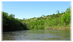
The gradient on the top section (about the first 5 miles) of this trip from Mazeppa to the County 7 Bridge is a steep 9.2 feet per mile. The current is very, very fast. You can actually see yourself losing altitude. There are almost constant riffles and fallen trees in the fast water of almost each turn. This is great stretch of river if you can catch it with enough water to make paddling enjoyable.
You will need good route choosing skills and some paddle power to keep yourself out of the constant strainers. It is fun and exhilarating but also strenuous and would be dangerous for paddlers without good boat control. This section is narrow, steep and fairly isolated.
A few miles in, at an obvious cattle farm with shallow, rock-lined riffles, there is an electric fence in a left bend. We got into some slower water on river right and slowly paddled underneath the light colored wire. It is not hard to see from upstream and the tingle wasn't painfully strong.
Water level when we canoed here was 8.69 feet at the Zumbro Falls; USGS gauge:
http://waterdata.usgs.gov/mn/nwis/
We scraped the bottom a bit here and there but never had to get out and drag. We only had one portage around a fallen tree across a gravel bar. The North Branch would be impassable at much lower levels.
 After 6 miles you shoot out into the main branch of the Zumbro River which seems quite huge and flat by comparison. The current remains fast but no more riffles or hard-to-avoid strainers remain. The gradient drops to 3.6 feet per mile and the valley opens up and becomes wide.
There are some riverside bluffs near Bluff Valley Campground (http://bluffvalley.com/sitemap.htm) near Zumbro Falls. Watch for eagles here. We saw bald eagles and golden eagles on both sections of this trip.
River miles: 13.6 (6 of those miles on the North Fork, the rest on the main branch of the Zumbro)
It took us 3 hrs and 30 minutes to do this route including a half hour lunch stop.
There is an alternate access onto the Zumbro River at the Black Bridge on Hwy 7 if you want to miss the extra steep north fork section.
Accommodations:
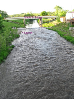
The Walking Bridge Park put-in is down a fairly steep mowed grass hill into some fast water.
The Sportsman Park take out is a concrete boat ramp with nearby parking.
Outfitting:
Boat: 16 foot open canoe, 2 people
Fees:
no
Directions:
Located half an hour north of Rochester, MN.
Launch is in Mazeppa, MN 3 blocks north of Hwy 60 at Walking Bridge City Park at the Maple Street Bridge. Alternate access is downstream left at Herbert Vik off 1st Ave. just above the water treatment plant. Park near the outfield.
The Take Out is located in Sportsman Park just off Hwy 63 in Zumbro Falls, MN
Resources:
"Canoeing the Driftless: A Paddlers Guide for Southern Minnesota" by David J. Lind
Minnesota Gazetter by DeLorme
Minnesota DNR Interactive Water Trail Map has unbelievably handy maps of the entire Zumbro River system including launches:
www.dnr.state.mn.us/watertrails/zumbroriver/
Trip Details
- Trip Duration: Day Trip
- Sport/Activity: Kayaking, Canoeing
- Skill Level: Advanced
- Water Type: River/Creek (Up to Class II)