
Cahaba River in Alabama
Trip Overview
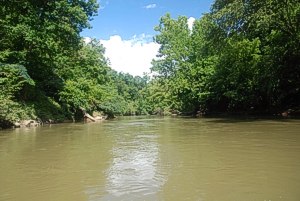
The maiden voyage of THE best Father's Day present ever, a Dakota 14 foot canoe was a 22-mile downriver trip along the Cahaba River in Shelby county near my home in Helena, Alabama.
We put in at the Cahaba River bridge on Highway 52 (Morgan Road) in Helena mid-morning on Saturday 10 August 2013. The water was up some, and flowing nicely, under warm (but not scorching as usual) skies.
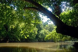
After getting ourselves thoroughly wet, we set out south from the bridge, riding the easy current and negotiating small shoals that required little more than just a paddle or two while crossing. The morning's portion took us past backyards being mowed and quiet tree overhangs that proved to be wonderfully shady rest stops along the way. I took several opportunities to "float," by stepping out of the boat and just hanging and riding the slow easy current...it was glorious!
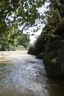
After becoming thoroughly waterlogged, I got back in the boat and paddled easily through wide spots and narrow, dodging a few logs, riding over submerged rocks in the shoals, and stopping to explore a couple of places on the muddy banks. We came across a couple of rope swings which had to be tried, and my son climbed up to oblige, swing far out over the water and dropping in much to his glee!
 Rope swings are a thing of my past, since I'm the "old one," so I watched, laughed, and snapped some great photos of swinging, dragging, dropping, and splashing.
Throughout the day we kept our eyes peeled for wildlife, and we were definitely not disappointed. The Cahaba wilderness is teeming with snakes; moccasins and rat, white tail deer, numerous birds, herons, red shouldered hawks, and noisy ducks when they take flight.
Since this would be an overnight trip, our canoe was loaded down with camp supplies, a dry food container, a cooler, and our personal waterproof bags with dry clothes. The weight proved stabilizing for the canoe, though it did not prove cumbersome in dragging the bottom in places that would normally require portage in the dry season.
 In the late afternoon we sought high, level, and dry ground to set up camp, coming upon a rock take out that led uphill to an established camp site that would have been perfect. This spot was about 11 miles down river on the trip, and would have been the best half-way point. However, since we had taken the entire day to get to this point (it was about 5:30 in the afternoon, we decided to continue on and look some more in order to give ourselves some buffer, planning for the following day's rope swing stops, shoal soaking, floating, swim breaks, and shore exploring.
Truth be told, we probably should have taken that ideal camp site, because all we encountered for the next near hour and a half were muddy banks and inaccessible level ground. We did finally see one spot, pulled in beside a tree, beached the canoe, and forged up the muddy bank slipping and sliding with our supplies and pitched camp on a small piece of level land about 10 feet wide and 12 feet long. This turned out to be a perfect spot, since we always enjoy the places we end up without complaint and thankful hearts.
It had been a warm day, and we were both worn out, sweaty, hungry, and sleepy. A small fire was started to keep the bugs away, though they weren't a problem to begin with (but bring your repellant anyway!), and jambalaya was served with carrot birthday cake for desert! Soon after, we wound down, retired to the tent, and slept reasonably well. During the night the temperature dropped, and we each found ourselves covered up in a sleeping bag before dawn.
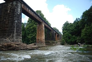 Next morning, following breakfast and a quiet time of just talking, we broke camp, loaded up, baled the canoe, and set out down river. The scenery was just as spectacular as the first day, with the most interesting part of the day given to exploring a side creek and an abandoned railroad trestle.
Back out on the river, we ate lunch under an active trestle, and headed on down towards the take out point. After more floating and more swimming, we arrived at the take out point at River Road (County Road 251) off of Highway 13 south of Helena.
What an amazing and enjoyable maiden voyage for the Gator Vessel!
A big THANK YOU to David Butler of "Canoe the Cahaba" for his advice and suggestions in planning this trip. David knows every inch of the Cahaba and holds a wealth of knowledge of this amazing and precious resource.
Accommodations:
Put in point is reached by portaging steeply downhill to the river's edge.
Take out is a small beach, easily portaged to your vehicle. Be very cautious at the take out point; it is a very popular gathering place and was quite crowded on the day we arrived for take out.
Outfitting:
Pelican Dakota 14 foot canoe, paddles, life jackets
Fees:
No, but permission is needed to park at the put in point.
Contact David Butler of "Canoe the Cahaba."
Directions:
Put in point at the Highway 52 (Morgan Road) Cahaba River bridge. Take out point at the end of River Road (County Road 251) off of Highway 13, approximately 10 miles south of Highway 52/Highway 13 intersection in Helena, Alabama. River Road is not paved, and can be a bit treacherous in the rainy season.
Trip Details
- Trip Duration: 2-3 Day Trip
- Sport/Activity: Canoeing
- Skill Level: Beginner
- Water Type: River/Creek (Up to Class II)