
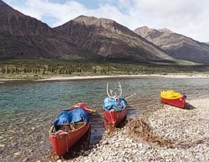
Paddling North!
Canoeing an arctic river is like canoeing a southern river, with these exceptions:
- The water is bitterly cold; a capsize can be fatal!
- There are no trees to help determine distance. An open water crossing that appears to be a quarter mile away may be twenty!
- Rapids can be huge and continue for miles. Rivers tend to be wider and more powerful than those in the south, so moves must be choreographed. A reliable backferry is essential!
A decade of Quetico Park paddling won't prepare you for the far north. It takes time to develop respect for a cold, powerful river - don't rush it! Best plan is to make your first northern trip with an experienced guide. You'll learn a lot and come back smiling!
PORTAGING
In the lake country of the Boundary Waters and Quetico, it's customary to first carry the canoes and heavy packs over the portage, then return for the remaining gear. On a wilderness river, where the trail is unsure, you should reverse this procedure - or better yet, scout the trail before you portage anything. Wilderness portages are neither marked nor maintained, so bring an axe and saw to clear debris. Flag confusing spots with colored surveying ribbon. Last person over the trail collects the ribbon.
Pack in odd units - three or five packs per canoe, not two or four.
This will equalize the number of trips you and your partner make over the portage.
When portaging, do not carry a second pack on your chest! Why? Because falls follow when you can't see your feet. Instead, equip your packs with tumpline's so you can carry everything on your back.
Portaging on the tundra (no trees): Canoes and packs are carried to a distant spot and stacked in a pile. Paddles are placed upright in the pile to act as "flags". Portaging continues from pile-to-pile until everything is across. Important: Choose brightly colored gear that won't blend into the tundra.
Accountability: Every team takes responsibility for the gear in their canoe and inventories it at the end of the portage. To avoid confusion, don't shift items from boat to boat or portage another canoe's gear unless you tell the occupants. Loose items should be secured under a packflap.
MAP READING
Topographic maps are your life-line on a wilderness canoe trip. A GPS is not a substitute for paper maps! Experienced trippers rely on 1:250,000 scale maps (one inch equals four miles); old eyes prefer 1:50,000 maps which provide more detail. Each canoe team should have a set of maps.
Mark the miles: I mark every four miles on 1:250,000 maps and each mile on 1:50,000 maps. I also determine the drop of the river in feet per mile (my book, "Expedition Canoeing" shows the procedure). Generally, a drop of less than 10 feet mile is easy paddling; more than 20 is a probable portage. Of course, it depends on how the drop is distributed-as an decline or a series of falls. Now's the time to back out if the river looks too tough!
GETTING THERE
By Car: Drive the Dumpster highway or Wollaston Lake tote road and you'll see why the most important person on a canoe trip is an auto mechanic! You need high road clearance, two full size spare tires and a bug screen. Trailers should have minimum 15-inch wheels and twin spares plus dust covers for exposed loads.
Floatplanes: Until recently, If you had a party of six, a twin otter was the cheapest way to fly because everything fit inside the airplane. Now, some companies will no longer fly passengers and canoes together. Smaller planes (single otter, caravan, beaver) will carry just one canoe on the floats. Charter fees are computed round-trip from the airplane's base. There's a tie-on fee and fuel sur-charge for a canoe carried outboard. A web search will reveal what planes are available and where. Some companies require an advanced deposit. Nearly all accept VISA.

Charter Boats: If you end your trip on Hudson Bay, the safest plan is to charter a boat to Arviat or Churchill. Bring a CB radio so you can talk to your boat pilot-and get his channel information before you leave home.
Signals: A telephone-sized VHF aircraft radio enables you to communicate with airplanes, up to about 15 miles away. Get your pilot's radio frequency when you book your flight. Orange "smoke signals" are visible for miles - they'll almost always bring a float plane down.
HOW MUCH TIME?
Figure an average of 15 miles per day (tops!) and allow "one day down in five" for bad weather and the unexpected. If you anticipate many rapids and portages, reduce the mileage more. No one will complain about have too much down time on a canoe trip!
HOW MUCH WILL IT COST?
About 80 percent of your cost is transportation. For this reason, a long trip may be less expensive than a short one. You can save big by using folding canoes that will fit inside your chartered airplane. For example, on a Noatak River (Alaska) trip our crew of six eliminated one flight (and saved $2100!) by using Packboats®.
Is it worth the high price to canoe a remote Arctic river? The first time you see a herd of muskoxen or mingle among a thousand caribou, you'll know you've spent your money well!
Cliff Jacobson is a professional canoe guide and outfitter for the Science Museum of Minnesota, a wilderness canoeing consultant, and the author of more than a dozen top-selling books on camping and canoeing. www.cliffcanoe.com
Related Articles

A sea kayaking accident underlines the peril of cold water Watch the video here or read the whole…

Explore the Cote-Nord region in Quebec with Ken Whiting and explore the rugged and beautiful terrain by…

Earlier this year, before Matt, Chris and I headed up to Mendocino, we had the opportunity to spend a…

A discussion on the use of a compass from a kayaking standpoint begins with basic compass savvy and then…