
Maps for the BWCA
Until recently, three major map companies have serviced the BWCA
- Fisher (www.fishermaps.com)
- McKenzie (www.bwcamaps.com)
- Voyageur (www.voyageurmaps.com)
To this list, one can now add National Geographic. Their maps are beautifully executed-complete, precise and accurate. Here's how they differ from the competition:
The entire Boundary Waters are contained on just two waterproof, folded sheets (both sides of the page are printed). Map #753 covers the western half of the BWCA; #752 the eastern half. The scale is 1" = 1.1 miles which, I think, is ideal for trip planning and navigating. Some people, who are used to the 2-4 inches per miles scale of other BWCA maps, argue that this scale is too small. But it's only slightly smaller than the 1:50,000 (1.25 inches = 1 mile) Canadian topo maps you'll use if you canoe in Canada. A scale of roughly 1" = 1 mile allows you to roughly determine distance without using a ruler or dividers.
The printing is typical "National Geographic Society" ultra-crisp, so what you lose with a smaller scale you gain in clarity. Naturally, all the campsites and portages are marked. Contour lines, elevations, magnetic declination information and everything you need to set up your GPS is given. These maps contain everything of importance you would normally find on a USGS or Canadian topo map.
If you use a GPS you'll love these NGS maps because they have UTM coordinates printed on the face, and these coordinates align perfectly with the UTM numbers in the map margins. Canadian topo maps have been doing it this way for decades; American maps are finally following suit. Coordinate-matching numbers enable you to plot a precise fix on your map even if your GPS does not have a built-in map. Voyageur and McKenzie maps also have UTM coordinates but unlike those on National Geograpic maps, the numbers and coordinates don't line up.
Plotting a fix using a GPS is easy. Simply set the unit for UTM (Universal Trans Mercator) and read the satellite fix (numbers on the screen). Then read "right and up" along the map margin, i.e., first plot the easting coordinate, then plot the northing coordinate. You are where the two lines cross. What could be easier? Note: to avoid error you must pre-set your GPS to the correct zone and datum. You'll find this information in the margin of the map.
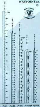
Why not forget UTM and just plot your position as latitude/longitude? Because lat/lon is not a rectangular grid - the distance between longitude lines changes as you go north or south. To locate a Lat/Lon point you'll need to use a plastic "Roamer" (like the one pictured to the right) - it's a hassle, impossible from the seat of a bobbing canoe. UTM coordinates, on the other hand are perfectly rectangular, so plotting a fix is as simple as dividing the distance across a square into 10 equal parts.
Try this practice problem: The UTM numbers on your GPS read: 062910 529120 Plot these numbers on the map below:
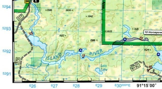
Answer:
You are located at the southeast corner of Lois Lake.
Check out the National Geographic Boundary Waters maps. I think you'll be pleasantly surprised.
Cliff Jacobson is a professional canoe guide and outfitter for the Science Museum of Minnesota, a wilderness canoeing consultant, and the author of more than a dozen top-selling books on camping and canoeing. www.cliffcanoe.com
Related Articles

A chart is not a map. A map just shows you how to get from point A to point B through roads. A nautical…

Let's say you are planning to canoe a river in northern Canada or Alaska. A trip guide, which you got…

A handheld Global Positioning System (GPS) receiver can be an extremely useful piece of navigation gear…
The access point on Lake Monson is at the head of a small inlet on the amoeba-shaped, glacial formed…