
Yellow River in Wisconsin
Trip Overview
The Yellow River... It's beautiful but it's not for everyone...
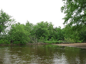
The Yellow River is a lovely stream. Below the Hwy 21 dam in Necedah it runs amber and clear with a fairly swift current through sandy bottomlands and forest until entering Castle Rock Lake about 8 miles later. As you approach the lake the current slows and the river becomes very wide until finally entering Castle Rock Lake north of the Buckhorn Bridge.
The reason I have listed this river as moderate skill level are the many downed trees, some of which may completely block your path. We were forced to portage our 16 foot canoe twice on this trip. Once was over a nice sandy beach but the other was in a fast spot along a steep, crumbly, sandy bank. In addition to these two portages, there were numerous spots where we had to squeeze under or around blockages or scoot over barely submerged tree trunks. Be sure to bring lots of mosquito repellent as the bugs in the downed trees can be quite thirsty when you stir them up.
We put in at the Wastewater Treatment Plant on 9th Street off Hwy 80 in Necedah. There is a convenient gravel launch there. Park on the south side of the parking lot out of the way of the trucks from the Wastewater Plant.
You can also put in upstream just below the Necedah Dam on the west side of the river at Hwy 21. Carry your boats down the riprap and take advantage of the only real drop/riffle on the river just below the dam. Both of the launch spots in Necedah are free.
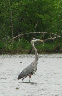 After you leave the stretch of riverside homes in Necedah the environs become quite wild and peaceful. We saw many turtles, bald eagles, a golden eagle, frogs, swallows and even a nesting pair of rare and endangered cranes that made quite a ruckus as they flew off. There are constant oxbows and backwaters connected to the main channel. Many downed trees require maneuvering.
The overhead wires supported by two poles are in Necedah. The single pole power lines are a little more than halfway to the Crappie Point take out (off Hwy 80 at 32nd St).
Not long after the single pole power lines you will enter the Yellow River Wildlife Area (http://dnr.wi.gov/maps/WM/WCR/7262buckhorn.pdf) and the current will slacken. This area is a good place to see marsh wildlife.
Take out at Boat Launch D, Buckhorn State Park (Crappie Point):
www.dnr.state.wi.us/org/land/parks/
You will need to have a WI State Park sticker at Launch D.
Sticker Prices: http://dnr.wi.gov/org/land/parks/fees/
If you do purchase the State Park Sticker, be sure to visit nearby Roche-a-Cri State Park.
www.dnr.state.wi.us/org/land/parks/specific/roche-a-cri
You may be able to find somewhere else to take out that does not require a fee. There are many other fee sites nearby if you wish to extend your trip a bit farther into Castle Rock Lake.
When we did our trip the river was at 260 cfs at the USGS gauge at Necedah, which created a nice current but not too fast. At much lower levels this river would probably not be as enjoyable due to the many downed trees and shallow sand bars that would become impassable.
If you don't mind the occasional portage, this river offers many attractions. The beautiful sandy bottom, the turtles, eagles and cranes, the peaceful setting and the convenient accesses all make this trip worthwhile for an afternoon paddle.
The shuttle route is 6.1 miles, not too far to bike.
It is 7.6 river miles from the Necedah Water treatment plant to Crappie Point (launch D)
Time: We did it in 3 hours but allow more time if you prefer a leisurely paddle or will take swim breaks.
Additional:
Another nearby attraction not to miss is The Necedah National Wildlife Refuge. They have butterflies, cranes, deer, and countless bird species that inhabit the 44,000 acre refuge. A nice, big, brand new visitor center just opened up April 2011. Don't skip the boardwalk marsh trail.
Accommodations:
Shipwreck Bay on Hwy G has a great menu, including pizza, ribs and more. They have a fantastic $10 all you can eat walleye special on Friday night.
Buckhorn Bar & Grill, also on G, has a $13 all you can eat Pig Roast on Friday and Sunday nights.
Fees:
WI State Park Sticker if you park in one of their lots.
Directions:
Take exit 61 (New Lisbon) off I-90. Go north on Hwy 80 to Necedah, WI.
Necedah is located about a half hour north of the Wisconsin Dells.
Resources:
Yellow River map:
www.juneaucounty.com/content//media/media1362.pdf
Yellow River Water Level and Streamflow information:
waterdata.usgs.gov/wi/nwis/
Trip Details
- Trip Duration: Day Trip
- Sport/Activity: Kayaking, Canoeing
- Skill Level: Intermediate
- Water Type: River/Creek (Up to Class II)