
Upper Missouri River in Montana
Trip Overview
 These are excerpts from my journal of a trip from Fort Benton to Judith Landing.
This trip started on a down note, since we were due to leave the weekend after September 11. We had to delay our trip a day because the airports were still closed and even when we did leave we had a lot of difficulty getting from Jacksonville, Florida to Great Falls, Montana.
We had outfitted with Sid Napier, from Starwest Adventures and he was very understanding and agreed to shift everything a day. Sid had also been very helpful with the travel logistics. We decided to stay in the Heritage Inn in Great Falls before leaving on the trip. They have a shuttle from the airport and we were able to prevail upon the driver to take us to K Mart on the way to the hotel so that we could get some Coleman fuel.
September 17, 2001
There was a nice restaurant named Elmer's next to the hotel where we had breakfast the next morning. Sid picked us up right on time and we headed off to Fort Benton, our put in spot. We unloaded at the ramp and went to the BLM office and checked in and got maps. Five minutes later we were off. What was clear right from the beginning was that we were going to see some wildlife & we were going to make good time. We knew the wildlife since there were deer crossing the river almost where we put in and then came the geese. The good speed was easy to see by how fast the bank was speeding by due to the current. The place is very arid and there is little vegetation. Some places there were eroded bluffs and other places were more level country. Most of where we went today was private land for running cattle. One other difference from my previous trips was that I had my GPS. For me this was great since for the first time I really knew where we were most of the time.
We passed all our waypoints constantly scaring up geese, white pelicans and ducks. We saw lots of deer as well. The river is pretty shallow and many times we rubbed bottom and several times had to get out & push us to a channel. As time went on Phil was able to read the river better & we could avoid some of the trouble.
Mile after mile went by & we passed the campsite we had planned in favor of one Sid told us about across from the Marias River. He also told us about Decision Point overlook where L&C had to decide whether to proceed up the Marias or Missouri on their way to Great Falls. They picked the right one, but for us we had more of a problem. We stopped, but couldn't find any campsite. We decided to keep going and about 4:30 stopped on an island that has had few campers and set up. It was a long day, but I feel good. We went 26-27 miles, so rather than have our long day tomorrow - we've already done it. The place is a little primitive, but we both have pretty good campsites. We cooked and had a nice fire & then the stars came out - tons of them. We had thought about getting a star chart, but kept on forgetting, so now we just had to guess.
 September 18, 2001
Today was a pretty easy day. We were off early and ran into a lot more shallow water where we had to get out to pull the canoe. At first I wanted us to be clever enough at reading the river that we wouldn't have to do this, but after a little while I realized that we would have to concentrate too hard & we would miss the scenery - so I told Phil let's just take it as it comes. He was all for that. We saw a huge fish - probably a carp in the shallows with it's back out of the water. We also saw a bald eagle to go with the golden eagles we saw yesterday. We also saw a really nice group of antelope. Both Phil & I used our glasses, but forgot to take pictures.
We made pretty good time to Virgelle Ferry, but didn't think this was where we would get out to go to the mercantile I had read about. We thought it was around the bend, but couldn't find it. We did eventually spot some buildings and decided to go on the shallow side of an island and boy, was I glad we did since it turned out that it was Coal Banks Landing campground. We needed to stop here since it was the only place on the trip where we could get water. We decided to stop and relax a while. I ate lunch and read more of River Horse. I was reading the section about where we were - his midnight walk from Little Sandy to Virgelle because the BLM boat broke down. We decided we would go to Little Sandy and check it out or if we wanted to press on to Eagle Creek. Thanks to my GPS, which I have loved for this trip, we found Little Sandy. It's a pretty nice camp and we chose a flat field to set up, but it wasn't even 2:00, so we just kicked back & read, rested, etc.
About 5:30 we decided to go for a walk, but everything was fenced in, so I decided to make dinner. Phil decided to try along the river. I was nearly done with cooking my dinner when I looked up on a high hill and saw something. I thought it might be Phil so I got out the binoculars and confirmed. It turned out he had to jump a fence to get there, but soon I was on a steep climb to a wonderful view. You could see mountains in one direction, the river in another and mostly barren land in between.
We came down and both had dinner. We didn't camp where the fire ring is, so no fire tonight. We both turned in early to the sound of coyote songs.
September 19, 2001
Things are a bit different today. I'm writing this in the Hole in the Wall shelter while it is raining outside. We got a good start this morning, probably on the river by 8:30. We heard coyotes all night last night and this morning they were quite close. The river was quiet which we were glad of since today was to be a windy day. We went along smoothly with only a few wind gusts and made our way to LaBarge Rock. Across the river was the Eagle Creek campground. This is where we would have stayed had we not stopped at
Little Sandy.
There were two guys there packing up their canoes. We said "hi" and a little later they told us of a nice walk up the Eagle Creek coulee to where some petroglyphs were. We decided we had enough time and took a nice walk. There was an igneous "curtain wall" there that was a pretty distinguishing feature - L&C called this place Stone Wall Creek because of that. We went further up the valley and saw some really nice formations, but no petroglyphs.
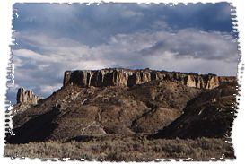
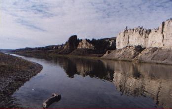
We had started passing the White Cliffs earlier in the day and were pretty impressed. I thought the White Cliffs would line both sides and we would be in a narrow canyon, but this was not the case, since it tended to be more of what we have seen so far, high on one side low on the other. After a while past Eagle Creek they seemed to have been replaced by more conventional scenery. The wind picked up quite a bit and we found ourselves several times paddling quite hard not to be swept to one of the banks or shallows. We stopped for lunch on the bank and a guy in a motor/drift boat came by. We figured being ahead of us with a motor we wouldn't see him anymore. However, it seems he would stop and take photos. We passed him and soon found Hole in the Wall. The site is quite barren - no trees so they have very nice three sided shelters with fire rings - but very little wood. We decided to not sleep in our tents, but just sleep on pads in the shelters. However, hardly had we gotten our stuff in than it started raining. Not hard, but off and on, continuing for an hour. Looks like it has stopped for now which is good since we wanted to take a hike!
************************
The afternoon got pretty nasty - rain and high winds - dust blowing everywhere. By 4:30 though it had cleared up enough for Phil and I to take a hike. We wanted to go up to one of the high hills around the campsite for the view. There were several ravines that blocked our progress up the hill we wanted, but we got to another one. It had spotted rain for a while and was quite windy. The top gave a great.
 September 20, 2001
Today was a very nice day. We both woke up early - just before sunrise since the shelter was facing east. A chorus of coyotes sang out to wake us - who needs a rooster? The weather was great and the wind calm. We were on the water before 8:00 and making good time. We got to Steamboat Rock and Dark Butte fairly early, so decided to stop and hike around. There were some really interesting formations and we spent a good while there climbing around and taking pictures.
We took off again, but by 11:30 we were ready for lunch so we pulled over under some cottonwoods. These, like so many of the cottonwoods, had been attacked by beavers. It seems no matter that these are huge trees, they'll try to fell them if the tops come pretty close to the water.
Off again, but before we knew it we were at Slaughter River & our stop for tonight. We were here around 12:30, but that was OK because we planned to do some hiking. We first went across the river to Slaughter River to check that out since L&C said it was so beautiful, but for us it was a kind of bust, with two cattle ranches in front & then the river was bone dry. We picked up some firewood from old beaver lodges & and ferried them back across. About 4:00 we took off for the hills above camp. We wanted to get to the top, but the area was cut with ravines. We want as high as we could, then I went back the way we came up and Phil took a different route. I then went over to another set of hills trying to get high. I followed an animal trail & got pretty high. I could have made it all the way to the top on this route, but the slope was steep & the footing loose, so I came back down. When I did I saw that there were others in the camp.
Phil had already met them, Jim & Dean.
We had dinner and afterward went over to say "hi". Dean was a physicist and Jim a metallurgist, both retires. We had a nice chat. Dean is into berries and gave us some of his award winning wasaba - pounded & dried choke cherries. This was something L&C ran across that some of the Indians ate.
Both Phil and I are sad this is our last night out.
September 21, 2001
I slept like a log last night & slept in enough this morning that Phil was up before me. Dean & Jim were up too and had started a fire. We could have used a fire because it was pretty cold.
We were off a little after 8:00, but it was overcast and chilly. This put a bit more of a somber mood on the finish to our trip. There were more rapids today, but the scenery wasn't as spectacular as days past. We also lost the high bluffs & with that the chance to see a mountain sheep.
We made it to Judith landing at 10:35. Sid had told us that there was a general store there & we could get Amy to call him. However, when we got there an old BLM guy came out of the trailer and told us the general store was closed. It took some talking, but we finally got him to let us use the phone to call Sid. Sid couldn't come until 12:00, so we packed up and had lunch. After lunch we also went down and talked to the guy that had been in the boat we had seen on Wednesday and had tied up at Hole in the Wall. He was actually an artist taking photos to use later for his oil paintings. We talked to him for quite a while & then we saw Dean & Jim coming down the river and Sid over the bridge to the landing.
It was a pretty long trip back to Great Falls, but we had a nice talk with Sid. He takes some pretty big groups on trips and has all kinds of folks.
We were back early enough to go to the L&C Intepretive Center. It was really great, especially after being on the river right before. It is amazing how much hard work it was for their trip. The hotel driver had taken us over & was late picking us up because of a flight coming in, but we were soon back to the Heritage Inn. We went back to Elmer's for dinner I had a great steak.
What a great trip!
Outfitting:
Sid Napier from Starwest Adventures. We rented a canoe from him and a shuttle from Great Falls to Fort Benton and Judith Landing back to Great Falls.
Resources:
BLM Maps and books on the Upper Missouri. Also reading William Least Heat Moon's "River Horse" is great background.
Trip Details
- Trip Duration: Extended Trip
- Sport/Activity: Kayaking, Canoeing
- Skill Level: Beginner
- Water Type: River/Creek (Up to Class II)