
Placer River in Alaska
Trip Overview
 The Placer River is a beautiful little river (or large creek) that travels from Spenard Glacier north until it empties into the southeastern corner of the Turnagain Arm. The valley formed by the river is a beautiful section of the Kenai peninsula, a section through which there are no roads, so the only way to access it is foot, kayak, or train (if you want to pay $157.00).
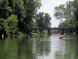
The easiest put in is underneath Highway 1 at the Placer River bridge. From this primitive (gravel) boat launch you can turn south and paddle upstream into the Placer River delta. The river abounds with fish, waterfowl, and moose, and though I've never seen old Ursus Horrilibus here, his tracks are all over both banks so you might want to bring some bear spray (or something stronger?).

Anyway, as you proceed upstream you will go through a variety of terrain. Most of it is smooth and easy to paddle against the current. There are however, some stretches where you must get out and portage over a steeper area. These are few and easy to get around though.
It�s about a two to three mile deep delta, which you can traverse any way, so long as you keep heading upstream. As you get further upstream you will notice the geology gradually changes from Turnagain Arm mud to stony glacial sediment. Eventually you will clear the delta and come to the main channel of the Placer River.
If you're not at muscle failure yet you can continue on up to Luebner Lake (a lake formed by the pooling of the glacier melt) or all the way to Spenard Glacier (this will require significant portaging though). If not then just turn your boat around and enjoy cruising at 6-10 mph back to the bridge where you put in.
This trip is an outstanding workout, and the only way to view the very scenic Placer River Valley without paying.
Comments:
Just a warning......unless you are looking for a creative suicide method, do not, do not paddle under the Placer River Bridge and out into the Turnagain Arm. With its massive tidal flux, huge bore tides, and quicksand like mud, the Turnagain Arm is not for the kayaker with hopes of returning without a cost guard rescue chopper.
Accommodations:
Not much. This route is straight up wilderness, but it�s not to far from Girdwood and Whittier, which have all the facilities you would need.
Fees:
None.
Directions:
From Anchorage, simply proceed south on the Seward Highway (HWY 1) all the way down the Turnagain Arm. As you get to the end of the Turnagain Arm (a little past the exit to Whittier) the road will turn west and you will go over a bridge labeled "Placer River". There is a parking area immediately on the other side of this bridge.
Launches:
The put in is right by the parking area, which is next to the placer river bridge. It consists of a gravelly boat ramp eaten away by the tides. Just fine for kayakers, but powerboaters should be careful.
Contact:
This area is a part of the Chugach National Forest, so any of their offices might have some info.
Resources:
A topographical map of the delta and a GPS and or excellent orienteering skills will be required so as to not get lost in the delta. (There is no real danger to being lost however, as by simply turning your boat around and drifting with the current you cannot fail to arrive back at your put in).
Trip Details
- Trip Duration: Day Trip
- Sport/Activity: Kayaking, Canoeing
- Skill Level: Intermediate
- Water Type: River/Creek (Up to Class II)