
Lumber River in North Carolina - Extended Trip Report
Trip Overview
 The Lumber River, a black water river in the southern part of NC, begins at Scotland County, SR 1412, or Turnpike Rd and runs approximately 133.4 miles to the confluence of the Little Pee Dee River below Hwy 9 South of Nichols, SC at a landing called Fork Retch. The mileage in NC is 115 miles, which was added to the NC Scenic River System in 1989, which also became the Lumber River State Park. 81 miles of the River were accepted into the National Wild and Scenic Rivers System in 1998. The name of the Lumber River is derived from the extensive timber harvesting and transportation done in the late 1700s.
Last year, Feb 03, when Wayne Charles, Myron Whitley, and myself, all members of the Lumber River Canoe Club (LRCC), paddled the entire Black River, we discussed doing the entire Lumber River in one trip. After plans were made we finally met on Saturday, 21 Feb 04 in the morning, at the boat landing on Turnpike Rd to begin our adventure. Wayne from Lexington, NC, riding with Myron from Winston-Salem, NC arrived before me and came the longest distance. After unloading our two trucks, Myron and I were off to the house of the person who was doing the shuttle for us and keeping our trucks, Marshall Thompson also of the LRCC. Marshall brought us back along with other members of the LRCC who were doing a day trip. It should be noted that I was getting a lower reading of mileage on my GPS as I understand this is a quirk of using a hand held GPS, so I will try and use the mileage from Paddling in Eastern North Carolina by Paul Ferguson, which is an excellent source. Some of the mileage may also vary because of the high water and the ability to take cut thrus or short cuts.
DAY ONE -FEB 21, 2004 THE BEGINNING OF THE LONG JOURNEY
Our three solo canoes fully loaded with gear and Myrons dog Isaac in his canoe, we put in at 1010am. The gauging station upriver on Drowning Creek near Hoffman, NC read approximately 275cfs at 4.8 ft. Meaning we had a good current. Around 1230 we stopped for lunch at Chalk Banks with the day-trippers and another set of paddlers. At Hwy 401 boat landing above Wagram, NC, a distance of 8.3 miles, we left the day paddlers around 1:45 pm. We finally arrived at our first night camp 6.5 miles, Jasper Memory Canoe Campsite, a rustic campsite with a picnic table and fire ring. This a Lumber River State Park canoe in campsite and as the others sites, no charge. During the trip this date we saw deer and bird life and did not have any portages due to high water level. What is any canoe trip without the before dinner beverage and a good plate of hors doeuvres of port wine cheese and crackers. All the dinner meals were planned and we had decided on four meals cooked over charcoal and the other dinners we divided up. The breakfast meals we all took turns and created the menu. That night we all had steaks and some other menu item; salad, veggies, potatoes, etc. After dinner we sat around the fire wondering what the next days would bring as far as portages, weather and sites. We traveled 14.8 miles the first day.
 DAY TWO FEB 22, 2004
After waking up and having our coffee near the fire, it was decided that I cook breakfast. I cooked fried eggs to order, grits, and side meat. One disadvantage about cooking breakfast is that while you are cooking everyone else is packing up leaving a person wondering if this is an eat and run type of thing. Naturally after breakfast and cleanup I had to pack up and Myron and Wayne sat there relaxing. My day will come. I knew I was going slowly when I was almost done hauling things to my canoe, when Wayne walked over and asked if he could help. Should have asked an hour ago! We finally got on the water around 0930 am and the first thing we saw was a beaver on the bank watching up go probably saying good riddance. We finally reached section 3 of Fergusons book at McGirts Bridge at 1100am. 1.7 miles below McGirts Bridge is a high piece of ground on the right called Skeeter Lake, which is a good lunch place, and we took advantage of it around 1145am. We reached Hwy 71 above Maxton, NC at 1:37 pm and took a break. At this bridge is the water gauging station, which read about 900cfs at 10.2 ft. Plenty of water to go over or around downed trees. We crossed Old Red Springs Road at 2:51 pm and Alma Bridge at 3:57 pm having gone 15.5 miles. We crossed under a major East/West railroad bridge at 4:21 pm. As darkness approached we started looking for a place to camp in the swamp and found such a site. It was on river left back in the swamp a piece of high ground with pine trees on a little island. We had to wade in ankle deep water to get in and pull our boats, as the water was shallow. That night we decided to cook over charcoal again and steak and pork chops were cooked after the usual pre dinner hors doeuvres and beverages. After sitting around the fire we all hit the bags only to listen to the trains in the distance all night long. Distance traveled this day was 17.3 miles (15.9 miles on my GPS).
DAY THREE 23 FEB 04
Wayne had his day cooking breakfast with link sausage and walnut pancakes. The first pancake was probably the best and then one in between was good with the last pancake, well it was edible. Wayne get a bigger spatula next time. This time I had my day of sitting around while Wayne packed up. We left camp at 0935am and paddled to the Indian Culture Center (Robeson County SR 1354) making it there for a break at 1110 am. 2 miles from the Culture Center we stopped for lunch 1215pm. At 1:11pm we passed Harpers Ferry Church and bridge (NC Hwy 710). 2 miles past this bridge is Tree Island where camping is possible on river right. We made it down to Chicken Road Bridge (SR 1003) and started looking for a campsite. Approximately 100 yards down from the bridge we found a high site on river left and made camp. We traveled 15 miles this day. After the usual pre dinner snacks and drinks, Myron cooked chili and baked corn bread.
DAY FOUR 24 FEB 04 FINALLY MADE LUMBERTON, NC
After breakfast of cinnamon oatmeal and country ham prepared by Myron, we left camp at 0850am. We crossed under Lowe Rd (SR 1550) at 1038am. Almost 4 miles after the bridge we stopped for lunch on river right where Back Swamp enters the river. After lunch we came to Tom Avent Landing, a Lumber River State Park canoe campsite after 3.3 miles on river right. It was too early to camp, 2:08pm so we paddled on. We arrived at the Kenric Dr (SR1539) at 2:48pm after 15 miles. The section above Kenric Dr. is downed with trees and will be tough if water levels are lower. We were shooting for McMillans Beach, at Lumberton, NC, for a campsite. From Kenric Dr. on down I-95 traffic is heard as it is only about a half mile and less from the river. We finally made McMillans Beach at 3:55pm and set up camp. Most of the day was paddled in a light rain. We had traveled 17.8 miles that day however I had 14.1 on my GPS. A quick call to Rudolph Floyd, another LRCC member, and we had a shuttle to get water and ice. Wayne cooked red beans, rice, sausage and Myron cooked corn bread and for desert, apple cobbler. This campsite is a locked park operated by Lumberton Recreation Dept and is within site of I-95 and has a picnic table and fire ring. Make it a point to bring earplugs if you stay at this site as the traffic runs all night long.
 DAY FIVE 25 FEB 04 LEAVING THE NOISE BEHIND
My turn again for breakfast and it consisted of western omelets, side meat, and grits, and of course always coffee. This was to be what we planned as our longest paddle day as we were going to try and make Buck Landing Canoe Camp site. We left McMillans Beach and paddled almost through downtown Lumberton without notice getting quieter each stroke away from I-95. We passed the Lumberton Gauging station, which read 11.8ft at 1500 cfs. This gauge came from the website however when we read the physical gauge in the water it read 10.5 ft. We came to the boat landing at Hwy 72 after 5.6 miles. Before getting to the landing on river left where the river bends is a high hill, called what else, High Hill. Fossils can be found in the hill. After about 6 more miles, we stopped for lunch at Horse Bluff Landing, a piece of land owned by Charles Hickman who always welcomes paddlers for lunch and even camp if needed. We came to Mathews Bluff Rd after a total of 14.9 miles paddled. The water was high and we had to get really low in the canoes to get under the bridge. It seemed the middle of the bridge got lower and I pictured us getting stuck until the water dropped. We made Willoughby RD (SR2121) or known as Phillips Bridge at 3:00pm. Buck Landing Canoe Camp site was a welcome site after 21.6 miles at 4:05pm. It has two picnic tables under a shelter and a fire ring. Myron had heard on his weather radio that a wintry mix of sleet, snow, ice was coming in that night so the shelter would help if we need it to cook under. Wintry mix, what a word that we did not count on when we first started on this trip. That night after the drinks and snacks, I cooked spaghetti with Italian bread that I had been cradling like a baby the entire trip so it would not get smashed.
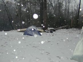
DAY SIX 26 FEB 04 WINTRY MIX!
Snow, sleet, and freezing rain, in that order. That is what we awoke to this morning. I always wanted to camp in the snow but not what was to come later. After getting the coffee going and drinking several cups discussing our strategy, we ate breakfast of pancakes and side meat cooked by Myron. We left camp at 0945am hoping to make the Lumber River State Park by days end. We reached another primitive canoe in campsite called Piney Island after about 2.2 miles and we had to stop and bail water out of the boats. The snow turned to sleet and then rain. We reached the boat landing at Hwy 74 near Boardman, NC around 1140am and had a quick lunch while bailing water out of the boats again. Water level at Boardman was 6.9 ft at 2100 cfs. We had contacted the park Superintendent James Sessoms and asked to use the park picnic area to cook and of course with weather like this he said it was not in great demand and we were welcome. We finally made the Lumber River State Park at 2:20pm and loaded everything to the picnic shelter. We had come 13.8 miles that day. At night we tried to dry stuff out, clothes, tent flys, etc. Myron cooked beef stroganoff and we were visited by Ranger Neil Lee and then by Marshall and Charlotte Thompson, our shuttlers. I think they wanted to see if anyone was ready to end the trip but we had come too far to get out now. Thanks to the Lumber River Park rangers James Sessoms, Neil Lee and others who were very accommodating in our visit.
DAY SEVEN 27 FEB 04 LAST DAY IN NC
We woke up to rain and were able to cook breakfast under the picnic shelter. Wayne cooked grits and country ham and we had a send off by Ranger Lee in the rain around 0855am. It was a cold and freezing rain all day and not too many pictures were taken but just paddling trying to keep the feet warm. We reached Fair Bluff, NC at 1220pm 11.3 miles, and ate a fast lunch in the rain walking around the Riverbend Outfitters parking lot. Myron and I wanted to walk up town and get a hot cup of coffee to warm up but when we looked around, Wayne had already put in and was paddling like a mad man down the river. We left behind him not being able to catch up until we got to the SC line, which is approximately 3.4 miles from Fair Bluff. The line is marked with a 2 ft high concrete marker on river left. Someone has put a sign in the tree above the marker. We reached our last night camp at Watermelon Bluff on river left 19.2 miles from the Park. Since it was cold and wet we built a fire and the put a tarp to put our gear under. Wayne set his tent up in the rain and by time Myron and I waited it was sleeting. The weather cleared and we grilled steaks our last night and watch the stars and moon come out meaning it was clear and going to get very cold.
DAY EIGHT 28 FEB 04 LAST AND BEST DAY
When I say best day I do not mean that it is the best day because it is the last. I mean the weather was great that day for paddling. We woke with frost on the tents, ice covering the water bucket, and Myrons socks that he left out to dry looked like they had sneaked a couple of tabs of Viagra. I mean they were frozen stiff. I cooked eggs, country ham and hash browns. We sat around the camp like we had nothing to do that day. The temperature warmed up and we were thinking that today we would end the trip. We had originally planned a 9-day trip or possibly a 10-day trip but due to the high water and good current we were lucky. We finally broke camp and left at 1020am. At mile 6.9 from camp, NC an old railroad bridge crosses the river with a center swing section. This was to let boat traffic get through when riverboats ran this section and the old gear is highly visible. We reached the Hwy 9 Bridge near Nichols, SC at 1:09 and I called Marshall to see where he was with our trucks and let him know our progress. We passed the furthest point South I have paddled on the Lumber River, Rice Field Cove Landing at 2:37. This is the first boat we saw on our entire trip other than our own. We got to the confluence of the Little Pee Dee River, which enters the Lumber on the right, and the end of our trip at 2:37pm. We still had another 15-minute paddle to the landing at Fork Retch where Marshall and Charlotte were waiting with our trucks. As I said the total trip was near 133.4 miles
This was a great trip on a beautiful river despite the weather. Some of you ask why do we go this time of year. Well, there are no bugs, water is higher and it pushes us to the limit to see how much wool, polypro, gore tex, clothes, gloves, we can get into a canoe, and dont forget the food, hors doeuvres, coolers, and the drinks. We saw a variety of wildlife, including deer, beaver, owls (heard a bunch too), white ibis, blue heron, gazillion ducks and many other birds. If the water level was lower we might still be on the river as there were a lot of trees down on the upper sections. Many thanks go to people who helped us on this trip, Marshall and Charlotte Thompson for shuttling the trucks, Rudolph Floyd for helping us get ice and water, and if we knew if was going to be cold the last three days we would not have needed ice, and also a great thanks for the Lumber River State Park staff of James Sessoms, Neil Lee and the other staff. Where are we going next year guys? Warmer month of course. Final footnote, Wayne collected 84 fishing bobbers, a new record.
Outfitting:
3 solo canoes; Mohawk Challenger, Mad River Guide, Old Town Penobscot
Directions:
We put in at Turnpike Rd between Scotland and Hoke Counties, NC, State Road 1412, 8 miles East of US Hwy 15-501. Take out was at Fork Retch in South Carolina 2 miles west of Hwy 76 South of Nichols, SC.
Resources:
Paddling Eastern North Carolina by Paul Ferguson
DeLorme North Carolina Atlas & Gazetteer
Paddling South Carolina by Jack Horan and Gene Able
Hoke County, Scotland County, Robeson County NC maps, SC state map.
Trip Details
- Sport/Activity: Canoeing
- Skill Level: Intermediate
- Water Type: River/Creek (Up to Class II)