Reading the Weather
As a fish o'er whose head surge the waves of the sea, In our great sea of air, the fish becomes me. And high o'er my head waves of air churn and roll; Deep currents, deep tides move the air, move my soul. - Don Haggerty "Rhymes to Predict the Weather"
I headed out on a long, twelve-mile paddle to the outer islands that protect the island of Kodiak from a 3,000-mile fetch across the Pacific Ocean. The sky was a cloudless blue; the water (yup, you guessed it) smooth as glass! Confident of the stability of those conditions, I could circumnavigate along the outer ring of rocks and reefs so I set out without even consulting marine weather. My eyes were my weather station; too bad my brain wasn't also.
Rounding the last rock I felt a subtle hint of things to come. A very subdued but cold breeze pecked me on the cheek. A faint ripple sidewinded its way across the water in front of my boat. Within five minutes the sky began filling with sinister looking gray clouds. Within ten minutes, calm seas and gentle breezes had evolved into two foot waves and blowing 12 to 15 knots. I set my sights on a channel buoy about half way across and hunkered down for the straight-line paddle. Within five minutes the wind, now exceeding 20+ knots was ripping the tops off of waves in long strands of mare's tails. I reached the buoy and grabbed on to a huge eyelet welded onto its side. Another half mile and I could sneak in behind the islands flanking the channel along the town side of the bay. I vowed to check the weather report the next time I ventured out. Lesson learned.
You don't need a lot of equipment to be able to make fairly sound weather predictions - especially if you know a few basic principles and can read the local skies (and often animal behavior and other physical signs). At least you should know when the meteorological yellow flag is waving.
Before getting into an overview of "weather", let's all make sure we're on board with the same definitions:
Weather - the conditions and characteristics of the atmosphere at a given time Climate - weather conditions over a period of years Wind - the horizontal movement of air Current - the vertical movement of air.
TAHE 10'6 & 11'6 SUP-YAK Inflatables
2-in-1 Kayak & Paddle Board complete packages for single or tandem use.
General definitions of cloud shapes/types are also handy, especially when trying to predict upcoming weather. First, we all know what a "cloud" is, but here is the technical definition: visible aggregate of minute particles of ice or water (< 100 microns).
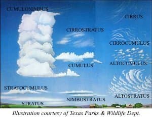
There are three basic categories of cloud formations, combinations of which form ten overall types:
- High clouds Cirrus (horsetails) Cirrostratus: thin veil of ice crystals (form a halo around sun) Cirrocumulus: tiny cotton balls or rippled sand.
- Middle clouds Altostratus: light gray veil that almost blocks the sun. Altocumulus: lumpy, like a flock of sheep.
- Low clouds Cumulus: puffy clouds Stratus: straight, layered clouds Stratocumulus: puffy clouds, clustered, not fully separated nor completely layered either. Nimbostratus: dark clouds not usually visible from directly below
In very general terms, the high clouds tell of upcoming weather - those ice crystals are from moisture in the air generated by distant storms often meaning fair weather further down range. Low clouds are generally a manifestation of current weather in the immediate area. The middle range clouds are indicative of the "weather" over a greater area or region.
Air, Pressure, etc. Changes in the air's temperature affects how it moves. Warm air rises forming a partial vacuum that creates a low pressure at the surface of the earth. That rising air begins to expand and get cold (often forms clouds). Conversely, as that air starts to sink again, it warms up and starts to pile up at the earth's surface thereby creating high pressure. Those shifts in pressure are measured with a barometer. Winds blow from high pressure to low pressure.
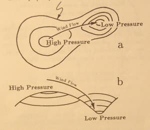
Lines of equal pressure around either a high or low area look like a contour map. Those lines are much closer together around a low pressure area. Since the air flows from high to low it flows from the wider contours to narrower ones, creating higher winds because of the steeper, downward slopes of those narrower contour lines. (See diagram).
Besides temperatures causing air to rise, obstructions on the surface do, too (i.e. mountains). Fronts are created when two air masses collide - the heavier, cooler air forcing the lighter, warmer air to rise up over the cooler, heavier mass.
Generally then, higher pressure means drier, warmer conditions; lows mean rain, winds, etc. Highs circulate winds clockwise; lows circulate counter-clockwise.
Here's a handy rhyme to remember what to expect from high vs. low pressure areas:
Tighten a bolt, increase the pressure Loose a screw, pressure is lesser. Tighten it swiftly for fair weather wind, Loosen it quickly, fierce storm to begin. - Don Haggerty "Rhymes to Predict the Weather"
Mother Nature's Weather Forecaster:
Low pressure causes insects and birds to fly lower than with high pressure; bees tend to be more active before fair weather. A vertical column of smoke is a sign of fair weather whereas smoke that tends to flatten out indicates poor weather. Odors are more noticeable and sound seems louder and sharper in low pressure air. Here's another rhyme to help you predict the weather:
When the dew is on the grass, rain will never come to pass. When the grass is dry at morning light, look for rain before the night! - Don Haggerty "Rhymes to Predict the Weather"
Halos around the moon and sun are also good indicators of impeding weather. A halo or "sun dog" usually means rain before the night is done. A "moon dog" can mean rain by the following noon. Sharp, clear images of the moon, and bright, twinkling stars means there is little moisture in the air.
Of course, every school kid is taught: "Red sky at morning, sailor take warning. Red sky at night, Sailors delight!" Red skies means there's dust in the air to the west. This is a sign of dry air that's coming at you (red sky at night). However, if you are looking through a red sky to see the morning sun, that usually means the dry air has passed over perhaps being pushed by moisture laden air over you.
Winds
Like several of these weather elements, entire chapters are typically written about wind. From a safety standpoint, knowing all the ways winds can be generated is important. We've already discussed how temperature, obstructions and other weather elements affects the movement of air (wind). From a boater's perspective here are few types of winds that can have an adverse affect on you.
Anyone paddling where there are high, sheer bluffs, cliffs or steep mountains adjoining the water's edge should be aware of williwaws. These are winds that literally spill down off of the high country like water overflowing a sink. A basin high in the mountains fills with cold air to overflowing. That air then spills over and rushes down the side of the mountain or down over the cliff and out across the water. These sudden gusts can come out of nowhere and cause an unsuspecting and unready kayaker to capsize.
Surges can occur when high winds push high waves inland. This can create dangerous surf zones as well as damage to tidal areas on shore. Checking tide tables and watching the weather and wind build will help you be on the watch for surges.
Remember, too, that during the day, as the sun heats air over land, the sea is cooler. This causes the cooler, sea air to flow in to replace the rising, warm air over land. At night, the land cools faster than the ocean and the wind shifts to flow back out to sea.
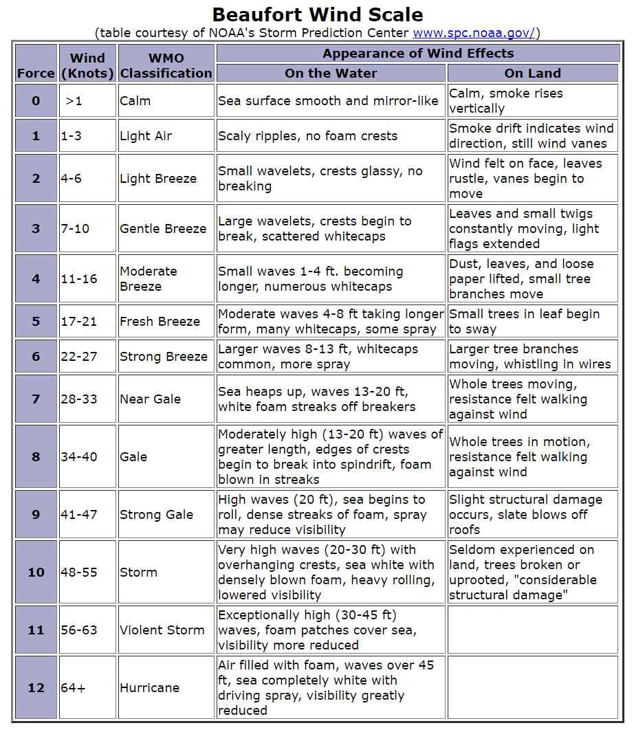
Whatever wind confronts you, its good to know its relative speed, perhaps to make some course alterations or trip decisions. The Beaufort Wind Scale is an old mariner's chart developed a couple hundred years ago to determine wind speed based on 12 stages of wind velocity as it affects waves and objects on land (bending trees, waving flags, etc. - see table at end of article).
Learning weather signatures and what to expect will help you make safer decisions when it comes to planning on on-water activities, course selection and alternate planning needs. A good marine-band weather radio is an essential piece of equipment for even an afternoon on the water. Smaller, wristwatch-sized compasses with a barometer are also a good bet, especially those that will track readings in eight-hour segments to show changes in rate and amount of change in pressure. Be a weather savvy kayaker!
Related Articles
This a follow up to a video I did where I talked about differences that you may find in dry and semi-dry…
Can you use a Greenland Paddle in a Recreational Kayak? I received this question recently from a…
Learn how to stay comfortable on the water when fishing in the cold. When you stay warm and…
Several columns ago ("Sea Kayaking's True Colors"), I talked about signaling devices explaining that a…
