Trip Overview
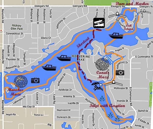
Wolverine Lake, located in Commerce Township, Oakland County, is one of the best lakes for SUP newbies and beginners; at the same time those who grade themselves above the beginners level would still enjoy a ride around it. This is one of the lakes created by connecting several smaller lakes (6, in the case of Wolverine Lake), - usually by a dam built to rise the water level, - and as usually this resulted in a beautiful and whimsical coastline, with unexpected bays, maze of canals, bridges, tunnels and islands - all that makes paddle-boarding fun.
Wolverine Lake Public Access has address 2519-2589 Municipal, Wolverine Lake, MI 48390. You get there by turning on Municipal Dr. from Glendary Rd. - there is a sign, but it's easy to miss, so look for Wolverine Lake Municipal Office building that is better visible - pass by the office, and down the road you'll see an attendant's booth. The access is free, with you R-passport, but on a nice summer day the lot - some dozen of spots - can be full. Two advises for this: first, there is no rule on "spots for cars with trailers only" (don't be bullied by trailer owners, and feel free to take the whole spot - for one or more cars, if you have a company); there are parking lots across the road, in Hickory Glenn Park (a 10 minutes walk).
I advice to start your ride going clock-wise along the shore, especially if you're with a beginner (or you ARE a beginner) - in this way you'll go through the most picturesque and the least busy part of the lake.
You'll quickly be approaching Oak Island - a cute piece of land barely 1000 ft in its longest, but it hosts some two dozens of pretty houses, and even has 2 major driving roads, - Oak Island Dr. and Canal Dr., meeting in its middle. The island is shaped like some cartoon animal with a tail and long ears :), and two bridges connect it to a big land - one adheres to the "tail" and another one the longer "ear". Turn right immediately after the first bridge and explore a little bay; try not to miss an entrance to yet another bay, hiding in the far right corner. Returning from there you can cross to the dam and read the history marker next to it. Follow the shoreline on either side and you'll come to the "ear" bridge. This one is much smaller, perhaps you'd need to kneel to go under it. You'll exit into a very beautiful narrow path between the island and the main land. Keep going along the shore on either side(I prefer to stick to the island's shore, on the right), and in some 20 minutes you should see the entrance to the canals maze. It is located directly opposite from the boat launch (and you can easily detect the boat launch by the orange weed-clearing machine always sitting next to it - you can even see it on the aerial map).
The canal maze of Wolverine Lake is something else... You can easily get lost in it because of all those marshes making a puzzle of unpredictable islands. My advice: stick all the time to the shore on your left. You'll reach to a dead-end (which is one of the most beautiful secluded places on this lake), - turn around and keep same strategy. At times you might think that the canal ends, but you'll always see it's going on around another corner. Eventually you'll reach to a lengthy straight path, and in its end - all of a sudden - you'll see a tunnel (under Shankin Rd.) that takes you back to the open water. If you're with a beginner, turn to the right, and as soon as you exit from the inlet to the main lake you'll see the orange machine indicating the boat launch (on the right, across the lake). By this moment your trip is probably 2 h. long which is usually enough for a beginner. However, if you don't have to wrap your ride up just yet, turn to the left and basically keep moving clock-wise along the shore all the way to the inlet's end, then back from it. If you take a close look at the aerial map of this inlet you'll see it's being spotted with white dots looking like some spikes on the water's surface. These are outlets of the water aeration system. They only built it in this part of the lake (and I haven't seen them on too many other lakes). Unprepared observers often took them for underwater creeks that stream from the lake's bottom :)
Finally (after you turned left on the exit from this inlet) you can go all the way to the far end of the main lake where marshes make another little archipelago to get yourself lost, if you want to (well, not really). And then back to the orange spot - and you made it around the whole lake in, perhaps, not more than 3 hours. I marked on my little map the best, IMO, spots to take a break, and where - during several different rides - we took pictures. The best time to do this ride - mid-October, when the boater activity drops to 0, and the fall foliage is gorgeous, and unlike some other lakes, there are no spots where the water level needs to be high to pass.
Trip Details
-
Trip Dates:
8/19/2018
-
Trip Duration:
Day Trip
-
Sport/Activity:
Stand Up Paddling
-
Skill Level:
Beginner, Intermediate
-
Water Type:
Flat/Sheltered Water
- Number of Portages: 1