
Watauga River in Tennessee
Trip Overview
My wife and I paddled the length of the Watauga River from Wilbur Dam to Boone Lake in our two 14' Georgian Bay touring kayaks. The 19.4 mile trip took us just under 8 hours with light paddling and a couple breaks. We had never done any whitewater kayaking in these kayaks, but we managed to complete the trip without either of us ending up in the water.
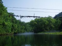
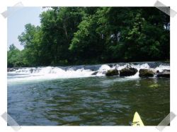
We left the put-in at 9:00 with a heavy mist still on the water. The entire river is absolutely beautiful. There was an abundance of wildlife on the river. We saw cows, horses, deer, many species of bird including many blue heron, snapping turtle, otter, mink, and the ever elusive fishermen. The surroundings are amazing with many cliffs and unusual rock formations including a ledge waterfall.
The river was a great mix of rapids and fast current with some slow spots that would be perfect for a swimming break. I would classify the rapids as mostly II with one or two III- including the aforementioned 3' ledge fall. The rapids are spread throughout the trip with the most exciting being at Sycamore Shoals park.
This trip could easily be a weekend trip as there are many campsites along the river and more than enough to fill several days of paddling.
Accommodations:
There are cabins on the river just below the dam as well as many campgrounds along the length of the river. The nicest of these seemed to be River Ridge Campground.
Fees:
There is no fee to put in below the dam as it is TVA land. There are also a number of free take out sites at the Boone Lake end of the river. Of course, fishing permit is required to catch any of the many trout in the river.
Directions:
From Elizabethton, TN, turn onto Siam Rd. and follow for about 3 miles. Bear left onto Horseshoe Dam Rd., then turn right at intersection onto Wilbur Dam Rd. Wilbur Dam Rd. will take you up to the dam, with the river access road running down to the left before the dam.
Resources:
We used a custom waterproof topo map from www.digital-topo-maps.com a wonderful map creation website.
Trip Details
- Sport/Activity: Kayaking
- Skill Level: Intermediate
- Water Type: River/Creek (Up to Class II)