
Upper Mullica River in New Jersey
Trip Overview
A brief update on this stretch of river (last report was from Sept. 2001).
This stretch is actually 4 miles from Jackson Rd to Goshen Pond. Water level was above average for the Mullica and running swiftly on my trip. There is a "gauge" on the north side of the bridge on Rte 534 (Jackson Rd.) but you'll need to get down to the water to read it and from the water I could see no access to do so. It read 3.10 which, for future reference, will give you a relative value.
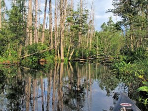
There are 5 downed trees that will require getting out to get over. All are large trunks which will support you should you choose although you can get up on the banks and pull your boat around but none offer low banks, exits from a kayak will challenge novices.
I disagree that this stretch is better for kayaks, the opposite is in fact true. I have used both and find my canoe (solo 12') far easier due to the number of times I needed to get out onto downed trees or the bank. While there are many sawed tree limbs and trunks it is apparent that none are recent and there are many new obstacles that will challenge paddlers. On 3 occasions I had to lie flat on the bottom of my boat to get under trees another inch of water and there would have been 8 get outs.
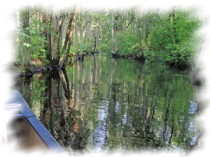
 This stretch is narrower than described. Average 10-15 feet with some stretches 5-7' wide. With the overgrowth from bushes and tree limbs that remain untrimmed there are many long stretches that call for a canoe paddle as kayak paddles will get snagged (I use a kayak paddle for my solo canoe). You will not be able to avoid the branches, there just isn't the room.
In two locations someone has strung steel cable across the river. The first is a short distance from the start and are 2 cables, the lower was about 2-3 feet overhead and would only be a problem in flood level. These cables have no flags but don't need them because of their height. The next (about a mile further down) is a single cable at about 2 feet above the river (yesterday) but regardless of level will always be a problem. There were 2 red flags tied to the cable, midstream, there is enough slack to lift the cable over my head. From the scar of the cable on the trees I would guess that these cables have been there quite some time.
Unlike any other 4 mile stretch of the Mullica the geography and vegetation are consistent. For breaks you have the bridge about 1/2 way down, one of only 2 places to have easy and wide gradual sloped banks to pull up on.
Overall this stretch requires good skills. Not for beginners or those who don't want to work their way down a river. Bring a saw and clippers, I forgot mine and paid a price. I look like I lost a fight with my grandmother's cat!
Accommodations:
None nearby at top.
At 206 go a mile south to "Nina's" for some good food.
Hammonton is 8 miles south on 206.
Fees:
No
Directions:
From Philadelphia, cross the Ben Franklin Bridge on to Route 30. Head for Route 70 east to the Marlton Circle. Then take Route 73 south to Berlin. One mile after the Berlin Circle take a right jug-handle to head east on Route 534. Proceed on 534 through Atco and about one mile past the Atco Raceway stop at the Jackson Road Bridge (no sign coming into Burlington County, but there is a Welcome to Camden County/Home of the Battleship NJ sign coming the other way). Turn right on to sand road, then another immediate right on to second sand road. Carry kayaks fifty yards through brush to river.
Trip Details
- Trip Duration: Day Trip
- Sport/Activity: Canoeing
- Skill Level: Intermediate
- Water Type: River/Creek (Up to Class II)