
Suwannee River & misc. tributaries in Florida
Trip Overview

Stephen Foster may never have gone down the Suwannee River, but after a couple trips with my son, Jeff, and his girlfriend, Andie, I discovered its attractions. Among them were cheap (if $98 for riverside accommodations for 4-6 people is what you consider cheap) accommodations at the junction of the the Suwannee and the Withlacoochee. This put us at one end of three good paddles and within 30 miles of another 4 good sections on the Withlacoochee and Alapaha. I invited some friends and for multiple days of paddling on these and nearby rivers and the adventure was under way.
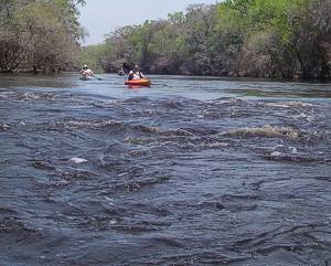
On day 1 (Good Friday, March 21, 2008, also Purim and Full Moon), Omer and I met at the US 41 bridge in White Spings, FL about 40 miles upstream from our cabin. I hadn't realized that I had reserved Easter week. It turned out, I had Good Friday off. Omer, being retired, is pretty much always up for a paddle. We met about 9 AM after I had checked out the Cone Bridge Road access and found the road flooded about a mile from the put-in. (The White Springs gauge was at about 67.5, just below what American whitewater.com considers the Big Shoals to be washed out at.) We put in at the access just above Big Shoals. Arriving at the shoals, we walked the portage trail to scout. The rapids looked a whole lot scarier from above than they did from the water. We ran them anyway, getting slightly wet as our rec kayaks bit through the 2 foot standing waves. No rocks were visible, definitely not a class III.
We proceeded back to the car we left at 41 exploring side runs as we went. No clear springs were visible at this level, although we could proceed upstream on a number of the runs a fair way. At Falling Creek, the footbridge for the Suwannee Trail was just barely under water. There was much lovely spring greenery, something we North Carolinians are starved for this time of year.
On arriving at White Springs, the GPS only read 8 miles and Omer is seeking to accomplish 1000 miles by year's end, so we checked the map and found the next viable take out was Spirit of Suwannee Music Park, about 22 miles downstream. After a quick shuttle we headed on.
The current was steady and high, affording a rapid pace but limited viewing of the famous springs along the way. The Sulfur Springs house, which gave White Springs its name, was visible but the springs underneath was flooded by deep brown, tannin stained water. About 12 miles into this section we encountered a partially flooded wood ramp leading up from the river to Wood's Ferry River Camp. This campsite has hot showers, picnic tables, grills, and screened-in camping shelters. It is one of several campgrounds along the river, which is free and available to only to hikers or paddlers. There was a campground host who met us at the dock and gave me a map of the river. My son has used one of these campsites and says that the host there brought them urns of hot coffee in the morning.
Shortly before reaching Spirit of Suwannee, we stopped at Suwannee Springs on river left. This is described by some as looking like a castle in appearance. In today's high water, only about 4 feet of the stone walls was visible. We paddled though a small opening which is usually pictured as being over the heads of those standing on the shore. Of course, the clear spring was entirely overwhelmed by the dark water coming downriver.
After reaching Spirit, we camped the night at Gibson Park at highway 249, where we planned to meet the others on Saturday. This is a county park with hot showers and a ramp. It costs only $5 to camp. In the morning, we drove back to Spirit for an early launch and a fifteen-mile paddle down to Gibson.
On this section, we passed the Florida Sheriff's Boy's Ranch which has a ramp on river left. We also pulled into a small inlet on river right thinking it may be a spring. I noticed some rest rooms up above and we found that this was the Holton Creek River Camp, another free state run campground. There were some Georgia Tech students camped there who were taking a three-day canoe trip after several days of trail building over spring break.
Just above the 249 bridge, we turned into a wide stream with a healthy flow coming out into the Suwannee. I learned from a fisherman that this was the Alapaha Boil or Rise, one of the points where some of the water from the Alapaha River rises out of a subterranean route after having descended into a sink upstream. This has the appearance of a small sink with one side open and leading out to the river, much like clear water springs. The water coming out is dark, however. The above ground portion of the Alapaha enters the Suwannee, just downstream of Gibson Park.
After retrieving Omer's van from Spirit and dropping it off at the Suwannee River State Park by our reserved Cabin, we met Mary Martha at Gibson. She was the only other member of the group who ended up accepting our invitation to arrive at the cabin by water. We proceeded on down the Suwannee with a short side trip up the Alapaha to assess its current (fast) and navigability (broad). The Suwannee, while dropping, remained high and fast. I had done this section with Jeff and Andie at lower water and had discovered a cave with a spring flowing out which led from a series of sinkholes. There was no sign of the cave above water at this point. Most of the landings and beaches, which I had seen before, were gone as well.
We arrived at the ramp around four and carried our boats up to the cabin. The five cabins at this park are nearer the ramp than are the campgrounds. We found that they are even nearer to Lime Sink Run, which at high water provides more convenient water access to the cabins. Each cabin has two bedrooms, one with a double bed and the other twins. There are also two convertible couches in the living room. They have heating, air-conditioning, full linens, kitchens with all china and utensils, and even dishwashers. Their wrap around screen porches are fully furnished as well with rockers, swings, and picnic tables. We had two for most of the stay other than the first and last nights when there were only six of us.
We were joined Saturday night by Jim, Mia and Mia's brother, Butch. Frank and Katie had a wedding to attend on Saturday and so did not make it until Sunday night. Sunday, we met at Blue Springs State Park to do the final section of the Withlacoochee. This was marked as closed indefinitely due to flooding but we found a dirt road on the north side of highway 6 across from the park which led down to a steep put in spot underneath the bridge on river right. We were able to enter Blue Springs from the river and found it to be putting out enough water to be clear and blue at this level (10.2 feet at gage near Pinetta). Several springs further down were washed out however. Some could be entered in the high water that I had not been able to go into in low water. One was apparently privately owned, being bisected by an ornate bridge with stairs descending to water level (or below it at today's level.) All shoals were washed out as well.
 I did find one narrow rocky entrance further down on river left which had a clear flow coming from a rock lined sink which just barely afforded me enough room to rotate my 12' boat and exit though an entrance about 30" wide. At one point we noted a flock of vultures and discovered that they were feeding on a 2-3 foot long alligator snapper, the biggest any of our party had seen.
On arriving at the Suwannee, we had a difficult battle upstream to Lime Sink Run but the run itself was quiet and beautiful. We maneuvered around treefall to a muddy but manageable takeout near the cabin.
Monday, we launched downriver toward Dowling Park. The shoals just below the park are said to be the second biggest on the river next to Big Shoals, but at this level (13.0 at Ellaville gauge), there was little if any evidence of them. The current was fast, pushing everyone along. We reached Anderson Springs, about 4 miles downstream within an hour and had lunch there. The springs, on river left, were entirely washed out. This is not marked as a put in for canoes but it is accessible by both cars and boats so it would make a good put in for those wishing to shorten this section. There is also a 6-mile mountain bike trail here, mostly single track, which I would come to make use of later in our stay. The vehicle entrance is just below I-10 on River Road, which turns off Hwy 90 between the park entrance and the river.
Later in the trip, some of us explored a broad opening on river right. This turned out to be a flooded rock quarry complete with crane (mechanical not bird). Whether abandoned, or temporarily out of use due to high water wasn't clear. River left after that point became developed by Advent Christian Village with multistory hotels or apartments overlooking the river. There was one attractive looking sandbar in that area, not clearly claimed by the development. Dowling Park itself has a ramp and lots of shady parking.
After this trip, there was a consensus not to do the Suwannee any further downstream than this. The river was getting gradually broader and the main attraction, the springs, were likely to be washed out by tannin stained water if visible at all. We chose instead to seek smaller, narrower streams.
On Tuesday, I had dinner plans with Jeff in Gainesville, so we opted for Ichatucknee, which was on the way there. This spring-fed tributary of the Santa Fe begins within a state park which charges for parking and paddling but the cost is worth it, especially this time of year. From May through September, this stream is mobbed by tubers and rafters, up to the legal maximum of 700 per day. During the winter months, the flora and fauna re-assert themselves and ranger enforced anti-disposable container laws make for a very pristine natural environment. Large schools of fish inhabit various aquatic weeds, which are easily viewed through the crystal waters. This also attracts such fisher folk as egrets, heron, and a bald eagle who put on an air show for us before alighting on his roost for pictures. During other visits, I have also seen otter, beaver, and even manatee in the clear waters of this park.
The park has a put-in at the north entrance, then three lower docks which serve as tram stops for tubers during the summer. Today there were no tubers and we saw only one other paddler. Below the park, the Ichatucknee is heavily developed with multiple docks extending hundreds of yards into the shallow river. The area is a well-shaded swamp however and nature has a way of reclaiming its own from the weekend human residents. At one point, we encountered four otters lounging on the steps of one dock looking like family pets.
The brown waters of the Santa Fe encroached well into the Ichatucknee, darkening its clear water well before the junction of the two streams. We ate lunch on an oak shaded sandbar across from the Ichy's mouth before heading down to the Sandy Point Ramp just below the 129/49 bridge on river right.
Wednesday found us doing a two section, three party trip on the Alapaha. The description of one guidebook of this river as "potentially the most dangerous river in Florida" gave us some pause, but water levels were dropping so we were hopeful. Frank and Katie didn't want to do more than 5 miles so MM, Omer and I joined them for the section from Jennings Bluff Conservation Area down to 41 bridge intending then to go another 11 miles down to the Suwannee and Gibson Park. Jim, Mia, and Butch elected to begin with the 11 mile stretch, so after some creative shuttling and some trips down a very, very long, rough, and dusty dirt road to Jennings Bluff, we had a leisurely 5 mile float followed by 11 miles of our usual pace.
This river has very little visible development. Almost no structures were seen. The high banks were mostly lined by oaks and palmetto. Some of the gnarled live oak trunks looked to be hundreds of years old and incredibly huge. We stopped for a few pictures and resisted urges to climb. This is a really beautiful section of river, especially above 41. Nearing the 751 bridge, I got a call from Jim that his party had encountered a tree across the river which required a portage. On getting there, however, I found a way under using the old Viking burial technique and we continued on to the Suwannee.
There is reportedly a spot where some of the water drops into a sink along this stretch and we saw one stream, which may have been it with water flowing away from the Alapaha but for understandable reasons, did not investigate further. There is also supposed to be a rise below 41 but I think the high water (67.5 at Jennings) effectively masked that today. Again, the upstream portion of the trip, about a quarter mile against the swollen Suwannee was clearly the toughest part.
 On Thursday, Jim and company decided to show Frank and Katie the Ichatucknee. MM, Omer, and I did the next section up of the Withlacoochee from that we had done Sunday but took out at the River Park Ramp located behind the Deer Park Spring Water plant about 1.5 miles below SR 6. We put in at 150 and found the current relatively slow at first. We found that this was due to something new arising out of the dropping waters (Pinetta gauge now at 9.5), shoals. These have a way of backing up water like beaver dams do. Most of the rapids were Class I or less but these provided a thrill for MM, who, until now, had blissfully avoided whitewater. I gave her easy to follow instructions, "Just watch Omer and me, and, if we die, don't go that way". This must have paid off because we all survived the day, having as it did, about 5 or 6 such opportunities.
It was a great day weatherwise with temps in the 70's. There was also Hardee Spring on river left which, although running clear, had too many skeeters for a lunch stop. We did find a good sandbar for lunch. I also found a Swiss cheese shaped limestone island on which to practice my bouldering skills. Blue Springs Park was again open and full of people. Only one baby was brave, or foolish, enough to swim in the spring while we were there however.
At the take-out, Omer's van wouldn't start. Fortunately some electric company guys were there to give him a jump. Unfortunately, he continued to have trouble and it needed to go to the dealership that night where it remains as of this writing awaiting a new engine.
Jim, Mia, and Butch left on Friday to visit relatives and we invited Frank and Katie for the last piece of the Withlacoochee in Florida that we hadn't done. Omer's son, Gary, had also arrived the night before so he came along as well using Jim's spare kayak. This section's put-in is on the GA side of the bridge. Hwy 31 on the left side going into Georgia. The road goes under the bridge to a ramp on river left on the downstream side. There was a clear spring run forming a little waterfall on river left at the first bend.
We found a great sandbar for lunch with exceptional views both up and downstream. Again, development was minimal. Banks were high with saw palmetto and live oak. No impediments were encountered at this level other than a few shoals, the last being the most exciting but still no more than a Class I. The take-out is a re-enforced slope at the end of gradual steps, designed for canoes more than powerboats.
Saturday found Omer, Gary, and I hitting the Big Shoals section again on the way home. The water was about 5 feet lower making them somewhat more technical and a lot frothier. As we played around in the eddies, I felt like I was taking a bubble bath at times. Little Shoals was still not evident at this level. MM helped out with the shuttle and remained to take one of the kayaks back to NC.
Great company, great paddling, and great weather made for an incredible week. Even the Easter Week traffic of snowbirds headed north, a flat tire, and torrential rain on the way home could not sour a great vacation.
I highly recommend those cabins at Suwannee River Park. The staff there could not have been more gracious and helpful.
Outfitting:
canoes and kayaks
Resources:
"Florida's Fabulous Canoe and Kayak Trail Guide"
Trip Details
- Trip Duration: Extended Trip
- Sport/Activity: Kayaking, Canoeing
- Skill Level: Intermediate
- Water Type: River/Creek (Up to Class II)