
St. John River in Maine
Trip Overview
Our Journey on the Mighty St John
. . . . . . . . . . . . . . .
The Voyagers
Ron Paradis and Larry Dreher...........XLTripper
Hans Brandes and Bruce Brandes.........Tripper
Bob Foster and Mike Sands..............XLTripper
Ted Leavitt and Dave Yarborough........169 Discovery
Costs per Person
12.00 per night/4 nights/road&campsite fees.....48.00
100.00 per canoe shuttle fee....................50.00
Allagash Campsite Fee............................4.00
Food Bill.......................................37.00
Gas...............................................TBD
Saturday After months of planning, the trip started with the drive up to St Francis in rain. Hans and Bruce in the Yukon; and Ron, Larry, & Mike in the Expedition started in Topsham at 7am collecting Bob and Ted at the Civic Center exit in Augusta. We met Dave at Dysarts for a late breakfast. Then on to Houlton and up Route 1 for a mid-afternoon dinner in St Agatha at Lakeview Restaurant. The St Agatha homes were well kept and all had freshly mowed lawns with no tasteless lawn ornaments or recycling in the yard, a lovely community. We left Ron's trailer at Gorman Chamberlain's in St Francis, and drove up to Dickey to scout the water level of Big Rapids near the end of the trip. From what we could see, the water looked adequate despite a report we got in Fort Kent from another group that had decided to switch to the Allagash. Water levels had forced us to switch a couple years ago, we had our hearts set on the St John this year. We were relieved to get the thumbs up from Gorman. He explained that his measure was water flowing around the shore side of Cross Rock.
Sunday Early morning fog turned into sun on the drive down to Baker Lake. We left at 7am with Gorman's van and driver pulling Ron's trailer. During the drive, we saw 5 moose, 2 deer, 1 bear and 2 red-tail hawks. The bear was close enough to see his eyes, but unfortunately did not stick around long enough for a photo. We arrived at the outlet of Baker Lake at 11:45 and shoved off with loaded canoes shortly after high noon. Class I rapids began immediately. The river is narrow here with tree lined banks. Our planned campsite was Flaws Bogan. It was already taken by the Nature Conservancy group Larry Totten was guiding so we pushed on another 5 miles for a total of 14 to Morrison Depot getting in at 4:30pm. (Larry Totten is a retired engineer from BIW and now a professional Maine Guide) The site turned out to be wooded and pleasant with a table and privy. Ron and Larry baked bread, and heated chili. We were hungry.
Monday During our breakfast of oatmeal, eggs and english muffins, Father St John (Hans) of the 7-Day Adventurers began his morning sermons. They typically began with a moment of silence for those entering the "W" place, and then continued with a brief sermon and message for the day. This day with Larry as a prop, Father St John presented a picture of one of those driven engineers before 7am with his cell phone and palm pilot already in operation and juggling a coffee as he enters the building. He also sported a paunch due to the lack of physical activity. The message was setting one's priorities. We were loaded and on the river at 8:30 under mostly sunny skies with some clouds. The river gradually widened as each branch and stream emptied in. Dave pointed out a dead elm with 5 holes now being used as a bird apartment house. We stopped for lunch at Knowles Brook campsite. There was a track from a Lombard imbedded in the ground near the picnic table, evidence of the logging operation after the turn of the century. We arrived at Burntland, our campsite for the night at 3:30pm. There were many poplar trees and 2 tables. Today's distance was 24 miles bringing the total to 38 miles. Dinner was beef stew with carrots, onion, and potato; fresh baked bread; with a cherry/blueberry cobbler for dessert. Those dutch ovens are great, the food can be prepared so all can eat at the same time. Ron and Larry did most of the cooking, while the rest of us shared the duties of purifying water, washing dishes, putting up the tarp, and replenishing our fluid levels.
Tuesday We awoke to a frost and just before oatmeal, pancakes, and bacon, 2 moose made a crossing just up-river. By 8:15am, the canoes were loaded and on the river. Ron had found powdered Gatorade and we each mixed a couple quarts to take with us. It was mostly sunny and stayed that way for the remainder of the week. The water level required us to sharpen our river reading skills, but there was always a channel for those watchful enough to find it. We observed the direction of flow and listened for the tinkling of shallow riffles to avoid the hard water. We stopped at the 9-Mile Bridge location. The ice removed this historic steel bridge in 1972 and carried it downstream. There is still a cable and cable car crossing the river; we got out for a stretch and looked it over. From here it is 9 miles to Seven Islands. Today, we saw a bald eagle watching us pass from his perch in another dead elm. Shortly after, there was a live fully leafed elm, not many live elms left in the state. Dutch elm disease destroyed many majestic elms in the state, I will always remember how the great tall elms lined Court Street in Houlton forming an arch as they leafed out each year. We also saw kingfishers and Canadian geese. We arrived at Priestly campsite at 2:30 adding 22 miles for the day increasing our total to 60. Our DeLorme St John/Allagash map showed the bridge in the old location and needs updating. The campsite was grassy and open. Bob cut 4 poplar supports to hold up the corners of the tarp. We rested before starting supper of baked chicken, and vegetables with a pineapple upside down corn bread dessert. We used single burner stoves this trip and decided they were a success and easier to pack. This was also the first trip for the barrels providing great storage for the match light charcoal. The airtight lids with clamp rings make them ideal floating storage.
Wednesday Another hearty breakfast of oatmeal, bacon, eggs, and english muffins, and we were on the river at 8:30am. Father St John's sermon was about acronyms and abbreviations this morning. ECP (engineering change proposal) is defined as Excellent Canoe Paddling, and FMR (field modification request) as Finding More Rapids. It was a timely sermon because rapids were the order of the day. Priestly Rapids was a long class I-II rip. The water level now seemed adequate most everywhere and the long rapid was great. During a couple more short rapids we spotted another bald eagle, and soon entered Basford Rips, a second long rapid. Still before lunch, was Big Black Rapids, a 1-mile class II-III. Gorman's advice was river middle. Dave and Ted took the lead into our most serious challenge yet. The Big Black path required navigation skills to avoid the rocks plus back paddling to slow our tempo to keep the class III waves from splashing into the loaded canoes. We were all up to the task. Our lunch stop was at the confluence of Big Black River and the St John. We sat on the porch and around back of the immigration cabin taking advantage of the shade. Our campsite was at Longs Rapids at mile 83, we arrived at 3:30pm adding 23 miles this day. There was a brook on the upstream side of the site with a good supply of clear water. The water in the St John has tannin making it look like tea, which also clogs water filters quickly. Dave's PUR Pioneer could be set up to gravity siphon water from Larry's gray rubber bucket into our water containers. The simple inexpensive model sometimes outperforms the more expensive higher capacity models. There were many anthills at this site, but the ants mostly kept to themselves, with the exception of Bob's basket. There was a rabbit in residence here coming out often to graze on the grass on the access path. The menu for this evening was charcoal steak, fresh baked bread, potatoes and onion wrapped in foil, carrots, and 3-bean salad with popcorn later. Ron got me a salmon steak to accommodate my diet restrictions. He made an effort to prepare healthier meals this trip. Individuals are each responsible for lunches and I also brought along soymilk for my decaf and oatmeal.
Thursday From the high bank at the edge of the campsite, I watched the sunrise while having coffee. The river was even broader now with 50-foot wide rock beaches before transitioning into a tree line. We theorized that the ice freezes deeply into the river and goes out with vengeance clearing a large swath. Bob was also up early and discovered a single campsite down the rabbit path. It had a new knotty pine privy. We were loaded and out on the river at 8:15, it was again sunny, but the wind out of the northeast added another degree of difficulty. We kept hugging the shoreline to minimize the effect but the river was wider and always seemed as if we were going into a wind tunnel. Just another way that the Mighty St John presented itself. We stopped mid morning for a break and found a large rock with many small rocks embedded, a conglomerate. The freezing action of ice and rock had made the surface look as if someone took a grinder to it. Dave and I also picked up a couple green rocks for Dad's grave. We had noticed the green, perhaps from oxidizing copper deposits prevalent in rocks along the way. The rock Dave suggested was roughly 5 inches in diameter with a window the size of a dime exposing an inner center of quartz. We lunched at Poplar Falls campsite deciding it would be a buggy site because of the damp area leading into it.
Then it was on to Big Rapids, class II-III winding downhill dropping 40 feet in 2 miles. This time Ron and Larry took the lead with Dave and I at sweep. It was primarily class II and wide with many rocks. At one point we rounded a bend and it looked as if we were on top of the headwall at Sugarloaf. We had to check if we were on skis or in canoes. It was an intimidating sight. Ron chose a route generally down the left side and we back paddled to slow our progress. As we got closer to the end, Dave and I ventured out into the middle for bigger waves. Near the bottom we attempted a path between a large rock and ledge. The left to right wind pushed us too far left and we went down over the ledge submerging the bow in the foamy aerated water. With the extra water, we eased our canoe to the end of the rapids and caught a submerged rock while eddying into shore. Bob said the Old Town decal at the top of the gunwale was submerged. Tipping at that point would have cost us any style points we might have gained. All canoes made it safely and there was a rocky beach down the left side had there been any not wishing to attempt the Mighty Big Rapids.
We checked out the Walker Brook campsite. There was a long hike with a steep bank so we elected to push on to a private site in Allagash Village. After crossing under the Dickey Bridge, we pulled over to the beer store and drifted the last 2 miles replenishing fluids and soaking up the sun. Hans and Bruce had gone way down ahead, but we shared what was left. The campsite was on the right just after the mouth of the Allagagash River. It was 4pm, we had gone 23 miles bringing our total to 106, and the mowed grassy site went right to the rivers edge with no hike up the bank. The charge was 4.00 per person. Ron had saved chicken pot pie for the last dinner, I think we all had seconds or thirds.
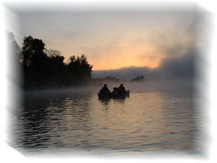
Friday We got up at 4am, packed up and started the final 4 miles at 4:30 for a sunrise paddle. There was ice on our drybags this morning and gloves were needed. The cold air caused an eerie fog on the water. In addition, the rapids were higher and more frequent than expected causing us to use the force for navigation. When the sun pierced the fog, the reflection required even more reliance on the force. Cross Rock had very little if any water flowing on the shore side now, we made our trip just in time. We reached Gorman's campsite at 5:45 and were loaded and headed toward the Fort Kent McDonalds at 6:15am, but not before Father St John's final sermon of Partnerships and Friendships. Over the 110 miles, we improved our river reading and paddling skills as well as strengthened our friendships adding a couple new members to the group. During a pit stop at the Irving in Houlton, Dave and I visited Dad's grave placing the rocks from the St John. We believe Dad would have had the same voyager spirit burning so strongly within us.
St John Trip Reflections - June 16, 2001
Perhaps a topic for Father St John could be to have us think about how we make the journey. An affliction that is present in all of us to some degree is rushing to the destination. We set many goals in life, as we reach one another takes its place. So our families can have it all, our schedules are set to suit. The result is focusing too much on the destination. The problem with keeping our eyes on the destination, is that we miss the beauty that lies along the way.
Our trip on the St John was certainly an ambitious goal of 110 miles spread over 6 days. To make the distance, perhaps too much focus went into pushing through that 23 or 24 miles each day to the next campsite. Tunnel vision usually gets us to the goal faster, but leaves us impervious to the splendor around us. Are we paddling to reach some destination, or are we trying to become it touch with the watershed, to appreciate the transformations along its path? Sure we want to reach the end of the journey to notch another trip in our tally of life experiences, but the significance of the trip is to treasure the struggle. How can there be euphoria at the end without joy in the journey?
Although the drive to succeed helps us grow, but we cannot truly appreciate the goal of reaching the end without cherishing the whole journey. When climbing a mountain, the summit is the smallest feature. Without the bottom to climb, there could be no top. The true beauty is rarely found in the destination, but in the flowers that are overlooked and trampled along the way.
Outfitting:
Gorman Chamberlain, St Francis, ME for shuttle to Baker Lake, our start point.Directions:
Interstate 95 to Houlton, Route 1 to Caribou, Me161 to Fort Kent and on to St Francis.Resources:
DeLormes Allagash and St John River Map and Guide.Trip Details
- Trip Duration: Extended Trip
- Skill Level: Advanced
- Water Type: River/Creek (Up to Class II)