
St. John River in Maine
Trip Overview
 The St. John River IV
 Saturday, May 21, 2005.
With months of planning behind us, the St. John River IV Adventurers are:
Ron, age 44;
Jeff, age 41;
Mike, age 42;
John, age 50;
We all gathered at Rons house in Biddeford, Maine. We strapped down the canoes and packed all the gear into Jeffs four door GMC pickup and headed north 192 miles to Rockwood, Maine. From here life as you know it comes to an end as we turned onto the 20 Mile gatehouse road. At the gatehouse we would each have to register our trip plan that cost us $11 dollars each per day for our 5 day adventure.
We will travel on all dirt roads with many names (20 Mile, Soldier, Pittston Farm, Golden, 490, Baker Lake and St. Aurelie Roads) as it zigzags through a working forest. For the next 110 mile on this rainy day, you can forget being a puddle-jumper with your truck to the Northern end of Baker Lake (Location = N 4617.250 x W 6955.450).
We setup camp at Baker Lake (T7 R17 WELS) in a light rain and a brisk wind. Mike and I (John) would team up in his nearly new Old Town Allagash Canoe and Ron in Jeffs twenty year old Mohawk Canoe.
This St. John River trip should treat us to strong, nearly continuous current with many class I-II rapids and two class III rapids. Lets hope we planned ahead properly because there are no supplies or services available along the river.
The following terms are frequently used in this story to rate the river:
Deadwater: Absent of any visible current; like a pond.
Flatwater: Visible current with swirls and eddies around rocks and along the shoreline.
Quickwater: Current flows nearly straight ahead; water flows over rocks and the sound of flowing water can be heard as eddies form a "V" behind them. Current flows around 4 MPH.
Riffles: A section of Shallow River in which small waves are noticeable, usually over a gravel or sand bottom.
Rips: Similar to riffles only stronger in nature; maybe whitewater showing over small, head-size rocks, spaced widely apart.
Rapids: Usually where the river seems to fall down in front of the canoe; more obstruction, larger rocks spaced closer together, with a heavier volume of water than rips.
Standing Wave: Large curling wave that stands right up out of the water.
Chute: A channel or gap running through an otherwise obstructed course. Normally a strong volume of water squirting between the obstacle in much the same manner as water being poured quickly from a pail.
River Classification, the International classification System that follows allows the reader to measure the various difficulties encountered on this whitewater river. Remember that experience, sound judgment and precautionary safety measures are very important. This is not a canoe trip for beginners!!
Sunday, May 22, 2005.
We awoke to a stiff north wind and a raw 44 degrees with a light to steady rain. We all put our rain gear on and I was wearing my long-Jons with wool soxs and almost waterproof hiking boots.
We packed our canoes and paddled out onto Baker Lake, we asked Jeff and Ron if our canoe looked balanced with our load and Jeff and Ron told Mike that the stern of the canoe looked as if it was about to go under. Mike was concerned with that until Ron and Jeff admitted to having fun with Mike. With a good laugh we started our 125 mile canoe trip down the St. John River.
Mike headed our gear laden canoes under the Saint Aurelie Road Bridge, we than entered small rips as the Baker Branch of the St. John River zigzagged along (6250 CFS being reported at the Dickey Station). We had good quickwater to get us going with a few class I rapids. The trees along both banks showed the damage of the recent winter ice going out. It was exciting to start down one of Maines greatest whitewater rivers.
We had some early problems with the rock choked river. It got narrow and our canoes had about 800 pounds of personnel and gear in them. This made the canoes have a rather sluggish response in the quickwater. We could see colored markings from other canoe adventurers on several of the rocks in the river as we glided passed them. Jeff and Ron rode up on one of these rocks which they did not see coming, they rode right up on it as they were looking along the shore for moose. They listed to the starboard-side (right) and the river rushed in, half filling their canoe with water. Mike and I thought that they were going over. It was way too early in the trip to capsize. Jeff and Ron both struggled to keep their canoe from flipping over and saved themselves from the very chilly waters of the St. John. While they were both hand bailing water from their canoe, Mike and I came face to face with our own rocky situation and had to back paddle out of the rocks to continue on down river.
We had traveled a couple of miles when Turner Bogan Campsite came into view on the right-side of the river. From Turner Bogan we had deadwater for three miles when we came upon a lovely log cabin shelter at Flaws Bogan along the Foss Brook and even thou it was early we voted to get out of the rain and stay the night in the cabin. There was an old wood stove in the cabin which allowed us to warm up and dry out our rain soaked gear.
Monday, May 23, 2005.
I had set a home-made river gauge in the bank of the river to monitor the river level and it showed that we had an extra inch of water (6500 CFS at Dickey.) and the air temp was still 44 degrees with a steady rain.
It was around 8 A.M. when we pushed off and I (John) floated us down around several curves in flatwater. We would find deadwater with a stiff Northwind blowing in our face which made heading up into the wind a blistering event for five miles. As I paddled into the rain driven wind while wearing my raingear I looked over to the bank of the river and up into the incoming streams for any wildlife. There was an abundance of ducks of many varieties and a few ospreys. We made bird sounds as we paddled along as if we were talking to the ducks. We had a squadron of Woodys (Wood Ducks) glide by that sounded like a jet-fighter roaring overhead. That was really cool.
Paddling deadwater can be monotonous if you focus on the task of getting to your destination. I prefer to look around and ponder some of lifes treasures and before you know it, you pass that point that seemed so far ahead. So with five miles of deadwater ahead, I had plenty of time to ponder if we were going to stop for lunch before the Southwest Branch of the St. John. The Southwest Branch is as wide as the Baker Branch where it enters from the left side of the river, the river again turns to quickwater and widens (doubles) at this point. The Southwest Branch and Sunset Island Campsites are located in this area.
We were now in mostly quickwater with occasional Class I rapids as we paddled four miles, passing Doucie Brook Campsite in mostly flat to dead water. In another four miles of small rips in mostly flatwater, you will see Knowles Brook Campsite and the Northwest Branch of the St. John entering on the west-side (port, left) of the river.
Again another four miles will pass and the rain turned to a drizzle as we entered the top of Ledge Rapids. We had paddled thirty miles today and we were soaked to the bone and with the cool temperature we were ready for hot food and some down-time. So at four in the afternoon, we pulled out at the Ledge Rapids Cabin.
This cabin was not as neat and modern as the Flaws Bogan Cabin. The roof was ok, but the interior was full of critter nests and smelled very musty. We started by sweeping the dust covered floor and picking up the clutter. Then we got the wood stove going and we hung all of our wet gear around the stove to dry them for the next day of paddling.
The rain stopped in the early evening and we enjoyed a sunset as the sun dropped under the clouds to the west, putting a yellow glimmer of gold on the river.
The cabin was small and rustic and I decided to sleep out on the porch. During the night the river rapids serenaded me as the full moon poked its face out of the clouds to say hello. What a great night!!
Tuesday, May 24, 2005
Sunny skies greeted us today as we awoke at 5 A.M. It was warmer this morning at 48 degrees. Again, I had a river gauge and this morning after all the rain from the previous two days, we had five more inches of river (7500 GPS at Dickey).
Today, Mike would be at the helm and he guided us off the shore and we had to quickly paddle to the far right side of the river as we entered the Class II Ledge Rapid on the right (Starboard) side of the river. We took a few small standing waves over the bow. There is a large wall of jagged black ledge hence Ledge Rapids, lining the shore. Those small black waves that land right into your lap are just the thing you need to wake you up in the morning.
After a mile we went under the Moody Bridge. The spring ice going out took one of the massive concrete bridge pillars and laid it face down into the river. The bridge is sagging on one end and has been closed to traffic.
We pulled along the quickwater shore just below the bridge in search of fresh spring water for drinking. There was a group of kayakers camping at Moody Bridge Campsite and they pointed us in the right direction for the spring water.
After filling our water jugs with fresh spring water we pulled back into the quickwater and glided down into the Class I rapids that went on for a mile.
After theses rapids we should of been canoeing deadwater for several mile, but due to the higher volume of water we had flat to quick water.
We passed Red Pine Campsite and two miles down river comes Burntland Campsite and another couple miles of deadwater. This area has a few signs of a major forest fire back in 1935. So, while youre enjoying your campfires at night keep in mind, that only YOU can prevent forest fires
The water drops in Class I-II rapids between stretches of quickwater until Nine Mile Bridge. The bridge was removed by spring ice back in 1972 and only a cable cart with red warning balls now span the river. The Nine Mile Rapids has a good pitch and for the next ten miles there are more Class I-II rapids with several rips to enjoy before coming to Seven Island Campsites.
In about three miles, we came to Priestly Bridge and than Priestly Deadwater, it seemed as if we were paddling uphill. Just stay focused; because life is like a river, it goes where it has too. Not where it wants.
After another blister from paddling uphill and into a very stiff northwind we crested the three miles of Priestly Deadwater. As we entered the waters leading toward Simmons Farm we could see were the river slid off to the right in small branches that flowed downhill. It was tempting to turn down these small branches while the bulk of the water remained on the uphill side in a flat to quick water flow.
We pulled over to Simmons Farm and scouted for a campsite. We had traveled another 28 miles today and I was spent and ready for some downtime.
We setup camp on a knoll that overlooked the north flow of the river. We were all sun and wind burned from the long day on the river and quickly set out to relax and enjoy a hot meal and good company.
After dinner there was a lot of talk about the next days rapids. Big Black and Long Rapids were on the agenda for the next day.
Wednesday, May 25, 2005.
Our homemade water gauge shows more water over night (8100 GPS at Dickey) and it was my (John) turn to paddle the canoes down river. The water drops slowly from Simmons Farm for five miles to Basford Rips Campsite. Basford Rips was a real surprise to all of us. We made this right hand turn and at the bottom of the turn was a rip that crossed the entire river. We had not read anything about Basford Rips being difficult, so we just paddled right into it. We thought that the loud sound of the rushing water was more like a rapid. Jeff and Ron chose the left side and Mike and I chose the right side of the river to enter the rips.
When we emerged from the rapid we were both bailing a significant amount of water out of our canoes. There was a series of rips, followed by a short Class II rapid and at the bottom of the run is a two foot standing wave. It was the standing wave that came over the bow and tried to swamp us. Maybe next time Mrs. Basford.
So far today the usual jibber-jabber was absent as we paddled along. It seems as if everyone was making peace with the thought that one of the toughest rapids was coming up. Now that we had crashed through a somewhat no-name rapid (Basford), we were getting anxious about meeting the BIG BLACK RAPID and it laid ahead in only four miles.
What would Big Black be like if Basford tried to sink us? Should we portage around Big Black? Should we line our canoes down Big Black? Should we turn around and paddle back upriver to the nearest bridge? Mike, who was sitting in front said Take it down the throat of the beast!.
As we rounded a long right turn we could hear Big Black Rapid. We were choking as to how close we should get to the edge of the rapid before pulling over to scout it out. We pulled over in the quickwater and walked the right side of the high ledges scouting out a path. On my return trip I walked the bottom edge of the Big Black to get a water level view of all the obstacles.
Loss of canoe and gear in this remote rapid could cause a great hardship. So, I plotted the safest path I could. What I planned was to run strait down the right side, avoiding the large rocks and diving into the 3 foot standing wave that would be waiting for us half way down the rapid. The bottom half of the half-mile long rapid was filled with large rocks and this would be a Class III ride.
We decided that Mike and I would go first and we would stop half way down and become the safety boat for Ron and Jeff in the event they capsized. This is a good practice, rather than clog up a narrow rapid with two canoes both trying to stay upright. Maybe we could get Fear-Factor to try this as a stunt.
So, with a push of the paddle we were off and into the mouth of the beast. I paddled the route that I had scouted and when Mike offered a different plan I refused the offer. The last thing I wanted to do in ten MPH water was to try to paddle left or right across the strong current. I consider myself an intermediate paddler and could use some advanced whitewater classes
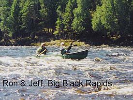
Back to Big Black Rapids, we rode the tongue of the beast right into its throat and slammed through it with only a couple of standing waves breaking over the bow. We quickly paddled over to the right and Mike held the canoe to the shore while I grabbed my camera and ran up river along the ledge to snap the following pictures of Ron and Jeff riding the beast down river.
After snapping a few pictures of Ron and Jeff I ran back to Mike and the canoe and pushed back off shore and into the second half of Big Black Rapids. This half did not have the high black ledge along the shore but it still demanded your attention to safely maneuver around the numerous rocks in this Class II-III rapids.
Ron and Jeff were at the bottom and took pictures of Mike and I working our way through Big Black rapids. Of course now that we had run Big Black and all the anxiety of the day was diminishing, we thought that Big Black was like a school yard bully that talks tough and makes you sweat. But, do not underestimate this bully (Big Black) it is a force to be reckon with and give it a scout before you give a shout (for help). It will make your day.
Below Big Black Rapids is a campsite and if you had the beast eat you up and spit you out, leaving you all wet and gathering your gear, than this is a good place to stop for the night. Big Black Campsite sits on a point were Big Black River comes in. At this point the water is mostly flat to quick water and the river widens with the addition of Big Black River entering the St. John.
In a couple of miles we past Morrell Shed Campsite as we paddled a long stretch of mostly flatwater for four miles to Long Rapids. Long Rapids is mostly Class II rapids and I turned on my tape recorder to record the beautiful sound of white water boiling around the canoe. We had small black chops of standing water all around us a we canoed down the middle of the rapid. It made a perfect whitewater end to my great day of paddling the St. John. We passed the Castonia Farms Campsites and entered the washed out Schoolhouse Rapids, passed Ouellette Farms Campsite. Keep in mind that these farms are long gone and the forest has reclaimed what these brave farmers accomplished a hundred or so years ago. Today they are small grassy areas that allow for good camping sites.
Two sets of small rapids, Note, that now we have canoed Class III rapids, I find small rapids. Keep in mind that a small David took down Goliath with a small rock. This is still no time to lose your canoe and all that equipment.
We had paddled our 30 miles for the day and around 4 P.M. we pulled over to Fox Brook Campsite and again we commenced the task of unloading the canoe and setting up camp. At least it was sunny and we all sported a good sunburn to prove it.
Thursday, May 26, 2005.
Last night an old-timer picking Fiddleheads told us it would be raining this morning. I told the group look at the sky, not a single cloud, I doubt if it will be raining. Well its 7 A.M. the temp is 45 and the river has dropped three inches (6500 from a peak of 8100 GPS from Dickey) and it is raining steadily.
Mike has not been feeling well for most of the trip and today he will ease us off the shore and headed us down river.
Around the next four mile horseshoe bend is Big Rapids. The Old-timer told us good luck with Big Rapids, he added that if we made it through Big Black that we should make it through Big Rapids and to stay to the left of the river. We could pull over to the left and scout the three miles of rapids, but Mike already had his plan of sticking the canoe into the mouth of the beast and riding it right into the throat of the beast. We could portage on the left side of the river. Guess again!!
What is really neat about the Big Rapids is that when you start into it at the top, its like being on top of a high hill and the river bends off to the left and disappears. Keep in mind that at this time the water is just smooth and black moving along at quickwater speed with no rapids as we start dropping 40 feet into a big abyss. The river then straitens and we get to see some of the whitewater rapids that are now turning to the right. These rapids are Class III with all the trimmings, like Rips, Chutes, Drops over large rocks and three to five foot standing waves. We would take a wave over the bow and I would immediately begin to bail it out. I would lean way back onto the packed canoe to try to shift our weight back and keep the bow of the canoe from plunging into the standing waves. Wave after wave, turn after turn to avoid the large rocks as we bobbed down the three mile long rapids. Every now and then we would look back (when we could) to see if Jeff and Ron were still afloat. It seemed like forever that we were in the grip of the beast as it pounded us and slapped us around while spitting water into our face. But, just like a tornado it came to a silent end and we turned our canoe to look back at the greatest challenge of the trip. We bowed our heads in respect to Big Rapids and than Mike and I turned to each other and slapped our canoe paddles in a hi-five motion as we shouted out in a victorious glee.
Mike and Ron were doing the St. John shuffle in their victory dance as we pull up to shore for pictures and celebration. Here on the shore below Long Rapids lay the remnants of this springs ice jam. We walked up to these twenty foot chunks of ice and took pictures to prove that they still existed here on Thursday, May 26th, 2005 in the most northwestern town of Dickey, Maine. Population Not Many.
The greatest challenges were behind us and we had another ten miles of quickwater and small rapids ahead with the Great Allagash Waterway terminating its 90 mile trip into the mighty St. John River.
We ended our trip at Pelletiers Landing, were I exited our canoe and steeped ashore, I dropped to my knees and bent over and kissed sweet Mother earth in the soft mud and looked at the six blisters on my hands after canoeing five days and traveling 125 miles on the mighty St. John River, our awaiting vehicle in the town of St. Francis (N 4710.493 X W 06054.414) signaled the end of this great adventure as the St. John River IV
In closing let me say that in an effort to keep this story short I left out all the great meals, laughs and times that The St. John IV of us enjoyed while camping together as I tried to describe just the river and our paddling experience on the St. John River.
Thank you to my fellow paddlers, Jeff, Ron and Mike for making this trip a REALLY GREAT ADVENTURE. To my Queen Cathy and all my Ancestors for looking over me and keeping me safe on this trip.
Happy trails to you, until we meet again. Happy trails to you, keep smiling until than. Happy trails to you, till we meet again.
The Adventure Boy,
John G. Lambert.
May XXVI in the year of the Lord, MMV.
Trip Details
- Trip Duration: Extended Trip
- Skill Level: Intermediate
- Water Type: River/Creek (Up to Class II)