
Roanoke River in North Carolina
Trip Overview

Roanoke River / Cow Creek
Started in Jamesville, NC.
The weather was questionable with rain anticipated and large thunderclouds were visible in the distance.
The river is wide and slow moving and tracks northeast for about 6 miles where Broad Creek discharges into the river from the west. Due to the relatively long stretch of river between the town and the creek some swell can build if the wind is right and blowing hard, but on the day I paddle it was not a problem.
The paddle along the river is quiet with very few houses or structures along the way. Mile markers are placed to aid in tracking your progress and the entrance to the creek is well marked and easy to find. Once in Broad Creek you will notice the water is relatively clear. This is due to a canal that diverts some flow from the river further upstream.
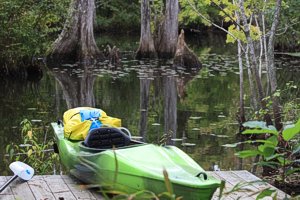 I stayed on a platform on Cow Creek which branches off Broad Creek not far from the Roanoke River. The bass fisherman were active during the day but as evening approached they returned to the ramps and left peace and quiet behind.
I spent several hours inside my tent during the day due to passing rain showers and then as evening came and the sun began to set the showers stopped and I was able to paddle and take photos. I felt privileged to have the creek all to myself.
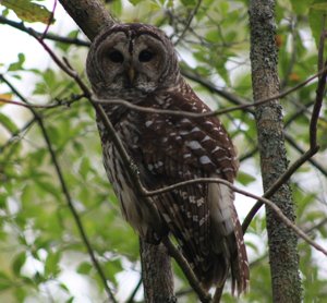
The next day I explored the creeks which took most of the day and then made my way back upstream to Jamesville. At a spot all the way up Broad Creek I stopped for lunch at Cypress Cathedral and not long after arriving I noticed a Barred owl staring at me so I took a photo. The owl soon swooped down to capture some small prey and I watched in amazement. What a way to cap off an already great trip.
Accommodations:
The platform can be reserved online and the facilities are great!
Outfitting:
OT Sport (10ft hybrid with drop down skeg)
Mountain Hardware 1 man tent, dry bags, backpack stove, rain gear, compass, cellphone (not a reliable signal), GPS
Fees:
$20 for one or $10 each for a larger group
Directions:
Hwy 64 East to Jamesville, NC
Access a ramp off Water Street.
Resources:
I had charts but a printed map from the web would have been just as good.
Trip Details
- Trip Duration: 2-3 Day Trip
- Sport/Activity: Canoeing
- Skill Level: Intermediate
- Water Type: River/Creek (Up to Class II)