
Rappahannock River in Virginia
Trip Overview
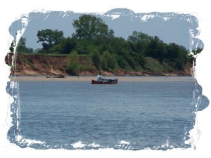
Fones Cliffs on the Tidal Rappahannock River
I left the Carter boat landing paddling downriver, with an outgoing tide made irrelevant by a stiff head wind. The skies were partly cloudy, with a high of 80 degrees expected. The water was only faintly brackish and a bit cooler than the air. The mediocre view from the landing got much better out in the river from where I could see the entire line of Fones cliffs: tall, vertical, and white. Not Dover-white, but a clean look nonetheless. Despite the gorgeous weather and scenery, it was going to be a day where Mother Nature wouldnt allow me to make many choices. Can I wear my big, floppy hat? No, Ill blow it off, she quickly seemed to answer. My late start, plus the strong wind coming straight up the river, meant I wasnt going to cover a lot of ground. So I gave up the notion of a long tour and decided to enjoy some fine-toothed beachcombing.
Where the river is busy nibbling at their toes, the cliffs are sheer. On my visit, enormous oak trees hung over the cliffs edge with half the roots exposed, and large acorns were raining down like hail. There was surprisingly little deadfall on the shores however, suggesting that this river is powerful enough to clean up its mess. The cliffs farthest upriver are presumably no longer undercut since they are reverting to forested slopes.
 The cliffs consist of a sandy dun- to reddish-colored clays on top of a grey-white marl. Marl is a clay containing enough calcium and magnesium carbonate to change its texture to something not so sticky (more permeable). As a gardener, I sprinkle gypsum on our coastal clay soils to achieve a similar effect. A brick of dry marl freshly fallen from the cliff sounds almost like a piece of wood when you knock on it, and will even float for a few seconds. But it can be reduced to crumbs with a little effort. Vertical cracks pierce the marl, possibly as it dried out when water levels dropped millions of years ago. These cracks have been filled by iron minerals, chunks of which litter the beach. But the important cracks are the ones which occur as the outer face of the marl gets wet and swells, splitting car-sized blocks off the cliff face. The cliffs are non-fossiliferous except for a few large concretions containing the odd shell or two, poorly preserved in iron minerals.
The Captain Thomas cruise boat passed by taking a load of sightseers upriver to Leedstown to visit Ingleside Plantation Winery. The river between the cliffs and Paynes Island is quite wide, but the big boat almost hugs the cliff shoreline to give the tourists a better view of the stuffed bald eagles in the trees atop the cliffs. (Just kidding.) It was my own familys ride on the Rappahannock River Cruise a month earlier which had introduced me to the beautiful Fones Cliffs and was the reason I was now standing on a thin shoreline being bashed by the Captains waves. The waves and narrow beaches below the cliffs made me really appreciate my new kayak toy, a foldable 1 lb anchor with 4 flukes. Todays high winds also helped me realize that swimming after a loose kayak is sometimes less of an option and more of a drowning fantasy.
As I paddled along the shore, I was escorted by a trio of turkey vultures. "Am I really going that slow?" was my annoyed thought. But the birds were interested only in the dead fish floating around me in the water, and were conserving energy wheeling in the updrafts along the line of cliffs, waiting for a fish to drift ashore. Large dead fish floating on a river are a normal part of the scenery, but the concentration at this location was unusual. (I dont think evolution missed filling that niche; there just arent many truly giant catfish anymore.) The only thing suspicious was the line of net strung across the river outside the deep channel.
Several times as I stood on beaches, I was astonished by a rolling thunder so powerful I could feel it through my feet. A cats paw touched the river, and bait fish jumped to escape. Clear blue skies suggested not thunder but enormous and distant explosions. This wasnt something I expected in rural Westmoreland County where I had to shoo a brightly colored male box turtle off the road, and where the morning glories were so thick and intensely violet that you could drive into a ditch from the distraction. I later found this part of the Rappahannock River is within 20 miles of several military installations (Fort AP Hill plus others on the Potomac River) which live-fire large weapons. Its astonishing that on the East Coast, where you cant spit without hitting a real estate developer, there are still places one can safely detonate 500 pound bombs.
As I passed the last of the cliffs, the headwind had increased and was producing 2 foot waves, frustrating dinner plans for the only belted kingfisher I saw. An immature bald eagle passed overhead. The tide had turned against me as well, so it was very slow getting to my planned layover at Jones Landing. There I found an immensely strong but short pier which was useless for launching boats, but ideal for transferring heavy bushels of oysters between a boat and a truck. Another half block downriver theres a more generally useful small boat landing.
I couldnt make significant headway further downriver with all the elements against me, so it was time to make the short 0.5 mile open water crossing to Paynes Island. I rigged for an open water crossing, and was glad I did since the waves mysteriously increased to 3 feet in the deep river channel. My route took me nearly parallel to the waves so it was a wobbly trip even with a rudder. I began keeping my eye on the oncoming waves as I would a large, suspicious dog. Fortunately, things calmed down as I approached the opposite shore.
Pushed along the shoreline of Paynes Island by both wind and tide, progress was swift. A home appeared almost abandoned, but someone passing by my backyard might think the same thing. Gulls crowded a pier, facing into the stiff wind, softly chortling to one another. Cormorants perched on the line of nets in the river. From all the nets and crab pots Id seen, the Rappahannock River between Tappahannock and Leedstown is being vacuumed pretty hard. By this time, Fones Cliffs were glowing brightly across the river in the late afternoon sun. The view of the cliffs from the banks of Paynes Island shouldnt be missed provided you can get there safely. My daughters digital camera took a swim earlier, so sorry no pictures from this side of the river. (Never lend a paddler your camera.) An attractive home was now visible atop the cliffs. Perhaps in a few generations the home will join my daughters camera.
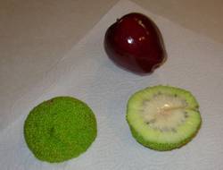 Walking the small, rapidly shrinking beaches, I found an osage orange tree hung with heavy, softball sized yellow-green fruit. If youve never seen one of these girls showing off, its an amazing sight. Being from Iowa where hedge-apples are familiar to little boys as more-fun and less-lethal projectiles, I brought one home so my Virginia family could discover the wonderful citrus-with-pine-overtones smell. Its apparently not an old wives tail that they contain a natural insect repellant: the ant problem in our kitchen disappeared during the two weeks we left the hedge-apple on the counter, and the ants returned within days of throwing it away. Not exactly a well-controlled experiment, but Im convinced!
Farther upriver, the agricultural sandbar called Paynes Island gave way to marshes. The marsh hibiscus flowers had gone to seed, but small, intensely yellow daisy-like flowers brightened the entire shoreline. Two turtles that dove off a log may have been terrapins; Paynes Island is certainly high enough for nesting.
The wind had continued to pick up, and whitecaps were occasionally visible near the opposite shore. A bass boat called it a day and roared back to the small white dot which was the Carter landing. At this part of Paynes Island, the southeast wind was shooting straight down a 6 mile fetch. As long as I crossed now, my trip would be more downriver than cross-river, so the wind, waves, and tide would speed my journey. When I reached the deep channel, I checked over my shoulder, saw the wind-whipped 3 foot swells, and decided not to look again. It wasnt necessary anyway, because I could hear the baddest dogs growling as they collapsed behind me. I made a mental note to pull the scupper stoppers from the tank well and throw them away. An extra 50 lbs of water slopping around in the back of my SOT kayak would have spoiled the end of a great day.
Coming into the wave-bashed landing was a real whitewater experience. If I had overshot, I would have had to walk back along the shore because I could not possibly have paddled against the combined force of the wind, waves, and tide. Once back on terra firma, with beautiful sunny skies overhead, I was safe in what seemed an alternate reality. But the wind was indeed strong. The turkey vultures hung fixed in the air above me like kites. A growing pile of debris on the shore included a couple of large dead fish with the tails eaten off. Even on the trip home, gusts kept trying to rip my kayak off the roof of the car.
This is a trip of significant regional interest for the scenery. This area is part of a proposed John Smith Water Trail (see http://cbf.typepad.com/johnsmith), so perhaps the view of the cliffs will be protected before broken staircases dangle from the cliff-tops. The outlined trip was only 7 miles but took 5.5 hours with all the stops and winds. Low tide and winds under 10 mph are important for a safe trip. The cliffs present a special hazard. Small landslides along rivers are a common phenomenon, but Fones Cliffs need to be respected because the cliffs are so high (50-100 feet) and steep. Most slides appear to be more in the slump category and dont run out into the river, but anyone witnessing such an event from nearby would probably need a change of underwear. The cliffs appear to funnel the wind and increase its strength. At high tide, when many of the beaches vanish, waves begin to reflect from the cliffs and produce chop. Theres other physics going on that I dont understand.
Accommodations:
The Carter landing has no services. The road comes down a steep hill shaded by trees so it could be a little too exciting for a few days in winter.
Fees:
No fees.
Directions:
The Carter boat landing off Rt. 624 in Westmoreland County, VA, is well-marked.
Two alternate landings I tried in Middlesex County and Westmoreland County which appeared on my new Virginia State Road Atlas by American Map were closed having been sold off for waterfront homes, etc. Delays caused by bad maps (combined with stubbornness in not changing your itinerary) can be hazardous since the tides and mid-afternoon winds wont wait for you.
Resources:
Aerial photos and topo maps from http://www.terraserver.microsoft.com were extremely useful.
I use http://tbone.biol.sc.edu/tide/ for tide predictions.
The CBOFS wind forecast for the Chesapeake Bay area can be found at http://tidesandcurrents.noaa.gov/ofs/cbofs/wind_forecast.shtml. It appears to be based on science rather than the chicken entrails that the wunderground uses for wind forecasts in my area.
Trip Details
- Sport/Activity: Kayaking
- Skill Level: Intermediate
- Water Type: River/Creek (Up to Class II)