
Pt. Loma in California
Trip Overview
 When I was seven years old I visited San Diego on a big family vacation trip from Utah. I remember being very impressed with the historic lighthouse at Pt. Loma. I was really taken with the big breakers crashing in the rocks and cliffs at the beach at the national monument. I also remember watching sail boats off the rocky shore and wishing I could be out there. Since moving to San Diego I've always wanted to do the Bay to Bay paddle: Out of Mission Bay, south around Point Loma and into San Diego Bay. I've finally got enough experience to handle an extended paddle and I am comfortable enough on the open coast so I signed up with a trip with Aqua-adventures.
We paddled from Quivara Basin out of the jetty and south, down around point Loma, into San Diego Bay and to the Sandy Beach on Shelter Island. Total trip was 13 miles on GPS. Paddling from about 8:15 to 12:15. There were about 12 -14 boats mostly sit -in -sides, so we started out pretty fast (it seemed to me anyway). Most of the trip we were doing about 4.0 to 4.2 mph on my gps. With several rests the average speed for the trip was 3.0 mph. Average swell 2.8 ft, water temp. 69-70 F. (Buoy data.)
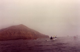 We paddled down the south jetty against a tide current and out into the open water. At times, depending on tides, swells, and boat traffic, the exit of the channel can be pretty rough, but it was no problem for this trip. We paddled out to the red buoy marking the bay entrance and were followed by several large sea lions that swam out and climbed on the buoy (avoiding sharks maybe?) At the buoy we headed south. The ocean was fairly glassy and smooth once we left the channel outlet with small swells coming from the SW. The first part of the trip was not that enjoyable, because I was worried about keeping up. I was paddling an SOT (Heritage Sea Dart). There were several fast boats and I was afraid they were going to end up towing me by the end of the trip. However by the end of the trip the fast boats had slowed way down and it was more pleasant watching the scenery at the lighthouse at Point Loma.
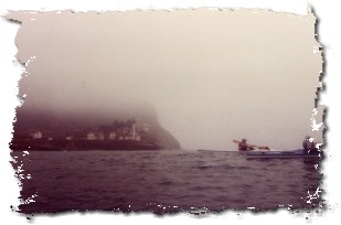
As we neared the point it got quite a bit foggier and the historic lighthouse high on the mountain was not visible. The government built the first lighthouse high on the point where it is often too foggy to be useful. The newer lighthouse was visible today and there was the constant honking of a foghorn. It felt a little bit like a real sea adventure paddling by out in the fog with the horn blasting. There is a large wrecked sailboat piled up on the rocks right at the point to testify that it is someplace to take seriously in bad weather. For our trip, for the most part, the waves were small, although there were a few very large swells when we were near Cemetery Point. When we broke around the Pt. Loma we got into a stiff wind, and choppy water. This lasted until we were in San Diego bay and then there was the usual boat wakes from the pleasure boats and traffic in the Coast guard, Submarine and Navy Yards.
Useful GPS Coordinates:
End of Mission Bay Jetty --- N 32 45.487 --- W 117 15.573
Light House Point Loma --- N 32.39.869 --- W 117 14.779
Shelter Island (Sandy Beach) --- N32 42,878 --- W117 13.511
Accommodations:
Thousands of places to stay and eat in San Diego. Rest rooms at the launch at take out. This trip requires a car shuttle. There is plenty of parking early in the day at both locations.
Directions:
Take I5 to Sea World Drive. Follow Sea World Drive west, until just past Sea World exit right onto West Mission Bay Drive. You can launch from Bahia Point.Turn north into Gleason Road off West Mission Bay Road and continue without making the left into the hotel or the right into the kiddy swim area (no yaks allowed). Paddling from Bahia adds about 1 mile to the trip distance.
Trip Details
- Trip Duration: Day Trip
- Sport/Activity: Kayaking
- Skill Level: Intermediate
- Water Type: Open Water/Ocean