
Powhatan Creek in Virginia
Trip Overview
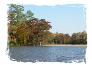
Powhatan Creek cuts through the clay hills of subdivision-crowded James City County, VA, first pooling in long swamps, then threading through freshwater marshes before emptying into the tidal James River. This surprising little creek has managed to sculpt a wide flood-plain which is so low and wet that the developers have left it as a green-swath through the county. The lower creek is a magnet for local paddlers who want a scenic trip without being exposed to the raw power of the James River. My last trip to the Chickahominy River mouth was pushing the envelope of what is reasonable for late Fall so, like a monk, I had come to Powhatan Creek to study humility. My less than ambitious plans were to enjoy the fall color, look for some ripe persimmons, and see how far up-creek I could go.
I put-in at the Jamestown Yacht Club in partly cloudy weather with a moderate wind from the NW. The days air temperature would reach almost 70F, but the water was now below 60F; sure trouble on a big river if you capsize without a wetsuit. The tide was rising and the current was strong for our area, about 2 mph. Paddling out of the marina basin, I turned left for a free ride up-creek.
In this area, the creek winds through marshes between wooded shores separated by a quarter mile. The fresh-water marshes were flooded and as threadbare as an elderly Chinamans beard. Virtually all the marsh grass had died, broken off, and was on the bottom somewhere being recycled. A few turkey vultures were wheeling overhead, and a hawk, and great blue herons were spotted. I could hear kingfishers strafing the distant woods. A cormorant erupted from the water between paddle-strokes like a submarine-launched cruise missile, as surprised as I was.
The trees were in full color, but the more thickly wooded left shoreline was too distant and noisy from mansion construction to really appreciate. To the right were a few established homes on lower banks, followed by a bulkheaded canal which could have been transplanted from Poquoson. Of course I loved being on the water, but by the time I reached a small marina, I had just about given up on the scenery in Powhatan Creek. But a back-bending turn to the left brought me past some smaller homes with purple martin houses and a porcelain toilet used as a whimsical planter. Attitude isnt everything, but it really counts, and I just knew things were going to get better. Almost immediately the creek narrowed so that both attractive, wooded shorelines were within comfortable viewing distance. The homes become sparser and retreated behind the trees and marshes, leaving one or two dilapidated buildings for those shoreline character photos. For perhaps a mile the scenery is really exquisite. I passed a couple in a canoe who told me theyd seen a flock of swans.
About a quarter mile before the Rt. 31 (Jamestown Road) bridge, in the middle of the creek stands a large and impressive bald cypress tree, clearly visible even on aerial photos. Its so old that half of it is missing and the core has rotted out, yet paradoxically, it appears to be thriving. Each branch off the main trunk is as large as a medium-sized tree.
Orange American persimmon fruit hung nearby. Recent frosts had released the enzymes which soften them, so I tried one. The flesh was melting sweet, but the tannins were still so intense in the skin and surrounding the large seeds they turned my tongue to shoe leather. My throat was left feeling as scratchy as if I had vacuumed the living room carpet with my mouth. I only wish that the squirrel that stripped the green Asian persimmons off my yard tree this summer would have suffered proportionately.
After passing Powhatan Creek Park on the up-creek side of the small Rt. 31 bridge, the route gradually turns into swamp. Its a little depressing at first. Many of the trees had already lost their leaves or were dead to begin with. The feathery needles of the bald cypress almost covered the water surface, giving it an undeserved impression of dirtiness. Theres a deep main channel, when you can find it, but the tannin-stained water spreads out into a wide flooded forest which appears to offer many routes. The current is sometimes a help in swamps, but it had puzzlingly died away. Altogether, this area gave an impression of being the most unappealing yet likely place to end up spending the night. But I had a waterproof GPS and spare batteries, and was game to be just a little lost for a few hours, so I continued.
Twice I startled deer on the flooded shores, standing up to their knees in water. Escaping through the shoulder-deep water they laboriously lunged and plunged, lunged and plunged, until they were out of sight. Perhaps they had found some greenery I didnt see, or were waiting for dusk so they could consume the landscaping in the nearby residential areas. Although it feels quite isolated here, less than 1/8 mile of wet slogging to the west will take you to homes which can sometimes be glimpsed through the trees. To the east are some low clay hummocks that are available if you need a dry place to stretch your legs.
Only a few species of bushes and trees retained any green leaves at this point, but there were rose-hips, small pine-cones of the common alder, and nuts of the bald cypress. There was now an opposing current which sometimes cascaded over impounding deadfall. I cursed the apparent 1.5 hour early passing of high tide, fearing that the water levels would drop so much Id have to walk out of the swamp if I lingered too long.
As I passed within two arm-lengths of a small dry island, a large mound of fur shifted, took a few waddling steps, and slipped quietly into the water. Like many wildlife encounters, it was over before I knew what was happening. It was a big beaver with a body as large as a medium-sized dog. Capybaras may be the worlds largest rodent based on average sizes, but a 60 lb adult beaver comes close, and viewed at eye-level from a kayak is plenty impressive. Strangely, there appeared to be no nearby lodge or den.
If there was a main channel I had lost it. Its probably more useful to think of the creek in this area as a braided stream that may be hundreds of yards wide. I paddled, poled, waded, and picked my around the deadfall. Getting upstream became a puzzle in which the winner does the least amount of work while doing the least wading through ice-water. Even though my rudder kicks-up nicely when it hits a log, I had to fold it away because it kept pinning me in tight turns. My Prowler 13 was too long and heavy for sensibly negotiating deadfall. But since you have to make a lot of entries and exits, a short, light, rudderless SOT seems like the right tool for the job if youre into this sort of masochism.
The water visibility got clearer with only a hint of tannin stain. The dominant vegetation on the firm, sandy bottom looked like a giant grass with wide blades. Portages over the submerged land were mushy due to a peaty layer. Little opened white clam shells sat on the bottom. The water was cold, but a recent hard frost had gotten rid of the last of the summer creepies like mosquitoes, flies, poison ivy, and chiggers. Odd flickering patches of white began appearing in the woods in front of me. If the couple in the canoe hadnt warned me earlier about the swans, I probably would have been a little scared. Facing multiple deadfalls with only 20-30 clear feet between them, outnumbered by swans, and still worried that the swamp was going to empty without me, I turned around.
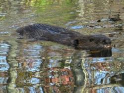 The big beaver was sitting on his island. My hand twitched as I stared at his rich, creamy fur, the conditioned reflex of a cat owner. He slipped into the water, but I stayed to see if he would pose for a few pictures. His body was over 3 long, and the tail extended his length another 2. He circled his island and, if I made any motion or noise, slapped his tail and dove. But he quickly rose to the surface, circled, and started aggressively slapping the water without diving. I guess this was beaver-ese for, This is my spot!. The beaver Ill call Woody had absolutely no sympathy for the difficulty of taking photos in dim light of a moving animal weaving between stumps and bushes. Those cute little velvety ears were contrasted by disturbing eyes like black marbles that seemed to never blink. Altogether, it was strange for a wild animal not to flee a human, but perhaps in my kayak I was just an ugly deer and this territorial display was repeated several times a day.
Moving off, I stopped 50 away and looked back. In that short time, Woody was already sitting upright on his dry island, with his tail folded beneath him like a seat cushion, preening the fur on his underbelly. He was just so darned BIG, he could have been a Narnia beaver-person sitting in front of a fireplace. I dont know what sad story brought Mr. Ive had enough and Im not going to take it anymore to his dim little island, but I fear his bones will be sitting there next spring.
As I headed out of the swamp the current vanished again. Oops. This is when I realized the tide table was correct all along: in clambering upstream I had gained the few feet of altitude which lifted me above any tidal influence (and thats what the Powhatan Creek Park pamphlet meant by riverine swamp). By leaving the swamp early I had not only missed exploring the upper swamp but would be heading back too close to slack tide for a free ride. So I took my time on the way back, taking pictures, drifting, and really looking at things closely. A medium-sized woodpecker was excavated a deep hole in a dead tree so decomposed that the dark brown sawdust rained down in an almost silent torrent. Swamp rose bushes were bare of leaves but covered with bright red, smallish hips like Xmas ornaments. Outside a very seedy core was a thin layer of mildly sweet flesh. The brown nutty cones of the bald cypress were finally opening: strange little grenades seemingly frozen in the act of exploding, yet which disintegrated with a touch. Despite the cold water, large turtles were still active enough to bask on logs in sunny areas. Whatever mysterious incentive had earlier brought the deer to the edge of the cold, wet channel hadnt brought them back yet.
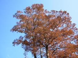 On the way out of the swamp, I stopped to admire some large bald cypress trees that I had missed on the way in. Im not one to disrespect bald cypress trees, but their fall color on this day was limited to a brownish red which made them look like old Xmas trees needing to be dragged to the curb. Since they dominated much of the shoreline along Powhatan Creek, the fall color was patchier than Id hoped. But today, like most paddling days, turned out differently and better than I imagined. I also stopped at Powhatan Creek Park near the Rt. 31 bridge. Its quite nice. Theres parking, a few informational placards, a trashcan, and lot of non-muddy options for putting in.
This is a trip of significant local interest for scenery and wildlife. The described trip was 8 miles and probably about 4.5 hours.
Lower Powhatan Creek: I would choose between the down-creek Jamestown Yacht Club and the up-creek Powhatan Creek Park put-ins based on the tides. All the people I met put in at Powhatan Creek Park, and were paddling against one of the stiffest tides in our area trying to reach the lower creek. That would be no fun for a beginner. I only occasionally meet other paddlers on my trips, rarely on week-days, but on this weekday trip I met 3 groups: a single kayak, a couple in a canoe, and a tandem kayak. Paddling on Powhatan Creek on a summer weekend may be so popular that you can walk across the boats. The people of James City County would have more choices if hand-carry put-ins were allowed along the Colonial Parkway.
Upper Powhatan Creek: If you want to go up-creek to visit the swamp, start at Powhatan Creek Park. After a short distance, tides wont be an issue. If you make it to Rt. 5, from old USGS aerial photos it appears that the road impounds the creek above Rt. 5 enough to make a swampy lake. But I havent explored it yet.
Accommodations:
Jamestown Yacht Club. (port-a-potty this time of year)
News flash! The Daily Press reported that the Jamestown Yacht Club was just sold to James City County to preserve it as open space. I dont know how that will affect accessibility. This winter, I would expect no changes. In the spring, try calling ahead.
Powhatan Creek Park - no services
Fees:
Jamestown Yacht Club ($8 fee, honor box this time of year)
Powhatan Creek Park no fees
Directions:
With a map of James City County, VA, in hand, follow Rt. 199 to Jamestown Road (Rt. 31). Head SW until you reach either Powhatan Creek Park (on your right just before a small bridge which passes over Powhatan Creek) or the Jamestown Yacht Club (on your left, a block before the Jamestown museum and two blocks before you drive onto a ferry).
Resources:
Aerial photos and topo maps from http://www.terraserver.microsoft.com were useful for the tidal portion of the creek.
The CBOFS wind forecast for the Chesapeake Bay area can be found here
I use http://tbone.biol.sc.edu/tide/ for tide predictions.
Trip Details
- Trip Duration: Day Trip
- Sport/Activity: Kayaking, Canoeing
- Skill Level: Beginner
- Water Type: River/Creek (Up to Class II)