
Pocaty River in Virginia
Trip Overview
 Sunday afternoon was the perfect day for a short trip on the Pocaty River here in Southern Virginia Beach, Virginia. The Pocaty is a tributary of the larger and longer, North Landing River.
My launch site was a small bridge over the Pocaty River on Blackwater Road in rural Virginia Beach. There was plenty of room for parking four or even five vehicles on the road's shoulder. I was very happy at finding an open spot and with no formal boat ramp, thus avoiding a ramp fee. Free and accessible, what more could I ask for? I encountered a lone fisherman trying his luck at the bridge. We spoke for a few moments and I was off, heading almost due East. My destination was the Nature Conservancy platform erected at the mouth of the Pocaty as it feeds into the North Landing River, a round trip of only about 5 miles.
I paddled through a small straight area for approximately 1/4 mile. While navigable, this stretch required lots of weaving through fallen trees and limbs courtesy of Hurricane Isabel no doubt. After that stretch, the river widened and shot off into smaller arms to be explored. The main river was not hard to follow and I pressed on heading for the platform.
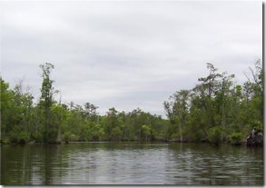
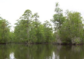
The area surrounding the river was widely varied. The area closest to the put in was extremely swampy with no inviting areas to pull ashore and rest. That soon gave way to a forested shoreline with more solid ground. There are many trees growing from water in little islands and scattered glimpses of color from bright flowers growing at the water's edge. I got glimpses of cornfields through the trees on the Southern bank. The Northern bank was simply undisturbed and beautiful as the surrounding area there is a preserve.
 The wildlife I saw consisted mostly of turtles, jumping fish and birds. Every turn or bend brought me upon turtles sunning on logs. Ahead of me I could see fish breaking the surface or leaping from the water entirely. The day was overcast and threatening rain. I did encounter some sun but only briefly. Maybe this was the reason that I did not see more snakes. Mostly the snakes keep to the water's edge and are simply traveling from one place to another. They are interesting to watch and seem to adhere well to a "if you don't bother me, I won't bother you" attitude. At one point there was something surfacing in the water around the boat. I have been in other tributaries of the North Landing where I have seen river otters at play. This may have been a river otter but usually they will surface to look around out of curiosity. Whatever this was had no interest in me whatsoever. The birds in the area proved to be the best fishermen, dropping to the water's surface in long swoops and coming up with fresh meal of fish almost every time.
As I neared the North Landing River I could hear the far off whine of jet skis and motorboats. Still, I encountered only two boats during my entire trip and they were very courteous in dropping their speed and leaving only minimal wakes. The wind was coming out of the Southeast at about 10-15 mph and this became the overriding factor during the last 1/2 mile to the platform. Upon reaching the platform I decided simply to turn around and head back. The platform's dock was well above the water's surface and I am not as adept as I'd like to be getting in and out of my kayak from a dock situation.
I started my trip back Westward with the intent of taking some photos. My digital camera proved cantankerous on the way back but I did manage to coax five or six pictures from it, mainly from the larger parts of the river. I could have stopped for a rest on the way back as there were several places to do so. There was a small dock built at the end of a dirt path coming out of a field of corn. While the land was marked "no trespassing", I surmised a short rest at the dock would not cause any due alarm or harm. Additionally there was another area where a small finger of water ended in a dirt bank adjacent to this same cornfield. There were several hunting blinds some of which could still be boarded with safety. Several of them were clearly not going to be used ever again.
It was a very nice trip and easy to do when one is crunched for time as it only took about 2 hours total to paddle to the platform and return. A map was necessary as the river does branch off and it was not always clear which was the correct way back. There were plenty of unique areas to explore off of the main river although I left most of them to explore another day. The temperature was about 77 degrees and the water was similarly warm. I decided to call it a day upon returning to the bridge even though the river continues on West of the bridge and was very enticing. That was to be an adventure for another day.
Accommodations:
Virginia Beach is loaded with hotel facilities. The closest to this area would probably be in the Lynnhaven area. There are campgrounds available but I do not have any information on them.
Fees:
There are no fees or permits required for this area if you put in at the bridge on Blackwater Road. If you decide to approach Pocaty from the North Landing River you will have to use a marina with a $2-$3 ramp fee for kayaks and canoes.
Directions:
The Pocaty River can be accessed from Blackwater Road in Southern Virginia Beach. From route 264 one can the Independence Boulevard South exit and proceed approximately 5 miles to Princess Anne Road and take a left. This will end at North Landing Road after another approximately 4 miles. Turn right on North Landing Road, continue on over the Intercoastal Waterway to a left hand turn on Fentress Airfield Road (approximately 4 miles from the Princess Anne Road turnoff). Once on Fentress Airfield Road, the next left is Blackwater Road. The bridge is just past the intersection of Blackwater Road and Pocaty Road which is only about 4 miles from the turnoff from Fentress Airfield Road. If you prefer to come to the Pocaty River from the North Landing River, there is a marina on West Landing Road which is about one mile North of the mouth of the Pocaty. Be aware though that boat traffic on the North Landing is heavy in the summer and since it is part of the Intercoastal Waterway, there are some very large vessels moving about.
Resources:
There is a book authored by the owner of a local outfitter called "The North Landing River and it's Tributaries" by Lillie Gilbert of Wild River Outfitters in Virginia Beach, Virginia and coauthored by Vicky Shufer, a naturlist. This book contains the information on the Pocaty as well as many other similar paddles. The map in the book is good enough to navigate the river but a more detailed map where you could note landmarks would be much better.
Trip Details
- Trip Duration: Day Trip
- Sport/Activity: Kayaking, Canoeing
- Skill Level: Beginner
- Water Type: River/Creek (Up to Class II)