
Platte River in Missouri
Trip Overview
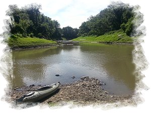
Platte Falls Conservation Area has a set of boat ramps that straddle a small hill such that you can put-in, paddle 2.7 miles and take-out about an hour later. Your walk to the first ramp to fetch your vehicle and drive back to your canoe will take less than 5 minutes.
On this date, there was barely a current with pleasant breezes that rippled the water and made it necessary to paddle and rudder steer to get past many downed trees and snags. The shore was mud that sloped up gradually on all sides with a band of grasses and treeline above.
There were few places to get out of the boat without feet wet. Saw fish jumping, a beaver and small wildlife. No mosquitoes. Muddy water. Heard some jets from nearby KC airport and a few cars at the end. Otherwise the trip was relaxing and scenic.
The shortness of this route would make for some good canoe racing.
Accommodations:
None, other than pit toilet.
Fees:
None
Directions:
I-29 NW past the airport to the 2nd Platte City exit, which is County Road HH. First left onto McKnighton becomes a gravel road into the area. Half a mile and the road forks in 3 directions.
Right: upstream ramp.
Straight: toilet.
Left: downstream ramp.
Launches:
Left: Downstream Ramp.
Trip Details
- Trip Duration: Day Trip
- Sport/Activity: Kayaking, Canoeing
- Skill Level: Beginner
- Water Type: River/Creek (Up to Class II)