
Oswegatchie River in New York
Trip Overview
I had been interested in paddling the Oswegatchie River ever since an acquaintance told me about it two years ago. My wife and I decided on Labor Day weekend for our getaway. We chose, as many do, to put in at Inlet and paddle upstream for two days, then back out on the third.
Having been a dry summer, the river was quite low and I was somewhat apprehensive about it being navigable. A post to the Pnet site led to some reassurance that it would be fine.
Day 1
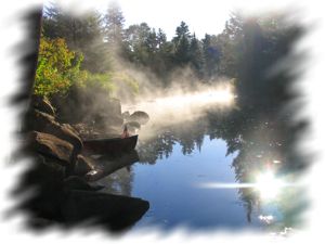
We arrived at the Inlet put-in by 9 a.m. and were on the water by 10. The Oswegatchie in this section runs slowly enough to paddle upstream without too much effort.
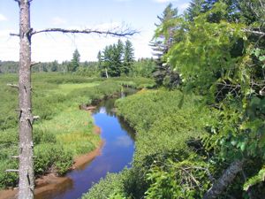
It is a very pretty section with stands of towering evergreens and a rocky shoreline. This section soon gives way to a huge meadow where the Oswegatchie snakes through it, with numerous twists and turns, reminiscent of switchbacks on a steep hiking trail. In this section a couple miles of paddling will only bring you a half mile or so further upriver as the crow flies.
Unlike the wide open section in the beginning, this one is almost claustrophobia inducing, with seemingly endless stands of alder thicket hugging the banks of the river obscuring views of anything beyond the narrow river channel.
This section made us glad what we were in a reasonably nimble Mad River Explorer 16. A longer tripping canoe would not be much fun here.
After about an hour of paddling the river opened up somewhat and we reached the High Rocks campsite where we stopped for lunch. There was already a party camped here at one of the sites and it was too early for us to consider making camp, so we climbed to the top of the rocks to take in the view and enjoy our lunch. After finishing our lunch of dried chorizo and cheddar on Triscuts and GORP, we stretched out on the rocks for a quick nap.
We were underway again by 2:00. Soon after passing High Rock, the river enters the forest and the views open up again. By this time we had carried over a 4 or 5 beaver dams, but in each case we were able to get out and slide the canoe over the dam without unpacking it, so it wasn't too much of an inconvenience.
Our long lunch at High Rock put us a bit behind schedule as we had planned to make it at least to one of the campsites near Wolf Creek Jct. As the shadows lengthened we started looking for a campsite. We were waiting to reach Griffin Rapids and checked out a few campsites along the way that were overgrown or otherwise unappealing.
We passed a paddler and his teenage son coming downriver. He informed us we had already passed Griffin Rapids (What? We didn't see any rapids!) and that one of their favorite campsites on the river(#28) was just ahead. We thanked him for the info and set out for said campsite.
Arriving there, we determined that it was indeed a very pretty spot, on a rocky section of the river with mixed hardwood trees and a few tall pines shading the site.
The paddler we met had warned us that there was a hiking trail that passed practically through the site. We decided to make use of it the next morning and hike to High Falls rather than paddle there and back.
 Day 2
Day 2
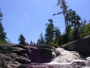
After breakfast we grabbed some water and a snack and hit the trail to High Falls. It was a pleasant, relatively flat walk and we were the only people on the trail. It was a tad over 3 miles to High Falls by foot and we were there in a little over an hour.
The falls were scenic and my wife lounged on the rocks while I snapped several dozen photos (thank goodness for digital cameras). I had heard that the campsites here could be crowded, but there was nobody camped here that we could see.
A group had come downriver earlier while we were eating breakfast and said they had spent the night at High Falls. Several of the guys mentioned they were fighting off hangovers. Well we found the evidence of their party at the shelter closest to the falls. The shelter was scattered with the remains of a 30 pack of cheap beer, an empty quart of lousy vodka, empty cans and packaging from their meals and a few piles of vomit.
It really galls me that these inconsiderates can bring all that stuff upriver, but won't pack it out. Unfortunately we had nothing along that we could use to carry out the garbage so we had to leave it behind.
We were back at camp by 11 and packed up and on the river by noon. Even though it isn't a difficult paddle going upstream, paddling with the gentle current is considerably easier and with the current on your side, a few of the beaver dams could be crossed without getting out and pushing.
We still had one more day on the river so we headed for High Rock to see if the campsite was available. It was, but with a threat of thunderstorms in the forecast I didn't feel comfortable spending the night on the highest point for some distance, so we moved on to the next site (#42) which was a pretty site in its own right.
 Day 3
Day 3
We were on the river by 8 am and it looked to be another beautiful day in store. As we passed the campsite at Sam's Curve we disturbed a Great Horned Owl that was perched on a branch hanging over the river. Unfortunately, the majestic animal flew off before we could snap a photo. Moments later we rounded a bend to see a Great Blue Heron about 20 feet in front of us. He seemed surprised by our sudden appearance and hesitated long enough for me to snap a photo before he took flight.
On the return trip we started counting the beaver dams and totaled 8 between our first campsite and the put-in. None required a portage.
It's not a long paddle from campsite #42 to Inlet so we were back at the put-in by 10:30.
Accommodations:
Nearby:
Little Wolf Campground - Tupper Lake
Tupper Lake Motel, 255 Park St, Tupper Lake
On the river:
Over 30 designated campsites between Inlet and High Falls.
Outfitting:
Mad River Explorer 16 RX.
Fees:
None
Directions:
Northway (87) to Rt 28. Rt 28 to Rt 30N to Tupper Lake. From there take Rt 3 west through Wanakena. Continue to DEC Oswegatchie access site on Inlet Rd. Stay on dirt road, make right at bridge and road ends at parking area.
Trip Details
- Sport/Activity: Canoeing
- Skill Level: Intermediate
- Water Type: River/Creek (Up to Class II)