
Okeechobee Waterway in Florida
Trip Overview
The Great Paddle Across Florida Kayak Expedition of 2006
By Tom Schneider and Dave Bracknell
 Dave read an article about a cross-Florida water route called the Okeechobee Waterway in the Palm Beach Post in December 2004. He remembered a friend many years ago talking about doing the route in a sailboat. Having acquired several Scupper Pros a year or so ago that he used once a month or every two months, he thought it would be neat to do this trip via kayak and maybe even do it for charity. Thus was born The Great Paddle Across Florida Kayak Expedition of 2006.
Dave recruited an old acquaintance, Stew Sherman, who immediately said yes to the trip idea. They both talked it up with friends and relatives but no one else wanted to go and most thought it was a crazy idea. So, Dave posted a message on the Paddling.net message board and got several response, two of which said they want to come.
 Anita Allen of Coral Springs, Florida had wanted to do this trip for several years but couldnt recruit anybody. Tom Schneider of Merill, Wisconsin thought it was a great idea and insisted (Dave tried many times to dissuade him) on joining. Dave wanted Tom to do some more scenic routes in Florida and was afraid Tom would be disappointed. He was wrong the trip was very scenic and an awesome experience for all of us.
Stew met a paddler up near Jupiter Island Jack Roberts who also wanted to join the group. He had plenty of canoe camping and kayak experience. Thus we have the team 4 men and one woman. We contacted the American Cancer Society and asked if we could raise funds for one of their events and they linked us up with a Relay For Life event. So now we had a trip and a cause.
The group in Florida trained for the trip and kept Tom apprised of the training runs. Dave still tried to get Tom to not come (there are better places to visit by kayak in Florida!) but Tom was sure he wanted to do it. Then Toms brother Jeff also said he wanted to come but as a support person he would follow the route in a truck and help carry supplies and re-supply as necessary. He was invaluable for all of us on the team. Although we could have probably made the trip without a support person, Jeff made life a lot easier for all of us. He became known affectionately as The Stalker. Dave made sure we all had nicknames.
On the morning of the 18th we drove from Ft Myers across the toll bridge to Sanibel Island. A local paddler, Stan Holoquist, joined us for the first leg of the trip. We were in the Gulf of Mexico and it was my first experience to see an oyster shell beach. After pictures were taken, we launched into the salt water and paddled under the bridge. We paddled into an out flowing tide. We passed a small island and noticed Jeff had his video camera on a tripod near the palm trees. This became a common sight along the trip, hence the name The Stalker. We saw a couple of dolphins in the Gulf as well as pelicans.
Stan led us though a canal past some very nice homes to keep us out of harms way in the main boating channel. Those boats dont slow down. There are signs with speed limits in certain areas, especially where manatees gather. The limit was 25 MPH and I can assure you none of us came close to breaking the law in our kayaks. Our first day was pretty quick. We paddled 19 miles and had two breaks. We made it back to the motel Best Western on the riverfront. It was an excellent location for kayakers we made special arrangements to keep our kayaks on the grass next to our first floor rooms. Water to our rooms was maybe 50 feet with a nice sandy beach. There was a beautiful sunset and a fireworks display in Ft Myers that night while we had supper and relaxed.
 Feb 19th, Toms birthday #57, and we had to pack the kayaks with a full load. Jeff would be following us and had the maps of the campsite we were paddling to that day. The kayaks were heavy now for the first time. Jeff inherited some of the gear to carry in the truck. Water? How much do we carry? This became an issue and Jeff kept us in fresh water the whole trip as well as Gator Ade and a few beers as necessary. It was warm and the Caloosahatchee River is very wide near the hotel.
Stan met us at 8:00am and only planned on paddling to the I-75 bridge. He called his wife and asked her to meet him at our campgrounds, The Caloosahatchee Regional Park, so he could paddle with us the remainder of the second day. Jeff radioed Tom and asked our position. We were in the middle of the river over a mile from shore and were spread out maybe by a half mile. Tom had stopped to take a picture of a lighthouse when he radioed. He didnt have a clue where the lighthouse was, but informed Tom he was standing by two palm trees a short one and a tall one! Tom responded that maybe those were the only two palms in Florida, but couldnt see them. It was while taking those pictures of the lighthouse Tom noticed the pull of the river. Everytime you stopped to take a picture you not only lost speed, you also lost distance. There was a .7 MPH current as measured with the GPS. This meant for every six hours on the water we had to make up for 4.2 miles flowing against us. It might not seem like a lot, but it sure added up when it came to fatigue.
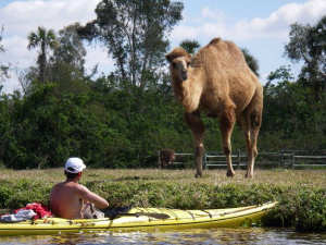 We paddled both sides of the river as our interest was piqued by something. As we paddled on the north side of the river, Tom was about 10 feet to the left of Stew and hit something. All of a sudden Toms kayak raised out of the water and started to tip to the right. He braced and there was a huge gray mass that came out of the water followed by a splash. Stew looked at him and he was wet from head to spray skirt. Tom started to laugh and Stew asked what had happened. I was picked up and saw my first Manatee Tom told him. The things that will happen on your birthday! It wasnt long after that we saw a camel on the south side of the river so we stopped to take pictures there too. There was a Llama near the camel, but it wasnt interested in us like the camel was.
Day 2 was a tiring day. Although we had only paddled 17 miles and passed through our first lock, the WP Franklin Lock, we felt like it was longer. Jeff had brought a cart for our gear to haul to the campsite at Caloosahatche Regional Park. The site was about a quarter of a mile from the river. We had to make a couple of trips to get all of the gear to the site. We cable locked all of the kayaks together as we had done by the hotel the night before.
Jeff helped us set our tents up and it was nice to take a shower and get the layers of sunscreen off. We prepared our meals and went for a late night walk on the trails in the park. Of course there was a suggestion to do it without the use of lights on and we did manage to find the river and the kayaks, but we also missed a juncture in the trail and got lost. We saw a red light and walked straight towards it. It was Jeff, in the campsite playing with his flashlight. It was a lucky coincidence.
Day 3 Jack made omelets in the morning and we saw some feral pigs in the campgrounds. There were also wild orange trees as well as tangerine and grapefruit trees growing in the park. The oranges were sweet. We didnt try the others. Packed up and moved gear to the kayaks. There was an early morning fog hanging over the river and we applied sunscreen, stretched, and slipped silently into the water and the mist. The water was like glass, but still moving west. We paddled east at 8:30am. We saw our first alligator today and rescued a small turtle that was caught on fishing line attached to a log. An elderly woman brought this to our attention. At the Ortona Lock, Jeff was with the lockmaster when we approached. The buzzer wasnt working so he gave us instructions via the radio. Along the way we met our second local paddler, Don McCumber. Don was paddling a stitch and glue kayak and paddled with us to the Meadowlark Campgrounds. We paddled into a small channel to get closer to the campsite. We loaded the gear in the truck to move it to the campsite. We were in a RV type park and the people camped there were very nice. Bob Dean, another local paddler, gave Don a shuttle back to the landing he had joined us at so we could get set up and try to relax. We took showers and locked up the kayaks. Too tired to cook, we went into town for pizza with Bob. It seemed like a long drive, but then when youve just paddled over 25 miles, everything seems to take forever.
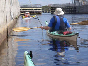 Day 4 We are up early and one of the campers across the road from us has made coffee for us. We boiled water for oatmeal and packed our gear. The tents are wet with heavy dew. When we paddled out into the river there was an eerie fog over the entire area. Tom checked the drift again. It remained constant, .7 MPH. As we started up the river we were less than a mile from the campground and a gun shot rang out. This was at just past 7:30am. We paddled about 5 miles and were met by Bob. He had paddled down from the Moorehaven Lock. Bob paddled with us all the way to Clewiston and then back to Moorehaven. This was our longest day at 27.8 miles, but we figured Bob paddled 34 miles that day. Jeff videoed us in the lock and Anita let go of her rope and they shut the lock until she hung on again. The locks have ropes that hang from the rails above. The gates are opened slowly to allow the lock to fill or empty. The ropes keep the boats from being washed around. Even the big boats must do this. They dont like kayakers trying to do white water maneuvers in the locks, so Anita was scolded.
Entering Lake Okeechobee was very different from what we had been paddling. There is a levee around the lake and a channel dredged around the outer perimeter for larger boats. Towards the lake side is a layer of trees and islands separating the lake from the channel. We saw four more alligators here as well as several ospreys. The ospreys were near their aeries and paired up. There were many different types of ducks and birds along this stretch of the lake. The trees were an Australian variety that were poisoned off because they were destroying the natural habitat. The lock entering Clewiston was open and we said our goodbyes to Bob. It was already past 4:00 and we were worried about Bob getting back to Moorehaven, but he said hed make it before dark. We were staying in a hotel tonight (Roland Martins), but we still had to set up the tents to let them dry out from the morning dew. We were all pooped. It didnt take long for the tents to dry and we put them back in the kayaks and locked them to the light pole. We checked into our hotel rooms and took showers, then made our way to the Tiki Time where its always 5:00pm. We had supper there and contemplated the next day. We were over half way across Florida, but still had Lake Okeechobee to cross, our second longest day, and nowhere to get out of the kayaks.
Day 5 We werent the only early risers. There were a lot of fishermen heading for breakfast too. We mentioned we were kayaking straight across the lake and people looked at us like we were crazy. That actually made us more determined and happy to do it! We ate breakfast in the restaurant as a matter of practicality and started to load the kayaks. We carried extra water and there were a number of ideas as to what to do to drain our bladders. As Dave insisted, Dont carry the same color Gator Ade if youre using a Gator Ade bottle for relief purposes. Tom also found out it wasnt a bright idea to lock the kayaks under a tall light pole. A heron can leave a large pile of dodo on your kayak!
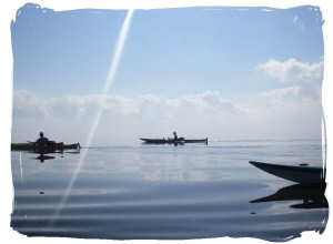
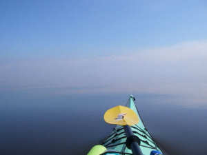 We got an early start and the water was calm. We were warned about the boats, but found that wasnt a problem. Once we left the channel we were in a straight line across the lake. We stopped at 8 miles out for our first break and then again at 12.5 miles the halfway point. It was eerie again to be in the middle of the lake with no land in sight. The water was perfectly flat. As we paddled, there were times we felt we were hallucinating because the sky and the water seemed to be joined. There was no horizontal line of separation. Dave commented that Tom (out in front) looked as though he was heading off the edge of the earth. At 14 miles we could see a radio tower on the other side. We had just over 10 miles to paddle yet. We stopped at 16 miles for another break and we could see the bridge at Port Mayaca. The last 8 miles seemed to take forever, but we made it across the lake in 6 hours-24 minutes at an overall average of 4.6 MPH, our fastest day.
Jeff went to talk to the lockmaster to inform him we were coming. He informed Jeff we were in the lock. Jeff couldnt believe we crossed the lake that fast and the lockmaster found it hard to believe we actually came straight across the lake. We met Jeff at a landing on the east side of the lock. We only dropped about1-2 feet in the lock. It was hot that day. It was hot in the kayaks all week. We drank lots of water and Gatorade everyday in the kayaks. We paddled another couple of miles after our break with Jeff to a rough campsite. We picked up some water from Jeff and offered him a chance to cross the river, but he chose to camp at a nearby campground. We had paddled a total 27.6 miles and were so very happy to have made it across the lake. It was stressful up until the Lake Okeechobee crossing because we were worried about bad weather the day of the crossing but we had a perfect day almost unbelievable!
Day 6 We got up early and boiled water for oatmeal and cocoa and packed the kayaks. It was early and the sun was just coming up, another beautiful sunrise. We were so lucky with the weather. Stew and Tom shoved off so Stew could show Tom where they had seen alligators when they were training. They might have seen a couple, but those alligators are very shy and disappear very quickly as the kayaks approach. We met up with Jeff to make sure he was ok and then met him later on for lunch at a park. Tom finally took off his PFD because it was chaffing under his arms. He paddled with it on the front deck like the others were doing. It felt odd for him not to have it on- he was a Midwestern paddler with Chota boots on and long pants and PFD and the others were wearing sandals, swimsuits, and cotton t-shirts. At 22.7 miles we were at St Lucie Lock and campgrounds. There was a reporter there to take our pictures. Jeff found out we could leave our kayaks behind the fence near the boat landing and we cable locked them to that fence. The campgrounds gate is locked at night, so we were ok anyway. We moved the gear to the campsite and some of Jacks and Daves friends were there to meet us. We set up the tents headed to the showers to get rid of the sweat and sunscreen. It was so nice to sit down and drink a beer after the shower. We had a nice supper (we caught a ride into town to a BBQ place) and then sat by a fire back at the campsite.
Day 7 Just when you think the worst is over, we woke up to wind blowing out of the northeast. There was a reporter there and instead of loading the kayaks, we put everything non-essential into the truck. It was full. We paddled into the lock and dropped about 14-15 feet. We only had a .3 MPH current flowing east, so with the wind in our faces this wasnt going to help us. As we left the lock we could feel the chop of the waves against the bows of our kayaks. We paddled near shore or on the lea side of islands when we could. We stopped at a park in Stuart to take a break. Returning to the canal, we entered a larger body of open water. The waves really kicked up until we got across and were on the lea side of the mainland heading east. The canal turned southeast and we stopped at a park where we encountered people cheering for us as well as Jeff video taping our arrival.
The people were from the kayaking club Jack belongs to. After a short break, we started our trek to the Atlantic. One of the club members approached on a SOT kayak. She didnt want anything to do with paddling into the ocean, so she headed back to Port Salerno where our trip would end. We paddled into ever growing waves as we paddled out Port St Lucie Inlet out into the Atlantic Ocean. We had to make it into the Atlantic Ocean as our finale so we went out maybe a half-mile past the shoreline. When we made it to that point we were the only craft bobbing up and down in the water out there.
 Turning around, Jack lead us through a mangrove stand so we would be sheltered from the wind as well as the boats in the channel. The water got a little shallow in there, but we made it back to a beach in the intracoastal where the waves from boats and the wind made for some fancy landing maneuvers. There were reporters there and we had a small celebration on the beach, but reality called and we loaded the kayaks on the truck and Jacks van for the trip back to his home. We washed the kayaks there and wrapped Toms for the trip back to Wisconsin. Jeff set up the video camera and we had hamburgers etc.
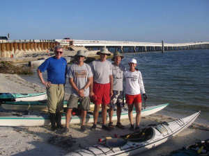
The last day, which we thought would be easy, was a challenge. We had paddled 160.25 miles in seven days. We came together as strangers and left as friends.
To date, we raised over $8,000 for the American Cancer Society and had an awesome experience- something some (if not all) the members of this team never thought theyd do. We hope reading about this adventure will get others to go out and do more/have an adventure but also remember to give back in some way. We also would be delighted to see other groups continue this trip as an annual event we will gladly offer advice and information to them.
I highly recommend this trip if for nothing else to be able to say "I paddled across Florida." It was a great trip but we trained long and hard before doing this and did some kayak/camping training - some of us had never been on an overnight kayak trip nor long paddle before. Going across Lake Okeechobee: People (including highly experienced kayakers) said we were nuts to attempt this but we really wanted to do it. We had great weather but it can be very dangerous if the weather doesn't cooperate - have a back up plan (we had the rim canal as backup) and don't go against your better judgement. I'm glad the weather was good because we were determined to cross the lake...
We set up a Website that documents this trip: paddleacrossflorida.com/
Accommodations:
Hotel rooms and campsites; Campsites were all around $16/night - very reasonable but need to make reservations early if doing this in the winter months.
Outfitting:
Kayaks - 2 Current Designs (Solstice and Gulfstream), 1 Necky Looksha II (20 feet by 20 inches), and two others I don't know the models but sit inside singles.
Fees:
Directions:
West coast of Florida, see maps.google for Ft Myers and Sanibel Island, FL. Also look up Stuart, FL for east coast. I used maps.google.com to plot our route as well as find campgrouds and motels.
Resources:
I used maps.google.com and the Okeechobee Waterway information page maintained by the Army Corps of Engineers
Trip Details
- Trip Duration: Extended Trip
- Sport/Activity: Kayaking
- Skill Level: Intermediate
- Water Type: River/Creek (Up to Class II)