
Muscongus Bay in Maine
Trip Overview
 Muscongus Bay extends south from the town of Waldeboro, Maine, just an hour north of LL Bean. The upper reaches of the bay are protected from open ocean wind and waves, making Muscongus Bay an excellent destination for advanced beginner and intermediate sea kayakers. This review focuses on areas of the bay which are most accessible from the picturesque town of Round Pond, which is located not on a pond but on a natural round harbor located halfway down the east side of the Pemaquid Peninsula.
Day paddles from Round Pond and other nearby put-ins will take you through a haze of colorful lobster pot buoys to a number of closely-spaced and mostly uninhabited islands, with the opportunity to see many basking seals amid the constant cries of gulls and osprey. Muscongus Bay is less developed than many other areas along the Maine coast, so there is very little boat traffic other than lobster fishermen.
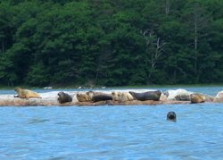 Although camping should be limited to Maine Island Trail sites, virtually all of the islands are available for lunch landings, with many excellent sand and gravel beaches. My particular favorite is midway along the west side of Cow Island, facing a ledge that emerges an hour or two after high tide and is a guaranteed basking site for thirty or more seals. Ledges just above Palmer Island and near Heath Point in Broad Cove are also frequent seal basking sites.
The Goose River, at the east end of Back River Cove, boasts a small reversing rapids which can easily be run in kayaks at one-third tide or above. After going through the rapids, keep exploring to the furthest limit of the scenic little river.
My wife and I just returned from a four day trip to Round Pond. Our itinerary provides an example of the many sights to see and routes to kayak in this area:
Day 1
Drive up Rt. 1 to Damariscotta and take Rt. 130 to the southern end of the Pemaquid Peninsula, stopping to see Fort William Henry and the Pemaquid Point Light House. Then drive up Rt. 32 to Round Pond, stopping for lunch at Shaws dockside restaurant in scenic New Harbor village, filming site for the movie Message In A Bottle.
Day 2
Put-in at the Round Pond public ramp ($2, limited parking, or one mile up the road at Muscongus Harbor ($5, plenty of parking). If wind and waves are reasonably low, as they often are in the morning, paddle around the southern end of Louds Island, then up the east side of the island and across to the west side of Cow Island for lunch. After lunch, paddle to Palmer Island, then cross to the northern end of Hog Island and along the west sides of Hog and Louds Islands to return to Round Pond.
 Day 3
Day 3
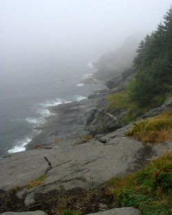
Hike for the day on Monhegan Island. Make an advance reservation with Hardy Boat Cruises in New Harbor to take their combined seal watch and Monhegan day trip. Monhegan Island offers a classic rocky coast with the highest cliffs in Maine, a profusion of wildflowers, and fairyland interior trails through Cathedral Woods.
Day 4
Put-in at Medomak (free beach access at the end of Medomak Rd.) or Broad Cove (free public ramp at the end of Storer Road) and paddle down the Hockomock Channel and Keene Narrows, past a big burned-out ship wreck, to the northern end of Hog Island. Then cross to Palmer Island and paddle along the east sides of Bremen Long Island and Hungry Island to Back River Cove and the Goose River. Stop for lunch just before the reversing rapids if the tide is too low, or at an excellent beach site beyond the rapids if the tide level is OK. After lunch explore the rest of Goose River and paddle home around the northern ends of Hungry Island and Bremen Long Island.
Accommodations:
Accommodations are limited in this area, which in turn limits the number of other kayakers you will encounter on Muscongus Bay. Recently, a great new bed and breakfast opened right in Round Pond, authentically named "The Inn at Round Pond." The Inn offers a gourmet country breakfast and is right across the street from the harbor, a top quality seafood restaurant, a classic Maine lobster pound with picnic table dining, and a souvenir shop with an excellent ice cream window.Fees:
As noted, kayak access is free or very inexpensive.Directions:
See Description above.Resources:
The DeLorme Maine Atlas and Gazetteer provides good maps for back roads and ramp locations. Waterproof Chart No. 102 provides excellent navigational detail for Muscongus Bay. A GPS unit is always helpful.Trip Details
- Skill Level: Intermediate
- Water Type: Open Water/Ocean