
Mullica River - Sleeper Branch in New Jersey
Trip Overview
Sleeper Branch is a small tributary in the Mullica River Basin that flows in the Pinelands National Reserve that we simply call the Pines. Arising from the west of Route 206 and crossing under about a mile south of Atsion this section runs thru swamps and bogs. To my knowledge the river isn't navigable along this stretch. However the one mile of navigable river at the lower end is well worth the 2 mile roundtrip that starts at its confluence with the Mullica river. There's a catch. Generally there isn't enough water to get up river so you need to go on a day when the gauge on the Mullica reads at least 2.5 feet to make the trip worth the effort (waterdata.usgs.gov/nj/nwis/uv/). And with enough water it IS worth the effort.
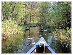
To start you need to put in on the Mullica River. The closest spot being at the end of the graveyard off Rte 542 behind the church (if you know that dirt road) or at Pleasant Mill which is marked with a canoe launch sign. You then go up the Mullica 2/3rds of a mile to the left just before the big bow beach that runs about 100 yards along the west bank. The Sleeper Branch comes in just at the beginning of the beach, if there's enough water it will look like a flooded grassland but look hard and you'll see a flow coming into the Mullica. Make the left and head on up. About 300 feet in you'll come to a partially washed out foot bridge. You can navigate around the right. You'll come into a bog, stay to the left the stream will appear at the top of the bog (only about 150 ft.) and wind off to the left into the woods. You come around the first bend and there it is, a pretty 10 ft. wide snaking channel heading into dense woods.
It's a small stream but one of many such hidden treasures in the Pines, most are short up-river treks of one to several miles that end as small rivulets branching into the woods or a swamp or the dam of a cranberry bog. Some present portage issues, strainers and fallen trees so bring your best saw and some rope. Some, like the Upper Oswego have been well cleared (and navigable for at least 3 miles not just one as stated in Mr. Gertler's excellent book). The Sleeper was free of any obstacles for the first 3/4 mile then I ran into some small downed trees and minor issues of the river braiding thru grasslands till it narrowed to 3-4 feet widths and finally I ran into a stretch riddled with downed trees of all sizes and a difficult portage thru woods strewn with downed trees. There was no reason to even try to go further up river. I was well spent from sawing a few small trees and limbs and was looking forward to the open ride back to the Mullica. The river, over this mile is a beauty. It's about 10 feet wide on average and was about 4 feet deep in the channel.
 Much like the lower Mullica (only a few hundred yards to the east) this stretch runs thru dense White Pine forest that nearly turns day into night. The banks for long stretches are low (at this level) and run deep away from the river. Another foot of water and you can paddle off into the woods. As you approach the confluence with the Mullica the land rises on both sides and opens to fields only sparsely dotted with scrub pines. Given the proximity to Batsto Village I imagine these were man made clearings as just below the last one is what seems to be an old bog. The "orange" foot trail is along the Northwest of the river for the last couple hundred yards with 2 footbridges across the stream that are washed out. The current is mild and the sharp river turns are manageable.
The Sleeper Branch, like several other small streams that can only be enjoyed by going up river is well worth the cardio exercise that you probably need. I took my 12' Old Town Pack and would recommend nothing longer if you plan on going up the full mile. I was greeted at the bog near the end by a Great Blue Heron that was clearly as startled as me. Me by his sudden appearance and leap to flight as I rounded a corner 10 feet away from him and his surprise that someone was coming down the Sleeper Branch which I plan on doing next after the first snow.
Accommodations:
Camping in the Wharton Forest
Fees:
$2.00 for a wilderness campsite at the Mullica River Wilderness Campground that you get to by going another 4 miles up the Mullica; it's worth it.
Directions:
Batsto Village on Route 542 is your destination. Then the Mullica River put-in and up the Mullica .67 mile, the Sleeper Branch comes in on your left.
Resources:
USGA Topo maps are available at Batsto Village Ranger Station
Trip Details
- Trip Duration: Day Trip
- Sport/Activity: Canoeing
- Skill Level: Intermediate
- Water Type: River/Creek (Up to Class II)