
Misty Fjords National Monument in Alaska
Trip Overview
 Revillagigedo Island offers many superb paddling trips but the best is to circumnavigate the 120 miles around the island. This experience will reward a paddler with a bear observatory, hot springs, pictographs, Forest Service cabins, 3000 foot sheer cliff fjords inside the Misty Fjords National Monument, rainforest trails and a Forest Service canoe to explore an alpine lake. And of course, wild Alaskan scenery, driftwood strewn beaches, Orcas, Humpbacks, and no people!
Ketchikan is the main town to fly or ferry into and Revillagigedo Island, known to locals as Revilla, has only 26 miles of road. I started my trip from the Northern end of the road where there is a State campground at Settlers Cove. There is a good launch beach and the shoreline is studded with islands that offer for the most part protected paddling. A ten mile paddle brought me to Loring, which was the original town site of Ketchikan. All that remains now are about 20 homes and locals living life off the grid. There is a lovely short trail that runs to a waterfall. Along the way you pass by a graveyard with stones dating from the late 1800s of seamen that lost their lives here when Loring was primarily a fishing town.
 Just south of the town you enter the Naha Wilderness Recreation Area and you can take a short portage, 100 feet, around a saltwater tidal rapid and paddle the Roosevelt Lagoon. Where the Naha River drains into the Lagoon you can hike up to a black bear observatory, little more than a platform located above a set of falls where bears fish on the returning salmon. Another mile will bring you to Jordan Lake cabin, and if you plan ahead you can book this through the Forest Service, about $30 per night. The cabin is stocked with wood and has a row boat to explore the lake. Beaver dams are plentiful here and it was a pleasure to watch them play.
The next day we hiked back out and kayaked back out onto saltwater. Here you move into the more open water of the west Behm Canal. Indian Point makes a good campsite if weather is rough. A days paddle brought us to Blind Pass cabin on the northern end of the island. The cabins are luxury indeed after a long day and fulfilled my dream of cabin living in the great Far North.
The next day was a short paddling day as we crossed into Bailey Bay and found the trail marker to hike the trail up to Lake Shelokum. The steep short hike follows alongside a waterfall and then skirts around the lakes edge to dead end at a Forest Service shelter and there bubbling down from a steep rock cliff is the hot spring. A small rock pool large enough for three brings heaven to sore muscles. At the end of the day we hiked back down and camped at the trail head. The next day was short too, paddling the scant seven miles to Anchor Pass Cabin. Listening to the wolves howl while we sat around the camp fire was really special. In the morning we watched a brown bear swim across the short channel and disappear into the woods.
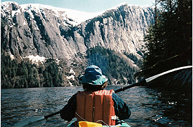
 The next day was a long and fruitful one. We paddled towards the mouth of the Unuk River and were rewarded to see a black bear swimming across the channel ahead of us. We stayed a respectful distance and watched in awe. Next we found the sun pictograph on a steep rocky shore left by native peoples long ago. Then we headed south into the east Behm Canal and made camp at Hut Point, the mouth of Walker Fjord. As we paddled we noticed the land becoming steeper with fewer get out points. However, little can prepare you for the view as you turn into Walker Fjord. Staggeringly steep three to four thousand sheer cliff walls plunge directly into the ocean. The Fjord is narrow and dwarfs you as you travel deeper into the inlet. Waterfalls cascade on all sides and a burst of rain brought hundreds more tumbling down. We made our base camp at Hut Point, beneath a large Sitka Spruce tree that held a magnificent Bald Eagles nest, and spent a couple of days exploring.
Another days paddle brought us to Rudyerd Bay and we camped at Punchbowl Cove. Rudyerd offers the same stupendous scenery as Walker but it is closer to Ketchikan and here we found our first people! The next day we hiked another short and steep trail to Punchbowl Lake and found the Forest Service canoe. Paddling across the lake is not to be missed. We ate lunch beneath a sheer cliff made up of octagonal basalt columns. In the evening we sat at camp in Punchbowl Cove and watched the sun set, turning a three thousand foot cliff, called The Wall, turn pink. The next day we paddled five miles to Nooya Lake trailhead and explored the wonders of that area too.
 Leaving the Fjords we kayaked to another Forest Service Cabin, only one of two cabins on salt water inside the Monument, Winstanley Island. This is a special spot, located on a lovely gravel beach and protected water. The next day we hiked to Winstanley Lake and took the rowboat out and explored. Magnificent scenery again.
Then the home bound bug bit and we headed for Point Alava. Here there is open water and one needs patience to wait out weather. Another cabin though makes this an easy task and the next day with calm winds we paddled into Ketchikan.
In all we spent three weeks on this trip but it can be shortened by using a transport service to drop you at different locations along the way. Southeast Sea Kayaks in Ketchikan offers transportation, kayak rentals and lots of advice. They will also pick you up from the ferry or airport if you come with your own kayak.
There is not a specific book on the Fjords but SE Sea Kayaks sells a Misty Fjords Planning Package for $20 with USFS map, tide table and lots of details. They make it very easy to set up a trip within your time frame. Paddlers with only a week to spend would do well to take a transport to Winstanley Island Cabin and access the most dramatic areas of the Fjords from there.
Outfitting:
Current DesignsFees:
No fees or permits required.Directions:
Ketchikan is on an island. You can fly to Ketchikan direct from Seattle on Alaska Airlines or take the 36 hour ferry ride from Bellingham, Washington.Resources:
Southeast Sea Kayaks in Ketchikan provided kayak rentals and transportation. Also rent bear boxes and sold the Misty Fjords Planning package.www.kayakmistyfjords.com
I would purchase the Misty Fjords Planning package that comes with details of best paddling, hiking, cabins, map and tide table. Available from SE Sea Kayaks.
Trip Details
- Trip Duration: Extended Trip
- Skill Level: Intermediate
- Water Type: Open Water/Ocean