
Manistee River in Michigan
Trip Overview
Manistee River: Deward to Lake Michigan - 165 mile canoe trip down Michigans Manistee River.
By Joseph B Szeremet
In July 2007, my friend Don Potter phoned me and proposed that we canoe the Manistee River from its source north of Grayling, Michigan, to its end on Lake Michigan, a distance of 165 miles. He could not use his usual canoeing companion (his wife Marilyn), because the trip would include 2 difficult portages. Although his Kevlar canoe weighs only 52 lbs., hauling it and the camping gear and supplies needed for a 7-10 day trip would require two strong backs. Like Don, I am a retiree with the time and desire to take on challenging adventures, so I accepted immediately.
A few days later, on July 14, I drove up from my home in Kentucky to Dons home in East Lansing, Michigan. After I arrived we checked our camping gear, purchased enough food to supply us for 10 days, loaded his van and drove north.
That evening we pulled into the Whispering Pines Resort, located on the banks of the Manistee River just west of the small town of Frederic, MI (www.whisperingresort.com). This unpretentious and friendly cabin/campground is owned by Mike and Joyce Howlett. They are experienced paddlers themselves and were genuinely excited that we were going to tackle the full length of the Manistee River.
Many paddlers do sections of the river but the full length is rarely done. Even the paddling guide we were using discourages paddlers from doing the last section. But we were intent on doing the complete trip, so we made arrangements with Mikes take-charge sister, Sharon Dixon, to shuttle Dons van to a campground on Lake Manistee.
Most of the next day was spent shuttling the van. So we decided to start our trip the following morning, Monday, July 16. In the meantime we tested our skills by paddling a mile upstream and back.
The navigable portion of the river actually starts 6 miles upriver in the abandoned logging town of Deward. Although Deward appears on large scale maps, it is otherwise nonexistent, consisting only of weedy, overgrown land that long ago returned to nature. The river at that point, though beautiful, is very shallow and barely navigable so we decided to skip it and begin our trip from the dock at the resort.
That night Joyce took us to the Frederic Inn for what we thought would be our last non-primitive meal for awhile. We had a fantastic pizza. Im always amazed by the fine food you can find in these small northern towns during the summer.
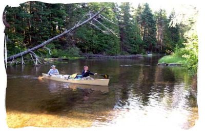
The next morning Don and I cooked up some oatmeal for breakfast, the sticky instant variety. But after we finished, Joyce unexpectedly invited us for a real breakfast of bacon and eggs. This delayed our start but was well worth it. Afterwards we loaded up the canoe, had Joyce take a departure photo of us and got underway.
The river at this point is crystal clear, knee to waist deep and has a sand/gravel bottom. It meanders like a silken snake between banks generally 30-50 feet apart. The surrounding flora consists primarily of densely growing pine trees. Summer cabins are sprinkled along the shoreline. The meandering along this section is tight, narrow and contains many obstacles, mostly fallen trees and sunken logs and tree trunks. This slowed our progress during the first eight miles to the M-72 Bridge.
We were disappointed that it took us 2 hours because we were hoping to average at least 4 miles per hour. Looking back I realize that our speed reflected our unsharpened skills at that point. We slowly improved during the next 14.5 mile segment to the CCC Bridge Campgrounds, our destination for the night .On the way we passed a Girl Scout troop careening their way down the river in 6 canoes and, shortly before the bridge, 4 kayakers on a leisure float. As we were unloading our gear we struck up a conversation with the kayakers. When we told them that we intended to canoe the full length of the river, they were impressed and invited us to have dinner with them at their well-supplied camper. The offer was too good to pass up. Our Ramen noodles and beans and rice could be put off.
Our kayaker hosts were brothers Jerry and Jason Bush, and husband and wife Marcel Danet and Michele Holland. They were permanent residents of the Interlochen area south of Traverse City and were on a short paddling/camping outing. According to Marcel they loved their northern- Michigan lifestyle and would never think of leaving it despite the recent economic down turn affecting their jobs.
Don and I were enthralled by their paddling tales that included surviving dangerous river conditions in Canada and canoeing Michigan Rivers in the winter by paddling the unfrozen parts and dragging their canoes over the frozen parts. Jason offered me a good cigar, Marcel gave me a cold beer and fiery Michele served us one of the best camping meals (three meats) I ever had. These rugged outdoorsmen know how to live.
One of the things we discovered at this campground was that the well water available had the typical heavy mineral taste and coloration typical of well water and that the river water we purified through a Pur pump was far better. It was crystal clear and very tasty. From this point on we used exclusively the purified river water. I even created the Manistee River Julep. The recipe is river water flavored with lemon hydration powder and combined with 1-2 ounces of Kentucky Bourbon. We enjoyed these before dinner each evening.
 The next morning we began the second leg of our trip early. Our destination was an abandoned state campground 20 miles downriver below the M-66 Bridge. The river and scenery in this section continued to be awesome. The river widened, the current increased with occasional riffles, and the trees increased in height and diversity.
We sighted a fair number of fish, mostly large suckers. And we frequently encountered herons and also began to see bald eagles. You can identify a bald eagle by the white tale feathers as it flies away. An immature bald eagle can be identified by its immense size in comparison to ordinary hawks. By the end of our trip we would see a total of 6 or 7 bald eagles.
When we got to the abandoned campground we found it overgrown with tall weeds and decided it was not suitable for camping. So we decided to continue until we could find a decent campsite. On this section of the river there are not many cabins but the banks are generally thick with vegetation or too steep for landing. We continued on and were getting fatigued by the time we came upon the remote Rainbow Jim Bridge access site.
Access sites generally say No Camping but there was no way we were going any further that day. I dont understand why the State of Michigan provides an abundance of access sites and so few river camping sites The Manistee, in my view, is wonderful for floaters and paddlers but practically unusable by motor boats because of its shallowness and many hidden obstacles. We saw very few of them the whole length of the river. At any rate we pitched our tents out of sight under some maple trees and spent the night there. We calculated that we paddled 29 miles on day two.
 On day three we woke to warmer temperatures and changing weather. Our destination for this leg was the Baxter Bridge State Camp Grounds, 27 miles downriver. It was during this leg that we began hearing and seeing artesian spring water spewing from pipes protruding for the river banks--pure clean water but apparently a nuisance to the land owners. They seemed everywhere along the river banks for the next two days.
The temperature was comfortable during the morning because this section of the river is heavily wooded and provides lots of shade that conditioned the air. We also began to notice a sweet cologne-like fragrance and determined that it was emanating from the flowering basswood trees. They were located all along the river banks for the remainder of the trip and added an element of sensual pleasure. This was counterbalanced however by the annoyance of deerflies and black flies that occasionally harassed us as the day warmed. We found that insect repellent doesnt work on the flies and that swatting was pretty effective. Another minor irritant was a handful of slugs that had crawled up in our canoe during the night. I discovered them when they started crawling into my sandals and between my toes. At least they werent leaches. I fed them to the fish.
We briefly stopped at a landing and campground maintained meticulously by the North Country Trail Association. This group from the Traverse City area voluntarily maintains three campgrounds along a hiking trail that parallels the river --a much-appreciated service for paddlers and hikers alike. We could use more groups like this one.
We arrived at the Baxter Bridge camp grounds at 4:30p, set up our tents and enjoyed good old Ramen noodles and beans and rice. We also met the Dan Smith family from the nearby Fife Lake area who had come to the landing to escape the heat and swim. These were the first people who we saw actually swim in the river. The river water is spring-fed cold but very swimable if you can withstand the initial shock I thought if Dan and his entire family could do it that I certainly could. So I repented for my sins and plunged in for a cleansing ablution. Invigorating yes, but I wouldnt drive from Fife Lake to do it.
That night I slept like a baby until I heard a loud hiss, or more accurately, a loud aspiration from what sounded like a big angry animal within inches of the back of my tent. I banged on the tent wall and turned on my headlight briefly. I didnt look out but heard nothing more and went back to sleep assuming that the animal had moved on. The following morning Don said that he also heard a hiss and recognized it as the sound deer make when they feel threatened. Later, I discovered that I had placed my tent directing on a deer path that came up from the river, crossed the camp ground and led into the nearby woods. The deer apparently didnt like me blocking its path.
Our destination for day four was any campsite we could find approximately 30 miles down river past the town of Mesick where the river widens into the back waters of the Hodenpyle Dam. By this time Don and I had turned into paddling machines and the miles seemed to fly by. We started by passing a Boy Scout troop from Milan who were on a one day float from Baxter Bridge to Harvey Bridge.
We stopped for lunch at the abandoned Indian Crossing State Forest Campground. We had our usual peanut butter sandwiches and commiserated over the closing of this site. Located on high sand bluffs overlooking a picturesque bend in the river the campground could not be better situated for river users. Instead it had become a place for local youths to party and trash. Don and I like to pick up debris as we travel to do our share to keep the environment clean but this site was too badly trashed for us to make a difference, so we moved on.
Along the way we spotted two bald eagles, a hawk, several deer, and many Canada geese and, for the first time, some turtles. The river was fairly fast, with several riffles until the river widened out past Mesick. At that point a northwest wind began to wear us down so we found a primitive campsite with a nice sand bank on the leeward side of the river. Thank God because my butt was giving out despite an indispensable jell-pad cushion.
The morning of the fifth day was crisp, windless and beautiful. The river looked like a mirror and was covered by a thick rising mist. After a quick breakfast we paddled several miles down the dam pond before the wind picked up. Despite its length and breadth, the pond is mostly shallow until it deepens near the dam. We noticed also that while the water was somewhat murky at the beginning of the pond it became clearer as we neared the dam. This was apparently due to the filtering effect of seaweed and settling of sediment in the slower pond water.
The Hodenpyle Dam was our first portage. The Dam is operated by Consumer Energy and by the looks of the facility it generates a fair amount of electrical power. The portage consists of two long sets of steps separated by a parking lot. It took Don and me two trips each to get the gear and supplies down to the launch site before we carried the canoe down. Don was right that it required two strong backs.
At the launch site we met John Heiam who was giving a novice a lesson in kayaking and waiting for the rest of a kayaking party. He was curious when he saw that we were carrying gear and supplies for more than a day trip and struck up a conversation with us. He was from Williamsburg, Michigan, was an avid paddler and an active member of the North Country Hiking Association. He told us that Consumers Energy owns most of the land downriver from the dam and was a good land steward that made it available to hikers and paddlers. He also described the river we would encounter. We commended him on the work of his group, thanked him for the information and launched.
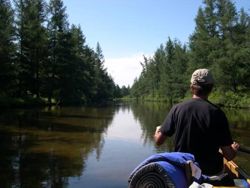
This part of the river turned out to be wonderful. The dam seemed to cleanse and rejuvenate the water. The river was shallow again, picked up speed and for several miles we enjoyed repeated riffles thru gorgeous scenery. We did however have to watch out for large rocks but they were fairly easy to spot by the water turbulence they created. Many of the river banks were high sand bluffs slowly being eaten away by the river current.
 At many points, here and all along the river, we came upon channel divides in the river where we had to decide which to take. The shortest route would generally win out but we occasionally got hung up in channels that were too shallow or blocked by debris.
We enjoyed the strong current until it petered out in the large pond that backs up behind Tippy Dam. As we traversed across the pond we could see that it was surrounded by numerous campsites. It appeared deeper and more boat friendly than the Hodenpyle pond. Actually its a beautiful body of water but Don and I were intent on getting to the second portage at the Tippy Dam and finding a campsite down river. We paddled hard into the wind for several miles and finally reached the portage.
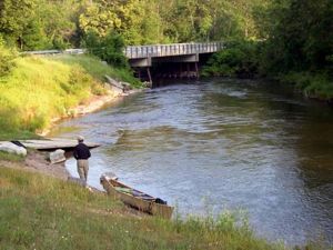
This portage was not like the first one. This one involved hauling everything about one hundred yards up a dirt road, then crossing a paved road and walking three hundred yards down a sweeping paved drive to the launch site. It was a real workout but the launch site was amazing. Sparkling water virtually shoots out of the dam and creates a newly energized river that rushes past the launch site and downriver. There were several fishermen on the banks or wading in the river near the boat launch.
This was one of the best legs of our paddle. The river bottom was gravel rather than sand and recurring pools seemed all to contain good sized trout. We were amazed by the number and size of the fish we were seeing. This continued throughout this days paddle. The scenery was spectacular and the river had more riffles than all the previous sections.
Several miles downriver we stopped for the night at primitive campsite on a twenty foot bluff overlooking a big sweeping bend in the river. This was probably our best primitive site because it provided a beautiful panoramic view of the river. And from the top of the bluff we could look down into the clear water and watch large fish linger along the river bottom.
We were also feeling content because we had covered enough distance to reach our final destination on the following day. The beans and rice tasted better than ever.
The next day we began the last leg. A few miles down river we stopped briefly at the Bear Creek access site. We told a local fellow about all the large fish we were seeing and he speculated that they were Skamaina, a type of salmon that runs in mid-summer rather than the fall. Maybe. This site is also where our river guide suggested ending the trip. The river below is described as wide and slowwater better suited to powerboats than canoes. Maybe, but we were going on.
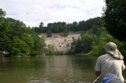
The river did slowly widen out and become shallow but the water remained fairly clear and the scenery continued to be attractive. This section also contained an increasing number of dead uprooted trees along its banks and bends. Another obstacle for paddlers was the growing number of large, barely-submerged sandbars that forced us to favor the outside flow of the river bends.
When we finally paddled into Manistee Lake we wondered why anyone would avoid this last section. It was picturesque and a worthy paddle. Contrary to the guide the river is not better suited to powerboats. We saw no powerboats and only a few might venture up this part of the river because it is generally too shallow and filled with sandbars.
On our paddle to the campground we ran into some trouble when we got too near the reed beds and into water too shallow for the boat. We were forced to get out of the boat and pulled it toward deeper water. Everything was fine until we encountered some muck and found that we couldnt move our feet. When we attempted to move we sank deeper and the muck began to suck off our shoes. After a moment of panic we got out by pulling our bodies into the canoe and using it as leverage to free one foot at a time.
It was great to reach the campground run by the City of East Lake. We had paddled 156 miles in six days. When we started we didnt know how long it would take us or whether we would run into difficulties that would require us to abandon the venture. Everything including the weather had cooperated and we felt that we had mastered our challenge.
That night we had a great steak at Ricos Bar and Restaurant on nearby M-55 and plotted our next day. We could call our trip a success and go home or we could finish two small bits that remained. One was the three miles across Manistee Lake and through the channel to the Manistee lighthouse on Lake Michigan. The other was the initial six mile section starting at Deward that we had skipped when we started. Without doing theses sections we could not say that we had paddled the entire navigable river to Lake Michigan. Well that settled that. We would spend another day.
The next morning, Sunday, we paddled across Manistee Lake and down the channel that runs through the City of Manistee out to the light house on Lake Michigan.
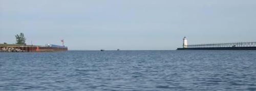
It was a beautiful morning. The church bells were ringing and some fishermen were out trolling for salmon (or anything, really). Large boats moored along the channel were only beginning to stir as we passed back and forth through the channel.
We then packed up and drove back to the Whispering Pines Resort. The Howletts were surprised but pleased to see us again. Mike Howlett drove us to Deward in Dons van and we tackled the six mile paddle back down to the resort.
This was a much different team than had started seven days ago. Then it had taken us 2 hours to go 8 miles from the resort to the M-72 Bridge. This first 6 mile section was even more difficult. I would describe it as being more like an Olympic obstacle course. But we did it in only 90 minutes.
When we reached the resort we packed up and were ready to leave when the Howletts invited us to a picnic table and served us raspberry shortcake with ice cream. That was a perfect conclusion to a great paddling adventure.
Outfitting:
Kevlar canoe
Fees:
No
Directions:
Michigan I-75 to exit 164 (Frederic), west 7 miles on Co. Rd.612 to the river and Whispering Pines Resort.
Resources:
The Whispering Pines Resort website: www.whisperingresort.com
Trip Details
- Trip Duration: Extended Trip
- Sport/Activity: Canoeing
- Skill Level: Intermediate
- Water Type: River/Creek (Up to Class II)