
Magalloway River in New Hampshire
Trip Overview
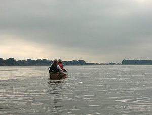
 Paddled approximately 7 miles on the Magalloway River starting at Wilson Mills and ending at the Umbagog National Wildlife Refuge canoe launch.
Wilson Mills has a nice launch will ample parking on river right. The refuge canoe launch is on route 16 with a paved parking area. There is another launch further south at the refuge office and parking across the street.
The current was quick in the early section of the paddle and slowed down about 1/2 way down river. Right after the put in there were two islands to go around.
Route 16 is nearby and the river comes close to it at one section. Even though the road is close, it is a nice paddle with views of some peaks. A covered bridge crosses the river.
On this second weekend in September, we encountered one group of students from Dartmouth College. About 5 miles down river there is a land grant owned by Dartmouth with an airstrip. The students were camping there.
 The Diamond River enters the Magalloway on river right at the end of the airstrip. We tried paddling up the Diamond River but there was not enough water. We had planned to do some exploring on the trails up the Diamond River, but the group just wanted to relax. We experienced about 5 small planes land at the airstrip.
The take out is in a backwater of the river on the right and there is a sign off the main river. We mostly floated down the river and you could easily do this section as a 1/2 day paddle.
There is a campsite, Diamond Peaks, on river left about a mile before the put in right before the Route 16 bridge. It has many grassy sites with an outhouse way in the back of the campground. There are only two sites by the water that are not very flat. The flat sites are further back. Reservations are required through Northern Waters/Sacobound.
Accommodations:
Mollidgewock State Park Campground - primative
Diamond Peaks river camping, accessible via river only
Fees:
To paddle river, no.Camping is approximately $10 a night
Directions:
Route 16 North from Errol, NHResources:
AMC River Guide - NH & MENorthern Waters/Sacobound Website
Trip Details
- Skill Level: Beginner
- Water Type: River/Creek (Up to Class II)