
Lumber River in North Carolina
Trip Overview
This was our tenth year for doing our annual "Dumb but Tough" trip and we decided to head back up to North Carolina after a break of going down to Georgia and South Carolina. We call these trips "dumb but tough" as we don't know exactly where we will camp or whether there are any trees down across the river, or even an accurate weather report, so if you're gonna but dumb you gotta be tough.
The trip this year was back on the Lumber River in NC which we did nine years ago. Here is the report from nine years ago:
Lumber River Extended Trip Report, Feb. 2004 although the last trip was the entire Lumber River about 135 miles, this year we decided to just go down to Fair Bluff, NC. Dates for the trip were March 1-7, 2013.
Friday � March 1
This writer (Don Meece) headed out of Salemburg, NC into Fayetteville, NC to pick up one of the trip members, Dave Bartlett. This was his day for retirement from the US Army. After picking up Dave, his canoe and gear, we headed down to the put in on the Lumber River at Turnpike Rd, in Scotland County, NC. This is section 1 in Paul Ferguson's book, "Paddling Eastern North Carolina".
Dave and I met Wayne Charles from Lexington, NC, (Wayne and I are two of the original dumb but tough members) we unloaded our boats and gear and Wayne and I headed down to the town of Fair Bluff, NC to leave the cars and meet our shuttle driver. Before leaving Fair Bluff, we visited the Lumber River Visitors Center, Gene Martin, and informed him of leaving two vehicles at the take out. He called the local police to inform them also. About an hour later we were back at the put in to start the trip.
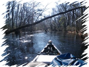
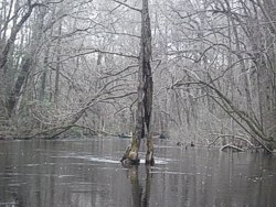
We got on the water around 1215 and headed down river. The water level was high, the reason we do these trips in the winter and current very good. After about 5.6 miles, we passed Lumber River State Park at Chalk Banks only open Thursday-Sunday due to staff shortage. After 5.9 miles we passed the Chalk Banks canoe in campsite and after 8.3 miles passed Hwy 401 north of Wagram, NC. We were now in section 2 of Ferguson's book. After 14.1 miles we reached our first night campsite, Jasper Memory Canoe in campsite maintained by Lumber River State Park, a nice high campground with a fire ring and picnic table. We set up our tents and Dave had a hammock with him. That night we grilled steak and pork chops.
 Saturday � March 2
Next morning we had a quick breakfast of honey bun, cinnamon buns, Dave had oatmeal, and coffee. We packed and headed back down the river by 0915. We had no problems or portages all the way to the next section 3 at McGirts Bridge Rd. We passed Hwy NC 71 Bridge above Maxton, NC, which is the beginning for section 4 in Ferguson's book, heading down the river and came upon our first major obstacle. A huge pine tree was across the river and we had to climb out on the tree and pull our three canoes loaded with gear over. This area is very swampy and we finally found a high place to camp with a road running into it. We had gone a total miles since beginning of 29.2 miles. (All mileage will be from the put in.) There were not any posted or no trespassing signs so we took a chance, although we do not like roads coming into a campsite.
After setting up tents and a hammock started the charcoal and had steaks and pork chops again. Temperatures at night were hovering around freezing but a campfire and good mummy bag helped.
Sunday � March 3
Another morning of a light breakfast of coffee and sweet rolls and Dave had his usual oatmeal. After packing we left around 0915. We passed several more bridges and had a few more trees to go across and after going a total of 46.6 miles we found a nice place in the woods on river right to camp. Grilled steaks again this night. We each carry a small bag of charcoal and grill out the first three nights.
 Monday � March 4
After breakfast of oatmeal and coffee we were off again around 0910. In section 7 between Three Bridge Road and Lowe Rd, Lumber River State Park has put in a new canoe in campsite, 4 miles below Three Bridge Rd, it is called John Culbreth Canoe In Campsite (coordinates are 34.62547 79.14243), a nice campsite but we were too early to camp there so we pushed on. Finally at 3:45 pm we were close to Lumberton, NC and I-95 and camped where we camped nine years ago at McMillan's Beach. It is owned by the town of Lumberton and the road is gated. It had a nice fire ring but after last time said I would never camp there again because of the traffic noise from I-95, well I lied so we set up camp after a total distance of 63.5 miles. We were in section 9 of Ferguson's book.
That night, Wayne volunteered to do the cooking and cooked up a great pot of red beans, rice, with summer sausage, really good. That night after a few phone calls, we heard through making a phone call, there might be bad weather moving in the next day or evening. We decided to get up early and try to get to another canoe in campsite with a shelter over the table.
Tuesday � March 5
After eating a light breakfast of coffee and honey bun, we were on the river by 0730, headed under I-95 and through the town of Lumberton on the river. We had several cut through because of high water and reached Matthews Bluff for lunch and after lunch put on our rain gear. This is the beginning of section 11, and Matthews Bluff has a really low bridge. We had to get low in the canoe to go underneath. We paddled on under light rain making it to Willoughby Rd, beginning of section 10, paddling on past a canoe-in campsite called Buck Landing and then another 2 miles we reached our destination at Piney Island, Lumber River State Park, canoe-in campsite. It is a nice site with picnic tables, fire ring, little pier and a big shelter so Dave could hang his hammock in. We had come a total distance of 85.3 miles since Friday.
The rain had stopped so Dave cooked shared dinner of taco soup and chicken, another delicious meal. After a phone call to my wife, she said the next day we would have wind gusting to 30-40 mph. We sat around the fire that night until the rains came and since it was late we all headed in the tents and hammock.
Wednesday � March 6
Next morning was nice but windy and I decided to cook side meat and eggs with green chili pepper and onions and the other ate their oatmeal. We packed in the wind and headed out. After a total of 89 miles we reached Hwy 74 at Boardman, NC and took a break out of the wind which blew our canoes around. Our goal was to reach the Lumber River State Park at Princess Anne, this section being section 13 in Ferguson's book.
After a short stop for lunch at a place called Upper Parkers Landing (93 miles), we made it to the park and got a canoe-in campsite after 97.6 miles at 2 pm. We were ready to get out of the wind. You have to pay for these sites and they are $13. We set up camp and later the Park Superintendent, a good friend, Neill Lee visited us.
That night was my turn to cook, and I fixed a pot of Mexican rice with venison summer sausage, it was equally good. That night was a little cold; we sat around the fire then hit the bed. When Dave set up his hammock this night he chose a small tree and in the morning was almost dragging the ground, so he got up around 0430 to start a fire.
 Thursday � March 6 � Our last day.
We got up early, had light breakfast of oatmeal and coffee and headed out at 0830 for our final destination, Fair Bluff, NC. As we paddled down a man came up river in a small motorboat. He said he had seen our cars for several days and wanted to come up river to check on us. We thanked him and told him the police knew we would be in at least by Friday and we were a day early. Near the town of Fair Bluff, NC we had a big short cut called Red Belly Slough and made to our take out at 1130. Total distance for this trip was 107.4 miles; keeping in mind we had short cuts because of high water.
It was a great trip, difficult for the first three or four days due to all the turns and obstacles and also cold weather. We saw a lot of wild life: deer, turkey, otter, beaver, owls, herons, osprey, other bird life and Dave spotted a water snake on a log trying to get warm. Dave was the rookie on this trip and joins, myself, Wayne, and two other individuals as an elite member of the "Dumb but Tough" group.
Note: The sections we paddled are best done at high water due to downfall. We used the USGS gauging station at Boardman, NC and water level down there was 6.60 ft.
Outfitting:
Old Town Penobscot Tandem, Old Town Camper, Old Town Solo Penobscot 15
Fees:
Lumber River Canoe-in campsite at Lumber River State Park, Princess Anne was the only fee at $13
Directions:
Put in on Turnpike Rd, NC State Road 1412, Scotland County about 6 miles East of US Hwy 15-501.
Take out was Fair Bluff, NC
Resources:
NC Delorme Atlas and "Paddling Eastern North Carolina with Paul Ferguson" book
Trip Details
- Sport/Activity: Canoeing
- Skill Level: Intermediate
- Water Type: River/Creek (Up to Class II)