
Llano River in Texas
Trip Overview
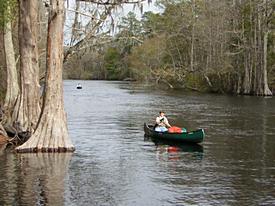
Canoed the entire length of the Llano River in the Texas hill country. My brother Daryl was with me the first 55 miles, after that just me. Its 105 miles from the put in at Junction, TX to the take out at the "kingsland slab", near Kingsland, TX. This river is formed by the junction of the North and South Forks of the Llano River. It is a typical hill country steam of the pool and drop variety. Most of the rapids are class I-II, the difficulty going up with the water level.
Most of the river is rarely paddled because it has a wide, shallow, rocky bed which means there can be a lot of canoe dragging. Fortunately this has been a record year for rain in the hill country, so I thought- why not?
The first 20 mile section is from Junction to Yates Crossing (Ranch Road 385). This section is the only part of this river mentioned in the book "Texas Rivers and Rapids". It is the most canoe friendly part of the river, nearly always navigable. The large limestone hills, bluffs and ridges of the Blue Mt. range come right to the rivers edge. Lots of deer and turkey. Great fishing. There was a rapid on the average about every 3/4 mile, mostly rock gardens and some ledges, including Nethery falls at the 4 1/2 mile mark. It's a ledge with a 3 ft. horseshoe drop in the middle. We camped 2 nights on this stretch at Llano River Camping.
The next 20 mile stretch was Yates to Whites Crossing. This stretch is rarely run because it is so shallow and rocky. The rocks are fluted wagon track limestone. We heard horror stories about this stretch. The rocks are punctuated by deep holes. You can hang on a rock get out to drag it 10 feet, come to a 10 ft. deep hole, get back in paddle 10 feet, hang up again. Repeat for abut 14 miles Folks have abandoned their canoes in the middle of this stretch and hiked out to the road. As a matter of fact, we did find an abandoned Coleman at mile 14. This bad section started at mile 7 of this particular stretch. Fortunately for us, there was just barely enough water at 145 cfs to float our loaded down canoes over most of the bad spots. The scenery was even better than the first stretch. We camped 2 nights on this stretch, on gravel bars.
The next section was from Whites Crossing to the Hwy. 87 crossing, a distance of 16 miles. The shallow wagon track limestone eased up about an 1/8 mile after Whites Crossing. About a 1/4 miles downstream there is a tough little rapid around a bend with a house size rock on the right that I hit, twirled backwards onto a ledge drop, the canoe hangs there, starts to turn sideways and tips with all my gear, I jump out, drag the heavy mutha off the ledge, jump in before it gets away, fall backwards with one leg hanging out, exit rapid into tree, right myself, got loose from the tree, paddle to sandbar. Not pretty but I made it without tipping. My wise brother lined his through.
A mile later a nearly identical rapid, only bigger. This is a named rapid: "Simmons Hole." Once again I head right for the rock, but this time the current carries me right by it, over the ledge drop and out into the main channel. A perfect run, thanks to the current. This is a very scenic stretch, lots of big hills and high red sandstone bluffs.
At mile 4 is the James River crossing. The river splits around a large island that the locals use as a swimming, camping, off-roading, party spot. We take the left channel. I go under the road in my canoe and am lucky not to hit the concrete that divides the tunnel. Daryl wisely walks his under the road. Just downstream Todd Creek comes in on river right with very scenic limestone overhangs and small caves in a limestone bluff. The river has some wide long quiet stretches the next couple of miles, with occasional class Is.
 About 3 miles downstream of James Crossing is Martins Bluffs. Ive been told they are 200-250 ft. high. Across from the bluffs are beautiful white and level gravel bars. This is probably the best camping spot on the Llano River. But it was too early in the day to camp.
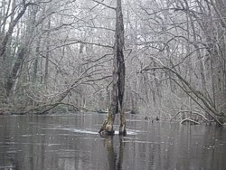
We continue down to Martins crossing. Portage right, a tough, steep, portage with some barbwire to boot. Made camp downstream on river right. Dove hunters were finishing up across the river. They are back at it next morning as we head towards the Hwy 87 crossing, my brothers takeout. The river has changed from limestone to granite. Big granite blobs start to appear in the river and coming out from the banks. They are gray, the pink ones will be further downstream.
The last mile or so before the 87 bridge is one long boulder garden with a myriad of channels to choose from with drops, twists and turns. Daryl takes out at Llano River RV park (top notch) where his truck was parked. It was noon. I hung around about an hour to help him load his canoe and gear, then headed to Castelle. The river gauge here read 703 cfs. Last year at this time it was about 90 cfs on this section.
The 11-mile section between Hwy 87 and Liefeste campground in Castelle alternated between short wide pools and granite boulder gardens that would fragment the river into many channels with ledge drops at the end of the boulder garden. I capsized on one class I and had to pull ashore, spread my gear out to dry, then repack. I lost a rod and reel and a cap that wasnt tied down. You dont see as many hills and bluffs, but there are some high banks and granite outcroppings on the banks that are up to 30 ft. high. Also a lot of houses on this stretch, mostly old farmhouses with windmills, and some more modern guest cabins and lodges. On this stretch the gravel bars are turning into sand bars, with deep loose sand. About halfway through this section is an old mill wheel at a ledge drop. Ran it on the left.
I stayed at Liefeste campground for 2 nights, and took a day of rest. Then I headed towards the town of Llano, 18 miles downstream. I waded under the Castell Crossing, then it was 5 miles to Schneider Crossing. About a mile before Schneiders crossing is Hoffman Falls. It was pretty easy. I had passed through many no-name rapids on this trip that were more exciting. As a matter of fact I tipped over on one a couple miles past this crossing! I knew the drill. Swim canoe to shore, tip it over to drain, unpack gear, spread out to dry, repack gear, continue downstream.
5 miles from Schneiders Crossing is Scotts Crossing. I camped on a sandbar downstream. This stretch had been one boulder garden after another. The granite is every where on the banks and in the river. Big slabs, house sized boulders, ledges and drops. Every boulder garden signifies a drop in the river gradient, and there are some nice rapids at the the ends of the gardens. Even in the quiet pools the are big blobs of bubblegum pink granite in the blue water that reflect the blue sky with the puffy white clouds. Very surreal. Somewhere along this stretch was another mill wheel, on river right, right before a small perfectly straight ledge drop.
Now I was 6 miles from Llano, and 26 miles from the end of the trip. There were 4 more big drops through boulder gardens before I hit a long deep pool backed up by a dam at Robinson Park. I portaged river right, then another mile through flat water to the dam under the Hwy 16/71 bridge at Llano. I got a burger and jug of water in town, then portaged river left.
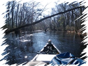
This next stretch I had measured at 20 miles, but it may have been more like 16. I got about 8 miles downstream of the dam before I stopped to camp. This stretch of the river is hardly ever run - too shallow and rocky. The bed is full of granite rocks and boulders of all shapes and sizes. My only hope was that there was enough water to get me through without too much dragging and scraping. Lucky for me, the Llano gauge was at about 500 cfs. Usually this time of year it's about 80 cfs. Even at that, there were many places where I barely skimmed over the sandy bottoms in the pools between the boulder gardens. Then in the boulder gardens, I had to get out frequently, push off of or drag over a rock, hop back in the canoe for a short length, the get out and drag, pull or push the canoe again. Short pool, long boulder garden, long pool, short boulder garden.
 As I pushed downstream, the pools got shorter and the boulder gardens longer. There was a lot of gradient to these gardens, with some impressive ledge drops at the end of them. This stretch of river was very beautiful. The mountains and ridges were back in sight. For much of the way, a railroad paralleled the river, and incoming creeks had scenic trestles spanning them. There is a bald eagles roost on this section. Theyll not be back until winter, but I did see a huge osprey. The sandbars have a very fine and hardpacked sand. Great to sleep on and will hold a tent stake. There are 2 road crossings close together at about mile 8. Actually I think they are low water driveway crossings for a private ranch thats on both sides of the river. I camped at about mile 9,
The next morning was the last day of the trip. More boulder gardens. At about mile 15 downstream of Llano, I came around a bend at the start of a rock garden and saw a trailer on river left, and a bunch of picnic tables and meter poles. This was Longs fish camp, and I knew my takeout was only a couple of miles down stream. About a mile downsteam was Longs Falls, my last obstacle. I paddled into the rock garden as close to the roar of the falls as I dared, pulled up to river left, got out and tried to check out the falls. Couldnt get close enough to see em. I almost went ahead and ran them.
Instead I went back upstream and crossed over to the right bank. On the right bank was a huge pink granite outcropping about 60 ft. high against a backdrop of a mountain and the river downstream. Amazing scenery. I climbed this outcropping and got a good luck at the falls. They were awesome. A long drop into a big hole and backwave leading into another drop with a big hole and backwave.
White foamy frothing crashing whitewater that a whitewater kayaker would drool over. It scared the bejeebers out of me to think that I had nearly run it in my open canoe loaded down with gear. I bet its a class IV. The Llano gauge was 783 cfs. Off to my right was a small channel that entered the river just down from the falls. So I was actually on an island. I portaged over to that channel, got back to the main river, went around a bend and was at the head of the Kingsland slab. I had to pick my way through and over the slab about a half mile to the road crossing. Then I unloaded my beloved canoe, took my gear to the road, went back and carried the canoe to the road and called my shuttle. I was wore out.
At the start of the trip we camped at Llano River Camping. They shuttled us to the put in at Junction, and we canoed 12 miles back to the camp. From there we loaded up our canoes and camped on gravel bars and islands until Hwy 87. Tony Plutino of Mason, TX and Frank Falk of Castell, TX helped us with our take outs. They are top notch.
Outfitting:
Oldtown Discovery 133
Oldtown Guide 147
Fees:
You pay for shuttles and camp sites
Directions:
From Dallas- US 67 South to Stephenville, then US 377 South to Kimble County Rd. 314. Left 1.3 mile to gate
Contact:
Will Murrah: Campground and shuttle at Llano River Camping
Tony Plutino: shuttle
Frank Falk: shuttle and campground Liefeste Campground
Resources:
"Texas Rivers and Rapids" by Bob Nolan & Bob Narramore
"Texas Whitewater" by Steve Daniel
southwestpaddler.com by Marc McCord
paddling.com
Topozone
Google Maps
Trip Details
- Trip Duration: Extended Trip
- Sport/Activity: Canoeing
- Skill Level: Intermediate
- Water Type: River/Creek (Up to Class II)