
Lake Erie Islands in Ohio
Trip Overview
As the hurricane force winds and the driving rain pounded the strained sides of my three season tent, I lay spread-eagle in my tent praying that gravity would work in my favor and not lift me into the trees that lined our campsite. And so began the third annual South Bass Island Kayak Rendezvous on June 8-10, 2007. This review will outline how 20 minutes of savage rain, didnt put a damper on another successful gathering at South Bass Island.
Actually, my rendezvous began earlier in the day on June 8 as my friend Jay and I suited up and left from my parents beach on the outskirts of Port Clinton, OH. This launch point usually adds about 6 miles of warm-up paddling as we paddle across the Catawba Island peninsula and out to our usual regrouping point east of the Miller Ferry near the tip of the peninsula. We had not made plans to rendezvous with any additional paddlers this year, but I wanted to take a peak to see if anyone was suiting up for the crossing to South Bass. Paddling to the beach we saw two kayakers readying their boats for launch. The paddlers ended up being past attendees of the rendezvous and familiar faces. As we stood on the beach, several additional paddlers either drove by on their way to the ferry or stopped to say hello before dropping their gear for launch.
After a brief rest and regrouping the four of us launched for the three mile crossing to South Bass Island. High winds and an impending thundershower provided a sense of immediacy as we made a bee-line due north for the island. Winds were speeding out of the west and a dark horizon foreshadowed the incoming shower. We figured we had about three hours to make the crossing, set-up camp and batten down the hatches.
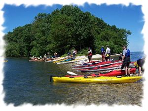
Other than adjusting for the 15 knot and increasing winds, we made a speedy crossing and rounded the tip of South Bass Island near its lighthouse and headed for the State Park. We beached our boats and didnt waste time checking-in and hauling gear to our cliff top campsites. I was happy to see many regulars already set-up and readying their campsites. We were hoping for a large turnout for this years rendezvous and from the looks of the boats and campers, kayakers would be in the majority this weekend. Eddyline Steve, Sharon from Lansing, Kathy and her friend Amy from Detroit and a host of past and new kayakers were already on the island to greet us.
Jay and I cooked a quick meal, sat at our campsite and watched the whitecaps as they began to pound the beach. I remember wringing out my shirt as the first lightning bolt struck in the distance. We were glad to be off the water and as the waves increased in size and the white caps started to roll further and further in the distance. Ive never wished to visit Hell, but if it looks anything like this storm, Ill make every attempt to meet St. Peter instead. Lake Erie is known for its powerful and fast approaching storms and this one was playing true to form. A shared set of binoculars pointed out two kayakers in the distance only one step ahead of the blackness. With shock and amazement we cheered and nervously waited for the two bodies that were a good distance offshore in open water. In a flurry of arms, paddles and whitecaps, the two paddlers closed the distance from their position to the beach in a matter of minutes and were approximately five paddle strokes ahead of a wall of rain you could bounce a ball against. In one motion the two paddlers skidded several feet up on the beach and safely jumped out of their boats just as the following whitecaps pounded at their heals. With adrenaline pumping and their chests beating, past attendee Kelly and a new arrival Lee described how they rode over on the ferry, but wanted to paddle to the State Park. They had swung way out to the west of the island to take advantage of the following seas to surf into camp.
Before Kelly and Lee could catch their breath, stabbing pebbles of rain and sky the color of graphite knocked on the door of our campsites and we quickly realized we were directly in the eye of the storm. A mad rush to secure tents, boats and gear helped to distract our crew as the teeth of the storm began to bite down on the island. Without the luxury of radar or the internet, we had no idea how long wed have to hunker down in our tents as the storm passed. After checking on several members of our group, I dashed to my tent and made a diving leap for semi-dry shelter and a good book. I looked at my cell phone and noticed a text message from Findlay Joe, a regular that had to stay home this year. His message said hold on, youre going to get pounded. He also wanted to know what we were up to and I typed back sitting in my tent praying.
Almost as quickly as the storm pounced upon us, it blew through and passed over the island like a car passing through a motorized car wash. Like newly formed butterflies emerging from cocoons, the distinctive sound of zippers started to echo along the cliffs. Familiar sounds of bodies stretching and exhales of tightness retorted along our row of tents as the sun unexpectedly blazed through the rapidly parting clouds. In twenty minutes, I witnessed an amazing amount of water fall from the sky in a surprisingly short amount of time.
Round one for the evening had passed with relatively little damage, but at least one tent was uprooted and rolled through camp. Just before the storm another paddler had ridden the Miller Ferry across, but had launched for the short trip to the beach at the State Park. In all the pre-storm commotion, we had watched the paddler pass in front of the park and disappear around the bend to the north. After the kayaker didnt re-appear before or after the storm, a ranger was flagged and the search began. Within 20 minutes, the paddler was spotted standing, dripping wet under a tree near downtown with paddle and gear. He had missed the beach, tents and boats lined on shore and continued around the north side of the island in search of the State Park. Once he reached downtown Put-in-Bay he must have realized that he should have taken that turn at Albuquerque. The paddler was quickly retrieved and reunited with his traveling companion from Cincinnati.
With bodies, gear and tents re-secured, the sun was now in full bloom, many hands pitched in to assemble our base-camp meeting area for the weekend. A large tent was erected for our first ever pot-luck dinner. Our official rendezvous banner was hung and the dinner bell sounded. All attendees were invited and mounds of food were presented for consumption. As our group gathered, socialized and ate, we welcomed everyone to the island for the third year and ran through the basic outline for the weekend. We also took roll call and found that we had kayakers from many every major city and a few minor cities in Ohio, a cast of characters from as far away as Traverse City, Detroit, and Lansing Michigan and as well as other parts of Michigan. We also had a couple from Indianapolis that had read about the Rendezvous on paddling.com and a paddler from Kentucky by way of Toledo. Each year the scope of attendees continues to grow.
Another new item for this years outing was the design of a logo and the creation of t-shirts. Shirts were distributed and quickly hailed as collectors items! As the evening continued, car-after-car with kayaks in tow kept arriving from the ferry. As dusk started to settle a small group of us wanted to try a night paddle. Five of us geared up, donned our headlamps and taped glow sticks to our paddles. The water was still a bit rough as we launched into dark water and amber skies. We paddled the mile long shore to the Put-in-Bay lighthouse and back to the beach. Jay and I decided to extend our paddle and headed north towards Green Island. We stopped in the shadow of South Bass Island and watched with childlike amusement as dozens of sailboats rounded Green Island as part of the Annual Mills Trophy Sail Boat Race. Jay and I bobbed in the water and smiled at each other. Without saying a word, we knew that neither one of us wanted to be anyplace else but in our kayaks watching sailboats speed by under dusk heavy skies. In the dark we were close enough to hear captains calling out commands and winches cranking beneath wind strained sails. Good wind from the storm was pulling the boats along at a good clip, but the sailors still had a long night of sailing ahead of them. As wild as day one began, its ending was relatively mild as a group of us closed the evening with cocktails, cigars and a campfire.
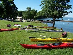
 On day two, more than 50 paddlers started making their way to the beach for our 10 a.m. group launch. The weather was perfect for paddling, sunny, but refreshingly cool, waves were mild and the wind wouldnt be an issue. Like the previous two years, I hung back and watched with giddy amazement as 50 sets of kayak blades in every shape and size dipped into the water. The plan for the morning was to paddle to the Put-in-Bay harbor, regroup, paddle to a lunch spot on Sugar Island and then split into two groups for an afternoon of paddling. After leaving Sugar Island, one group would continue around North Bass Island and a second group would head south and around Middle Bass Island. It must have been quite a sight from shore as our rainbow armada cruised in front of the cottages along the island. I noticed more than a few observers emerge from their homes with cameras in hand.
After a quick stop in the harbor, we headed for Sugar Island and lunch. This year our larger party took up pretty much every square inch of our rocky landing spot. In years past we could land below the waterline on the rocky sand bar that stretched south towards Middle Bass Island and enjoy a quick lunch. Higher water levels reduced the area we could land and it didnt take long before one of the islands few inhabitants realized they had visitors. We were pretty much loaded and launched by the time word went out that we needed to vacate. In the future we agreed that wed head right for Manila Bay on the north side of North Bass Island for our annual lunch. On North Bass Island, theres plenty of shoreline, the island is pretty much uninhabited and owned by the State of Ohio. As we left Sugar Island, we waved goodbye to the Middle Bass party and turned our boats north.
I was with the group that went to North Bass. I had traveled out there for the first time last year and was enamored with the extremely clear water and the totally white shell beach of Manila Bay. I also knew there was an inland lake near the northern edge of the island and accessed from the bay. I had seen aerial photos of the island and wanted to see if I could bushwhack my way inland and explore. As we rounded the island clockwise and into Manila Bay, we were not disappointed, the water was just as clear, calm and warm as it had been last year. It was a good spot for a dip or to practice a roll or two. I scanned the shoreline for any inlet that looked like it connected to the inland lake. Towards the eastern end of the bay I spotted a little cut-in that looked like it could connect. I couldnt paddle up the cut-in due to the mounds and mounds of zebra mussel shells, but I exited my boat and hiked up a tiny creek-like waterway into muck up to my knees. Craning my neck, I could see though the jungle-like reeds and could tell there was definitely something back there! I called out to my buddy Jay, whose boat was smaller than mine. We carried his boat over the shells and launched him into the undergrowth. Jay was swallowed by jungle foliage in a matter of seconds. After Jay didnt immediately return, I figured he found something or was eaten alive by some near extinct giant lake reptile. Jay soon returned and reported that there was a navigatable lake behind the 10 ft. tall reeds and undergrowth. With my interest even more peeked, I talked Kathy into joining us on our expedition party. Bending low, we picked our way through the only kayak-wide access channel to the lake. Once we emerged through the reeds, we found what looked like a 2-3 acre lake. Cattails and reeds were starting to choke off the lake and in my guestimation, it will cease to exist in five years. The three of us paddled the length of the lake and explored the lily pad covered coves and cut-ins. As we exited the lake we had to again bend low in our boats to sneak through the outlet and back to Manila Bay. Where the waterway ended we had to carry our boats over the mussel shell break water and launch into the bay. Jay and I practiced a couple of rolls to wash some of the muck off our bodies and boats. The rest of our group had gone ahead while we explored and our larger party was now a party of three. We quickly made up time and caught our group as they were finishing a rest stop on the southern side of North Bass Island.
With good weather ahead of us, we plotted a course for Rattlesnake Island. We had cut around Rattle snake last year, but I wanted to actually circumnavigate the island this year. Theres always been mystery surrounding the island. For years Ive heard stories about mob ties to the island and gun wielding security guards and trained Dobermans. While all of these rumors are unsubstantiated, the island is still off-limits to non residents and privacy is strongly enforced. We finished the 4 mile open water paddle to the north east shore of Rattlesnake and continued to round it clockwise. Like most of the Bass Islands Rattlesnake has steep cliffs and interesting shoreline. In several places we could paddle between large chunks of island that have broken from the larger mass and settled close to shore.
After our full circumnavigation, the sun and a full day of paddling started to take its toll and we set a course for the 3 mile crossing back to South Bass for food and dry clothes. As we passed in front of the campground cliffs, cheers arose from fellow paddlers who had landed earlier in the day. We landed, stowed our gear and headed to the showers for a well deserved scrubbing. As in the past we gathered as many paddlers as we could and walked into town for cold beverages and food. As usual our path led us directly to the newly renovated Boardwalk restaurant. Our party quickly pounced on three tables of food, beer and appetizers. Downtown had its usual buzz from the hundreds of sailors that had landed from their all night race. By evening they had regained their second wind and were starting to crank up the party meter. It was fun to feel the energy of the island and look out on the Harbor to see hundreds of sailboat masts and the colorful yacht club and boat class finishing flags. Boats were moored four deep in the harbor and every mooring ball was attached to a fancy racing machine. A cruise through downtown and a leisurely walk back to the campsite found us again by the campfire with cocktails in hand and more than enough conversation to last all night.
 Day three brought another set of new additions to the rendezvous. During our planning, Mark Pecot, co-owner of 41 North, a Cleveland area outfitter and instructor offered to teach a full day of classes. Various paddlers had registered for a rolling class or an advanced rescue skills class. I think attendees were excited for the opportunity to increase their knowledge, because nobody is teaching kayak classes in the northwest Ohio area. I hadnt signed up for a class this year, because Jay and I had already made plans to paddle to breakfast Sunday morning and continue adding too our weekend mileage. Jay and I were joined on our breakfast crusade to Frostys Bar by a couple of paddlers from Cincinnati and following our meal we had arranged to meet another party to circumnavigate South Bass Island. It had been a few years since I had circumnavigated our home island, so I was excited to revisit this trip.
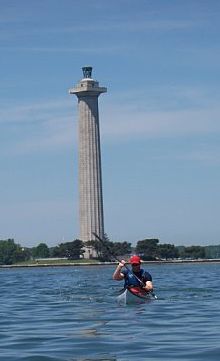
We had timed our finish just right to meet up with Eddyline Steve and our pre-arranged group for our trip around the island. Before we left I made a t-shirt delivery to Vicky Wiggle over at Kayak the Bay, a kayak rental business on the island. Upon regrouping we started out of the harbor towards Perrys International Peace Monument and clockwise around the island. We took our time and enjoyed a leisurely group paddle around the south side of the island. Jay and I stopped in the shadow of the monument to practice a roll and an assisted re-entry rescue. In an amazing demonstration of endurance and perseverance, Jay was able to roll, exit, re-enter his boat underwater, perform an assisted rescue and roll, which he proceeded to continue rolling back over by accident and then finally orientating himself enough to perform a final and successful assisted rescue. It was like watching a washing machine tumble around and around. We rejoined our group wet and happy for the final push back to the State Park.
By the time we reached the take-out beach, the afternoon class was heading out for their rescue skills class and we headed back to our campground for lunch and packing for home. Apparently the afternoon class received quite a scare as a pleasure boat careened out of control and headed directly for the class which was close to shore practicing. The group leaders are still unsure if the driver wasnt paying attention, drunk, irresponsible or all of the above. In a mad dash and flash of paddles and boats everyone was able to safely maneuver out of the way of the boat and in typical fashion the boat never slowed or showed any concern. Word from the class was that the encounter was only feet from being disastrous and nearly plowing through the large class of 10+ boats. The group reported that in the race to escape danger, one boat had t-boned another and punctured a hole in its hull. The class instructors signaled the Coast Guard and reported the incident. With everyone safe, they regrouped and were able to finish the class and tragedy was adverted.
Jay and I packed for home, said goodbyes to the few paddlers left on the beach and pointed our kayaks towards Port Clinton. The waves were below one foot and the wind was non-existent. Instead of heading for Catawba Point and along the northern shore of Catawba Island, we arrowed our boats in a bee-line directly for Port Clinton. We were going to attempt a beach-to-beach, 10 mile, open water crossing back to my parents landing point. Without having to correct for wind and waves, we were able to keep right on our target plot and without incident traversed over some of the flattest, glassy water Ive ever paddled. The only wave action we encountered was from passing boats and pleasure craft. Not even jet skis travel that far out in the lake. After and hour and forty plus minutes we landed safely at our targeted location and with little fanfare ended our rendezvous weekend. After checking our maps, we had paddled a little more than 40 miles of water in our weekend and were entertained by the many personalities and paddlers who joined us on the island. The little rain shower we encountered on the first day did not put a damper on our weekend and Id deem the 3rd Annual South Bass Kayak Rendezvous a marvelous success and I cant wait to return next year.
Accommodations:
The South Bass Island State Park houses fine facilities. The sites are clean, the tent sites overlook Lake Erie and the showers/rest rooms are well maintained. The park is still suffering from poor well water. Reservations can be made online at www.ohio.reserveworld.com or through www.ohiodnr.com.
Weekend campers are required to book a minimum of two nights and the cost in 2007 was $58. Sites book quickly, especially in the summer.
Outfitting:
Sea Kayaks, typical navigation equipment, charts, compass, GPS
Fees:
Ohio boat tags and payment for your campsite.
Directions:
Getting to the Port Clinton, OH area or the Erie Islands is easy. Both can be found by traveling east or west on Either Route 2 or the Ohio turnpike. Getting to South Bass Island can be done by taking the Miller Ferry or paddling to the island.
Contact:
This report covers the Third Annual South Bass Kayak Rendezvous which is scheduled each year on the second weekend in June. The weekend also coincides with the annual Mills Tophy Sailboat Race.
Our 2008 date is June 13-15, 2008. See the message boards on paddling.com for updates after the first of the year.
Resources:
Lake Erie Navigational charts.
There is also a neat website to consult for aerial photos and history of the Erie Islands: www.middlebass.org/index.shtml
Trip Details
- Trip Duration: Extended Trip
- Sport/Activity: Kayaking
- Skill Level: Intermediate
- Water Type: Flat/Sheltered Water