
Lake Buchanan and Lake Travis in Texas
Trip Overview
Paddlers: Ken Johnson, Mark Arnold, and Steve Frick
 Lake Buchanan, about 90 miles NW of Austin, TX, is the beginning of a chain of lakes in the Texas Hill country which are all connected by the Little Colorado River and eventually run into Town Lake in Austin: Lake Buchanan, Inks Lake, Lake Lyndon B. Johnson, Lake Marble Falls, Lake Travis, Lake Austin, and finally Town Lake right in downtown Austin. Lake Buchanan provides the most true wilderness paddling with many spectacular canyon cliffs of limestone and granite, waterfalls, springs, caves, Live Oak and Juniper wooded hillsides, and abundant wildlife. We covered the northern portions of Lake Buchanan and Lake Travis on this short trip.
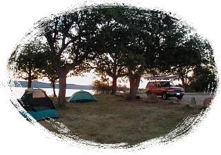
Monday 11/5: Mark and I left Corpus Christi at 10:30am Monday, driving to Lake Buchanan via Austin to stop at Austin Outdoor Gear and Guidance to pick up a new Performa kayak. We arrived at our secluded campsite (Cedar Point Recreation Area) on the northwest shore of the Lake by 4:30pm. Just time to set up camp, eat dinner, and get ready to paddle early the next morning. Was cool, clear and dry that night (40's) so I could sleep under the stars without condensation in the morning. Fantastic almost-full moon rose over the lake that night.
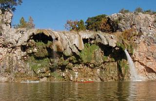 Tuesday 11/6: At 7:30am that morning we were joined by Steve Frick who although lives In Lago Vista on Lake Travis, had never paddled Lake Buchanan. We launched from the boat launch at Cedar Point (30deg52.13N, 98deg27.10W) at 8:30am on a clear sunny calm day. Paddled north (357deg) for 3.63 miles to the first water fall on the left (west) shore of the Little Colorado River. Although we've had little rain, there was a substantial flow of water over the falls falling about 50 feet into the river. We then paddled up river another 3 miles to the creek on the right (east) shore leading to the next waterfall. There is a large partly submerged log at the creek entrance and the falls are a short distance on the left at the end of the creek. The falls are much shorter, but wider, and there was little water flowing when we were there. There is a third water fall about another two miles up the Little Colorado River, but we opted instead to have lunch along the bank and then paddle back to camp heading into a brisk southerly wind. Covered about 14 miles round trip, returning to camp by 1:30pm. Early dinner, early to bed, and another beautiful night under the stars and moon. This area is where the Bald Eagles come each winter...usually after Thanksgiving. We didn't see any; only a few ospreys and lots of vultures.
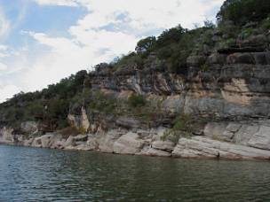 Wednesday 11/7: Broke camp about 9:00am and drove down river past Inks Lake, Lake Lyndon B. Johnson, and Lake Marble Falls, camping at the Camp Creek Recreation Area on a high hill overlooking north Lake Travis, just below the Max Starckle Dam east of Marble Falls. Set up camp and paddled about 7 miles south on Lake Travis past Double Horn Creek, Shaffer Bend Recreation Area, and Narrows Recreation Area. Found a great variety of landscapes: large homes hidden in the woods, large ranches with cattle, and at the end of the trip more limestone and granite cliffs and caves. Black, brown and red colors were reminiscent of Michigan's Pictured Rocks National Seashore by Grand Marais. Saw more ospreys and large communities of vultures on the beaches. Beautiful campsite and sunset overlooking the lake that night.
Thursday 11/8: Broke camp, and paddled west up to the dam, east retracing our Wednesday paddle to take more pictures. Had great weather for the entire trip, saw few other boaters, and enjoyed the peace and quiet the area offers. Both camp sites were free; Cedar Point offering a very clean restroom, Camp Creek with picnic table and fire ring, no restroom but only an 8 mile drive from the town of Marble Falls.
For more pictures please see: http://community.webshots.com/user/johnsonkw1>
Outfitting:
Austin Outdoor Gear & Guidance, Austin, TX 512-473-2644 Rents and sells all canoe, kayaking, and camping gear.
Kayaks: Mayan Seas 16' Performa fiberglass kayak, Mariner 15' Elan fiberglass kayak, and Old Town Millennium 17'4" poly kayak.
Directions:
How to Get There: From Austin, take 35N, 29W through Burnet, 261N to Bluffton, then 2241N and 3014E to Cedar Point Recreation Area.
Resources:
"Highland Lakes Camping and Boating Guide" by LCRA (Lower Colorado River Authority), free by contacting them at 1-800-776-5272
Trip Details
- Sport/Activity: Kayaking
- Skill Level: Beginner
- Water Type: Flat/Sheltered Water