
Kootenai River in Idaho
Trip Overview
 THE RIVER LESS TRAVELED
So I dont know? One day a year or so ago I had this notion that I wanted to trailer our boat; an 18 open bow ski/fish type boat to Bonners Ferry. Put her in the Kootenai River and drive all the way to Nelson British Columbia! You could do that! Cant you? I thought! So I found a good map and began looking at the route I would take. As I scanned the map I noticed that the river didnt just start at Bonners Ferry it came from the east and from Canada! Straight into a man made lake called Koocanusa, which is held back by the huge Libby dam before reforming as Kootenai River above Libby, Montana. The Kootenai flows swift and hard through the Cabinet Mountains and about thirty miles from the dam, it plunges over Kootenai falls. I thought to myself, how about a kayak? Could I put in below the falls and paddle all the way to Nelson?
I started my quest for more information and the right type of kayak I needed to make this trip. I finally decided what I needed with the help of the friendly people at Outdoor Experience a local kayaking, backpacking, xc-skiing, everything you wanted to know about the outdoors kind of place in Sandpoint, Idaho. I chose a 17 Perception Eclipse with plenty of storage space for all the gear and supplies I would need and a rudder for better control. I began by going out on Lake Pend Oreille to practice paddling, self rescue, and just basically having fun. One day I noticed the sail boats out on the lake and thought why cant I rig a sail for this Kayak? The very next day I began gathering parts from here and there that I thought I would need to make it work, an old tent pole, some extra fittings, a blue tarp, and the rest I bought at our local boat shop. With trial and error I finally got it figured out. My wife sewed the edges of the tarp to keep it from ripping and I added a few grommets where I needed them. Voila! I had the rudimentary beginnings of a sail. Later I even had my wife make a spinnaker!
As the winter months passed, I planned on a late spring departure, which turned into summer, then mid-September. I had hoped for the higher spring run off to help me along, but I would have to settle on what ever nature and the U.S. Corps of Engineers provided. The water flows were at 14,000 Cubic Feet per second (cfs) which I thought was pretty good. The river flows could be as high as 25,000 cfs or as low as 4,000 cfs.
I decided to leave from Troy, Montana below the Kootenai Falls giving myself a week to accomplish my goal. I gathered everything I would need; tent, sleeping bag & pad, cook gear, extra paddles, dry bags stuffed with food and the essentials. I had even purchased a backpacking size French Press for my morning coffee and a water purifier for clean water.
On Monday, September 13th my friend and neighbor Lou drove with me and all my gear to boat launch site in Troy, Montana. It was ten a.m., as I got ready I could see the river was running fast, it looked so awesome and powerful, I could hardly wait! I pushed off, said my goodbyes to Lou and headed off into the swift current. About two minutes later I hit the first rapids and after two or three waves of water crashed over my cowling and into the cockpit soaking me I thought it might be a good idea to put on the Kilt that would prevent that from happening again!
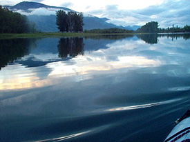
 As I headed down the river checking my GPS I was astounded that in some of the faster rapids I was making eleven and a half miles an hour! Wow, Ive never gone that fast in this kayak even with the sail in high winds and me paddling to boot! The river flows were in most places about five to seven miles an hour. It was fun watching the rocks under the water flash by me as I wound my way down the river.
My first major obstacle was the confluence of the Yaak River into the Kootenai. I had read that the safest way to negotiate these rapids was to stay as far to the right as I could, avoiding a dangerous current which would have slammed me into a wall of rock had I missed it. Other than that the trip was very beautiful as I floated by I passed a dilapidated bridge at the old abandoned town of Leonia and farther down the river I paddled by the mouth of the Moyie river.
As I paddled I saw Ospreys and Bald Eagles perched on the sides of the river and many large unknown fish I thought must be some kind of suckers in the shallows, although Ive heard there are huge Sturgeon in this river! I saw a family of river otters on the bank eating a fish.
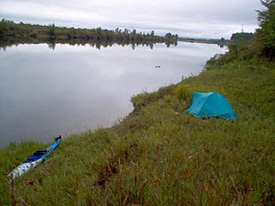
I crossed under the I-95 Bridge at Bonners Ferry at 4:30 pm and kept on going. The river from Bonners ferry area and down stream has man made dikes along both sides, built to keep the river on course during heavy spring runoff. These dikes make it very hard to find a suitable place to camp let alone just getting out of the kayak! Around 7 p.m. I finally found a great spot to camp about eight miles from the Bonners Ferry Bridge. It was at the head of a large island in the river, which had been grazed on by cattle, so the grass wasnt too high. It rained on and off that night and I finally made a break for it when the rain quit for awhile the next morning.
The second day I made it within about three miles of the U.S./Canadian border, and camped at the mouth of Smith creek. It rained again that night. The next morning as I was getting ready to leave, a small truck drove up and a man got out of the truck. He exclaimed I wanted to know who my new neighbor was. I said sorry! I had gotten in after dark the night before and that I would leave no trace after I left! He said no problem and we talked a little about the Ducks Unlimited meeting he had gone to that night, and their proposal on how to manage a two thousand acre area that was just donated to them. We said goodbye and he drove away. I thought that was a real nice man it could have gone very differently!
 I made the border around noon and before I checked into customs in Canada, I stopped at a dock on the U.S. side and walked up to the store and bought myself a real lunch. After that I paddled a few hundred yards to the Canadian side and walked up to the office, and placed my passport on the counter as I told them what I was doing. They just looked at each other in amazement barely looking at my passport and said watch out for that lake it can get quite treacherous! I thanked them and headed back to my kayak as the drops of rain started to fall.
That day I paddled-on sometimes, in hard rain, but I would dry off quickly from my exertions. I finally passed under the highway 3 bridge east of Creston British Colombia around 4:30 pm. Just north of the bridge I spied a pair coyotes on the bank watching me as I quietly paddled by. The banks of the river were pretty much the same as south of the border, with steep sides and heavy over growth on both sides. I kept paddling; I didnt relish the idea of setting up camp in the rain anyway. It was well after dark when I finally found a spot on the west side of the river. It was just a small ledge, a place to haul my kayak out, with a steep bank I had to climb and a slightly slanted place to pitch my tent.
It didnt rain at all that night, but it started as I began making my morning coffee and oatmeal. So, I waited it out for two hours reading my book. While I was reading I noticed the foot area of my sleeping bag was wet! Again!!! I set up my stove and started drying my bag from straps I had rigged in the ceiling of the tent.
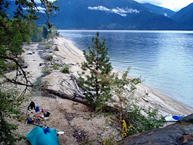
It stopped raining at around 10:00am and I gathered up my things and left paddling down the river toward Kootenai Lake if you could call it down as the water barely seemed to move if at all. I took the west branch of the Kootenai, which would dump out on the west side of the lake, which is where I wanted to be, on the less populated, wilder side. I knew I was getting close to the lake, because the river was more unsettled with waves building; the water becoming choppy. As I approached a railroad bridge I could see the lake beyond and the waves on the lake! Now I was getting worried! I pressed on through a strong headwind for about eleven miles, until I found a real nice south facing beach.
I quickly set up camp and got some dry pine needles and branches together to make a fire. After I got the fire going I set out on the beach and gathered up armfuls of driftwood, which I placed around the fire to dry. I also made a tripod with some longer branches which I began drying things on. With the fire going I put a foil wrapped potato into the coals and went down to the lake to clean a 10 Kokoanee trout I had caught while trolling across the lake. I had a great night, but woke up to rain at about four or five in the morning, which stopped around 6:30 am at which time I got the fire going again and drank my morning coffee. I could feel the wind coming up from the south so I hurriedly got my things together and packed my kayak up for the day.
 As I got into my kayak and attached the kilt to keep the water out I knew that I was going to get wet trying to get off the beach, and I did. The wind was steady as I set up my sail and I rounded the first point heading north toward the next point four or five miles in the distance. I was making good time with a steady tail wind, but the waves were increasing in size and it was beginning to look more and more like the ocean than the lake. The west shore was about of a mile to my left and the east shore was probably five miles to the right and I was about in the middle of the bay when I figured out I should have stayed on shore! It was too late to head back into the wind, which was howling about then, and the shore on my left was extremely rocky and the waves were crashing into those rocks. My only choice by that time was to head for the point and try to make it to some protected bay on the other side.
As I got closer to the point the water became increasingly more unsettled and the waves kept coming in increasingly larger and larger sets. I would paddle like hell to avoid getting broached by a wave from the side and then fly down its face and stab into the other side with my bow. This went on for about thirty minutes or so and I would push down as hard as I could on the rudder hoping it wouldnt break as I back paddled or paddled depending upon which way the wind and waves were throwing me. The point I was trying to round was coming up and the wind and waves were huge. I could not believe that waves were so big on a lake that size! By the time I reached the point I had to paddle as fast as I could, steering to the right to avoid being smashed into the rocks and trying to make sure I didnt get sidelined by the next wave. All the time I couldnt take the sail down as I didnt have a single moment to distract me from each and every wave that just kept coming, bashing into me from behind or from the side. If there was ever a time I thought that this is it was when I was approaching the point I would try to slow down as the wind and waves would try to push me into the next face, like surfing and I was sitting in a kayak! Finally, I made it past the point and the waves settled down just enough for me to make a hard left and sail into a protected bay with a very small sandy beach.
I pulled the kayak up onto the beach I felt completely drained of all my strength and just sat there thinking about what I had just been through. I emptied the water from inside my cockpit, and hung everything out to dry as I was completely soaked. The sun came and went as the clouds moved overhead. I explored the point that almost got me to find a good vantage spot to survey the lake beyond and think. I stayed there for about two hours listening to the waves hitting the rocks, which sounded just like thunder in the distance. As it started to sprinkle I noticed the wind had settled down. I decided to head out again, for the next point and beyond. This time I would keep my mast up, but the sail wrapped up. I couldnt keep it down, facing forward as usual; it would surely be ripped off so keeping it up with the sail wrapped was my only option. I also decided that I would stay farther out, the waves were still huge but I wouldnt have to deal with the unsettled water around the shoreline.
 With the sail wrapped and the wind settled down I could deal with the lake much easier, but the large waves coming in sets of five or six would try to suck me down the face and I would jam my paddle into the water to keep it from happening. This went on for at least a couple of hours and a couple of bays each with a point that would concentrate the power of the wind and water. Finally it settled down enough that the waves were like huge rolling hills and I could use them to my advantage, I didnt have to worry about stabbing into the next wave as they were spread out so much now I would paddle as hard as I could and ride the wave till it left me behind and then do the same thing on the next and the next. This went on til I reached the bend in the lake that would take me to the West Arm of Kootenai and Nelson, British Columbia. As I paddled on I saw a small fishing boat, then another and finally the ferry that travels back and forth from Balfour to Crawford Bay everyday. I paddled on toward the ferry landing at Balfour, passing under the pier, and I really wanted to get out and walk up to the bar there and have a drink, but I was soaking wet again and decided to keep going so that I could find a spot to set up camp for my final night before my wife Janet would meet me in Nelson the next evening.
I paddled about another five miles and found a sandy beach to set up my tent and dry out my things. It rained again that night and in the morning again I had to wait because it was raining so hard. Finally it stopped so I gathered my things together and headed west toward Nelson. I arrived at the 3A Bridge at Nelson at 4:25pm and continued on toward a marina. As I passed under the Bridge I noticed a boat launch ramp and park on the south side, but I wanted to go all the way into Nelson so I continued on in a very strong headwind. I knew that when I got to the marina I could turn around and have a nice mile sail back to the boat launch, which I did using my spinnaker for the first time of the trip. With the wind at my back I clocked 6 miles an hour with my G.P.S., now that was a perfect ending to my trip! I figured I had traveled approximately 150 miles in six days and five nights from Montana, through Idaho and into British Columbia, sometimes paddling for hours to make only a few miles in distance through the winding waters of the Kootenai.
Outfitting:
I used a Perception Eclipse 17' with a home-made sail (for those rare tailwind days).
Fees:
None.
Directions:
Put in is Troy Montana about 35 miles east of Bonners Ferry Idaho.
Resources:
I used "Paddle Routes of the Pacific Northwest" for portions of the trip.
Trip Details
- Trip Duration: Extended Trip
- Sport/Activity: Kayaking, Canoeing
- Skill Level: Intermediate
- Water Type: River/Creek (Up to Class II)