
Kenai Peninsula in Alaska - Extended Trip Report
Trip Overview
 Flight day June 20: With no sleep the night before and an early pickup for a 6:30am flight, I fall asleep at the gate in Seattle and miss my 12 noon flight to Anchorage. Im told every flight until the 7pm is oversold by 10 people, but they can put me stand by on each flight. I call Dan and hes got problems of his own; one hour after takeoff his plane lost radar and returned to Atlanta. We somehow arrived in ANC at around the same time.
Recommendation #1:
Gary Moody of Go Purple Shuttle. I, very stressed out, called Gary to let him know we were both delayed for several hours past our reserved pickup time. He gently told me to calm down and that hed come and get us whenever we got in. Whenever? I asked..Anytime? Yes, he said. Hed have to charge us an extra $40 if it was after midnight, but hed come get us. Wow!! This is Alaska where a tuna fish sandwich can cost $40. Gary was there waiting for us at 10pm. Ive never before, in a lifetime of taking cabs, hugged a driver at trips end.
We arrive at the Alaska Paddle Inn (www.alaskapaddleinn.com) at around 1am. A welcome sign is out, our tarps, bear spray and other random gear we wouldnt or couldnt fly with are laid out neatly on the porch, and the Lower Tide room is warm and cozy. Dan and I flip a coin for who gets the futon, he loses, and we both retire (me in a deliciously comfy bed made exclusively from driftwood by Allan, the innkeeper).
We meet Allan and Allison the next morning. After dropping me at the market for fresh fruit and veggies, shes off on a fishing trip and he helps us get our bearings. The launch is directly across the street. Thats all we need to know, but hes there to offer a novel based in the area, some salmon he smoked, advice on campsites, and pancake mix, in case we find blueberries. Really good folks and you dont have to be a kayaker to appreciate them: http://tinyurl.com/6h239l. But you do have to book early.
On to the paddling:
Launch day, June 21: Lowell Point, Resurrection Bay to Fox Island. 11 miles.
So many choices in this beautiful bay, but when Allan told us of the night he and Allison spent the night on the Fox Island sand spit watching Orcas, just a few yards away, rub their bellies on the rocks, the decision was made. No orcas, but a very pleasant site, great views and welcoming weather.
Day 2: Fox Island to Bear Glacier: 12.5 miles.
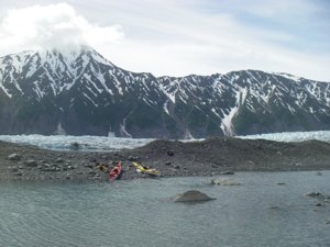
We can only get into Bear Glacier at high slack, for us, around 5pm. It works out perfectly and we get enough time to explore the south coast of Fox Island which has caves, arches, and fun water. The ride into Bear Gl. required attention but was pretty easy, but getting to the glacier, not so. The water is so shallow that we cant get a real stroke in to fight the 4+ knot glacial melt. I decide after a few tries and backslides (I stupidly tried the deeper water but the current was way too swift) that Im going to break my paddle and we stop about a mile short of our destination. We consider lining the kayaks so we can sleep nearer to the glacier, but were both cold and wet and dinner sounds better. We spent a sunny-blissful-iceberg-filled day in the Bear Glacier lagoons. This may be my favorite place on earth.
 Day 4: Bear Glacier to Aialik Fjord: 34 miles.
High wind and seas are forecast so we paddle for the nearest deep fjord for protection. Cape Aialik has a wicked reputation but were blessed with calm seas, bright sunshine, and no wind. We make our way around the cape and up the fjord and find orcas, dal porpoises, and a few whale watching boats, asking us where to find the orcas. The weather worsens and a very cold rain starts with low cloud cover; the weather is expected to be bad for 3-4 days. We find a deserted rangers cabin (locked) and make use the bear locker and 2 Quonset huts behind the cabin; one for drying our gear, the other for sleeping. It would have been warmer in our tents but it was good to be able to stretch out and the cots were comfortable enough. It rained hard for 3 days; on day 7 it stopped raining and I had a very close encounter with a black bear on the beach. Fortunately, the bear cooperated when I told it, very firmly, to get out of my camp. We had a fantastic paddle around Aialik Glacier, the most actively calving glacier wed ever seen. I even had the pleasure of surfing a small glacier wave. Pederson Glacier was less interesting, Abra Cove was spectacular, with a colorful, sheer rock face 1000+ feet high with dozens of waterfalls cascading down. On this last day in Aialik Fjord, we saw many groups of paddlers; we wouldnt see another paddler until the final day of our trip, and we saw a grand total of 3 boats until day 19.
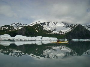
Day 9: Ailik Fjord to Northwestern Fjord: 32 mi.
Sunny, warm, light winds and an incredibly scenic paddle. We had lunch in our kayaks as there was no spot to take out. Were glad to see salmon starting to appear as the bears are feeding on nothing more than grass; there are no berries or salmon even though its almost July. Their scat looks more like horse manure than bear scat. We found an almost supernaturally beautiful campsite with a large freshwater stream made of pure snowmelt. The source was so steep that we didnt even bother to purify the delicious water. Next day was clear and almost warm. We paddled around the many glaciers of Northwestern Fjord with hundreds of seals and sea lions and their new pups hanging out on ice flows. We kept our distance to avoid endangering the pups. The rock formations along the shore are magnificent. Drifting along in the back eddies a few inches from the vertical walls, and reading the story that is told in the rock was an almost mystical experience. This was one of my favorite days ever in a kayak.
Day 11: Northwest Fjord to Cloudy Mountain: 17 miles.
This paddle gave us our first taste of the unpredictable conditions of coastal Alaska. The day started sunny, warm, and windless. We had several humpbacks surfacing very close by and we were enjoying spending time with them as we didnt have far to paddle, the weather was so perfect, and we knew exactly where we were going to camp; a coastal forest with a lagoon that was recommended by Tom Pogson. As we rounded the eastern headland of Two Arm Bay, the wind went from zero to ~25 knots and the sea went from mirror flat to breaking over us. The transition was unbelievably sudden and lasted about 30 minutes. There was no time to talk during the blow but afterward we found wed both gone through the same thought process, something like: I feel safe, partner looks good, we can each rescue the other if need be, lets have fun with this. When we arrived at camp there were so many prints in the black sand; lots of grizzly adult and cub prints, and everywhere some kind of wolf or wolverine (we thought they were dog prints at first but there were no human prints). We took special care hanging the food that night and built a big fire as we felt vulnerable that evening, even though it was one of the loveliest campsites of the trip.
 Day 12: Cloudy Mountain to North Arm, Nuka Bay: 32 miles.
Up early to be sure we could catch the flood through Macarthur Pass. This was another impossibly scenic day. The weather is beautiful but the forecast is for high winds and rain. Because of concerns about timing, we bypass McCarty Glacier and go straight to North Arm. We find North Arm cabin (not easily, its well hidden in the woods). Given the forecast, were thrilled to find this very nice cabin with a (for joy!!) propane heater, empty over July 4th weekend. It quickly becomes apparent that this is a sadly underused cabin; the outhouse smells sweet & there is a thick layer of dust on everything. We arrive at low tide and hauling our gear and kayaks up to the cabin leaves us both feeling our age. Weve been unable to get weather reports since we left Aialik Fjord, so Maggie, Dans wife, has been text messaging the marine report to our sat phone every morning. We spend a few days resting and waiting for the rain to stop and the wind to drop, playing gin, reading, and planning our trip around Gore Point, which has a very bad reputation among mariners. The day before we left we paddled around the area, decided not to hike up to the 900 foot waterfall as the bear risk was too high (still no berries or salmon in the streams!) and had fun playing in the white water outwash of the various streams.
Day 15: North Arm to Tonsina Bay: 34 miles.
We paddle to Nuka Island, Petes Cove to pay homage to Josephine Slater, one of those amazing women pioneers; we saw the ruins of her fox farm and house but there are no obvious campsites so we paddle on towards Tonsina Bay, our departing point for the trip around Gore Point. The paddle there was spectacular with hundreds of outer islands, mossy lagoons, and of course the towering, snow covered mountains. We ended up getting our tents set up late, at 10:30pm and were cold and wet, its raining and we decide to skip dinner and just eat some high energy snacks. Were not looking forward to the bad weather for the next few days. We set up both tarps the next morning, the first time weve used them. The effort would have been wasted, as we spent almost the entire day in our tents reading and napping, but the tarps kindly caught enough fresh rainwater to fill all our containers.
Day 17: Tonsina Bay to Rocky Bay: 25 miles.
Winds were 15-20k from the east with a 7 ft. swell and it was a hard decision to leave the safety of Tonsina Bay, but the forecast called for a shift to the SW which would have been much worse for us, even if the wind speed was lower. We decide to go, and though around the point the water was very confused, it was manageable and once we got around, the wind at our backs and the swell going our way had us flying and laughing and smiling all the way to Rocky Bay. At this point we had no prior information about campsites; the book and National Geo map wed been using ended at Gore Point and we knew no one who had paddle this stretch, so we only had the nautical chart to figure out where to camp each night. Wed planned on Picnic Harbor as it looked very protected, but the forecast was excellent and we stayed on an unnamed and exquisite black sand beach on the eastern shore of Rocky Bay.
 Day 18: Rocky Bay to Port Chatham: 18 miles.
This days paddle was one of the best. We saw orcas spy hopping and hurling themselves free of the water, dozens of humpbacks, 1000s of puffins and other birds who for some reason came very close to us for the first time. The wind is still at our backs at around 20 knots, and there are some fun tidal races. The campsite is idyllic, but we are now hearing planes and saw a boat come into the harbor. We are obviously on native land and should have asked for a permit before leaving.
Day 19: Port Chatham to Port Graham: 20 miles.
A perfect paddling day, but were now hearing many more planes and seeing boats regularly. We zoomed along in fantastic tidal races at over 10 knots and had some really fun water. We see so many otters, many with babies, its warm and sunny, and the wind is still at our backs. We see the village at the head of English Bay and many boats. A few natives chatted with us and they appeared to be unconcerned about us camping on their land.
Day 20: Port Graham to Kachemak Bay:
We stopped in Seldovia, a town of 300 people; for a fantastic lunch, cold beer, and a look around. We paddled on to Kachemak Bay and camped within 12 miles of Homer.
Day 21:
Kachemack Bay is beautiful and full of small islands, some with homes on them. If reincarnation is an option, Id like to come back as either an otter or a resident of one of these homes.
Tom Pogson of Alaska Kayak School picked us up on the beach at Homer. We rented our kayaks from Tom this year and last. His gear is high quality, he knows the area and the people and the services better than anyone, and is generous with his knowledge. Tom recommended Alaska Paddle Inn and Gary Moody this year, and last year gave us fantastic advice on rarely visited areas on our trip around Prince William Sound. Great guy, great outfitter. (alaskakayakschool.com)
What worked:
- bringing back up water purification system.
My Mioxx stopped working, I suspect due to a degraded O-ring. We had a Katadyn pump filtration system as back up. - Chartbook Maker: turns a raster chart into chart books.
These are indispensable; thanks to NOAA for making these charts available online and to Sean for making this software. - Sea Line Seal Pak as ditch kit.
Worn around waist every day it stayed dry with all our emergency gear (ditch kit).
- Mioxx: see above.
This worked fine last year, may be poor maintenance on my part.
Outfitting:
Alaska Kayak School, Tom Pogson.Kayaks, spray skirts, bear spray, flares, sponges & pumps.
Lyn used NDK Explorer and Dan used a Valley Aquanaut.
Directions:
There's only one road, you can't get lost.Resources:
National Geo Recreational Map for Kenai Fjords"Exploring Alaska's Kenai Fjords" by David Wm. Muller
Kenai Fjords National Park by Trails Illustrated
Chart 16682 Resurrection Bay to Two Arm Bay
Chart 16681 Two Arm Bay to Gore Point
Chart 16645 Gore Point to Anchor Point
Chartbook Maker by Apocgraphy
Trip Details
- Skill Level: Advanced
- Water Type: Open Water/Ocean