
John Day River in Oregon
Trip Overview
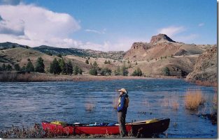 Last year my girlfriend and I drove from Canada down to the interior of Oregon, to canoe the John Day River. This river starts in the forested mountains to the east, then winds its way down through the dry interior to end in the Columbia River gorge.
We put in just east of the town of Monument, after arranging the shuttle with the friendly folks at Service Creek station (they run a business and shuttle service). We used the Soggy Sneakers paddling guidebook to help us prepare for the river and plan camping. The river was at a moderate level (2300 cfs) during our four day trip. Our take out was the Clarno bridge, and although a popular leg of the river continues to Cottonwood from here, we decided the Clarno Rapids (Grade 3) were a little above us, particularly because we were alone and there's no one around to help. Apparently you encounter these within a few kilometers from the bridge (we didn't see them).
The trip was truly spectacular and one of my best ever. Without question, the scenery here is breathtaking. This river runs though high desert canyon country, much of it ranch land with large exposed basalt ridges, and hills speckled with juniper trees, bunchgrass, and sagebrush. We only saw a few cattle, and even though the first two days followed along a highway, we rarely saw vehicles (this is way off the Interstate). After Service Creek the scenery does become more impressive and a real sense of isolation sets in. We saw one dorry boat on the river briefly, on the third day and that was it - we had the river and even the campgrounds to ourselves.
Anyway, to any avid canoe trippers, I would HIGHLY recommend this trip. Here are my two bits about preparation:
 1) The river rating in the guidebook is a little low. Basically I would add a "+" to every grade. My thinking, and this was confirmed later, that many of these desert rivers are rated by rafters and fishermen. For example, what they call "1+" is what we would consider a "2". The named rapids definitely require scouting. The only portage we did was on "Wreck Rapid", as we felt that being alone and considering the isolation, this was too risky to run. Most of the unnamed rapids are located at bends in the river, where with a slight gradient, the water piles up against cliff walls creating standing waves.
2) We camped at State run campgrounds (near Kimberly the first night, by Service Creek the second night), and at Burnt Ranch the third night. All the campgrounds with the exception of Burnt Ranch have picnic tables and outhouses. You are required to register to be on the river, but there is no fee for registration or camping. There is also the requirement to bring portable toilets (we just brought a pail with a secure lid).
3) Bring way more water than you think you need. There is nowhere to get water once you're out of Service Creek. We stopped in here on day 3 to fill up our containers.
4) If you're going in April, bring appropriate all weather gear. The pattern of the weather basically repeated itself every day. Wake up to clear skies, by noon it's hot, by 2 it's clouded over, and from 3-4pm it's raining with an intense headwind, and by 6pm it was clear, calm, and sunny again. Some storms did blow through in the night. We didn't even bother with a tarp as the first night we tried the wind ripped the grommets out of it. Tent was fine.
I would love to do a raft supported kayak trip of some other desert rivers -- like the Snake, Owhyee, Deschutes, Grande Ronde, and others. Their beauty is unparalleled as far as I'm concerned.
I have a couple pictures I could post with this article, so we'll see what the webmaster decides.
Outfitting:
Dagger Legend 16 with floatation bags in both ends. Outfitted with thigh straps and knee pads.
Trip Details
- Trip Duration: 2-3 Day Trip
- Sport/Activity: Kayaking, Canoeing
- Skill Level: Intermediate
- Water Type: River/Creek (Up to Class II)