
Green River Utah in Utah
Trip Overview
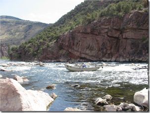
 Green River, below Flaming Gorge Dam
My son and I took our kayaks to this area for fly-fishing and some kayaking. We floated the 16 or so miles immediately below Flaming Gorge Dam in a guided McKenzie boat. This was both to maximize the fishing and to scout the river. I decided my son's kayak experience (flat water only) was not up to the river's demands, however moderate.
The rapids are Cl.2+ at their toughest, in my opinion. They are really perfect for casual kayakers, in that all but a few can be easily 'snuck,' portaged short distances, or of course, run. Except for a few rock gardens, most rapids are short and clear, dumping out into safe pools. This section of river is heavily floated by rafts, McKenzie boats, fly fisher's twin hulled float tubes, and (reportedly) kayaks in the summer. We saw many boats and float tube fishermen "running" the rapids.
The scenery is wonderful, with soaring red cliffs along the first 8 miles, and more open but beautiful lower down. Access is provided at regular intervals (about every 8 miles), with no practical access between launch points. There is a maintained trail along the first 8 miles, paralleling the river closely.
Water is consistent in temperature, in the 50 degree F range, coming through the dam. Summer temps can be really hot, amplified by the heat reflection/retention of the rock cliffs. Our September temps were comfortably cool, in the 60-70 degree range (much cooler until the sun gets on you).
 Above the dam is the reservoir, a huge impoundment with nearly vertical cliffs surrounding it (at least near the dam). Recreational ski boats and fishing boats abound, but the lake is so huge that there is room for everyone.
Camping areas are considerable in number, sophisticated in design. Flush toilets, hot showers, and campground attendants. Camping in these grounds is getting surprisingly expensive, with a $16.00 a day fee to throw down a small tent. Note after Labor Day, most of the forest service campgrounds close. One of the open ones, Dripping Springs, was burned a large forest fire in 2002. It has been rebuilt, but sits squarely in the burned area and is therefore esthetically pretty grim.
The town of Dutch John is tiny, with no food store. A few items, like milk, ice and pop, can be purchased at the two gas station stores. But for real food, you must drive to either Rock Springs, WY, Manila, UT or Vernal, UT. Each is about an hour's drive. There are two restaurants nearby, with moderate prices and surprisingly good food.
We plan to return next year, with wife in tow, to kayak and fish some more. This is a wonderful river, with not a house to be seen along the first 16 miles!
Directions:
I-80 for the east or west, to Rock Springs, WY. South about 40 miles on very good two lane Hy 191, the last few miles coming into Utah. Go to visitors center at the dam for free maps and general directions.
Trip Details
- Trip Duration: Day Trip
- Sport/Activity: Kayaking
- Skill Level: Intermediate
- Water Type: River/Creek (Up to Class II)