
Green River Utah in Utah
Trip Overview
Green River through Canyonlands - Mineral Bottom to Confluence of Colorado River
I drove into Moab on Saturday the 4th of April. It was the end of Jeep Week, which, upon seeing hundreds (probably more than a thousand) of Jeeps, made me think I had picked a poor time to come to Moab. I did manage to find a campsite north of town on the River Road, near Negro Bill Canyon.
Back in town, I left a message with my friend Ryan, who was driving from Minnesota to meet me for the trip. I had been looking for a vacation trip, and the stretch of the Green River through Canyonlands National Park came highly recommended. While researching the trip, I found an online article that described this exact trip, also paddled in sea kayaks.
I sent a link to the story to Ryan, who replied back in short time that he wanted to go. I asked him if he'd be good to go in about 2 weeks time. He came back a day later, and said he was in.
We planned the trip via Facebook messages. I came up with a gear list, he did as well, and I planned the daily itinerary of mileages and campsites. In fact, we didn't actually talk about the trip on the phone, until I was in Moab.
We spent Saturday and Sunday packing, drinking beer, and going for short day hike up Negro Bill Canyon, which is a wonderful short hike with a real desert slickrock flavor.
The trip really started on Monday morning. We drove to Tag-a-long, who we had hired to be our shuttle, driving us to the put-in, and picking us up on a jet boat at the confluence of the Green and Colorado rivers. We had all of our dry bags packed, ready to go with food, clothes, and camping gear.
We loaded our kayaks on the trailer, our dry bags in the van, and off we went north out of Moab, turning west, and driving under large cliffs of Wingate Sandstone, as our driver Buzz told us about the geological history of the area. The drive is somewhat of a long one, and the final descent to the river is steep and hair-raising. There are even a few old, wrecked cars that had crashed and burned many years before.
At the put-in, we packed our gear into our boats, barely fitting it all in. Ryan had never been in a kayak before, so I we pushed his boat into the water, and I helped stabilize it as he hopped in, attached the spray skirt and paddled away. I jumped in my boat, and we were off!
Labyrinth Canyon, as it's known at the beginning of the trip is walled with steep, tall cliffs of impressive sandstone. I'm also a climber, so perhaps they're more impressive to me than others. We paddled down river passing some other parties that were putting in at the same time as us. One of the more interesting vessels we saw was a catamaran made of two aluminum canoes, held together with metal cross bars. It appeared very stable, but ungainly, especially in the head wind coming up the river.
We paddled on a few miles and took a short break for a snack. After getting back in our boats, we paddled out, into a head wind that was gathering strength. I didn't mind it much, as I'd been climbing a good bit, and felt decently strong. Ryan, however, hadn't paddled at all this year yet, and was getting tired of the wind. We kept on, attempting to dodge the wind by switching sides of the rivers as we approached the many large oxbow bends the river has.
We rounded a large horseshoe bend, and, in a protected little cove, found a dry wash and access to an open camp site near Fort Bottom. It's a wonderful, open site with great views of cliffs and towers. Total mileage that day was approximately 13.
Day 2
I woke up early and enjoyed the sunrise with coffee, as I love to do. I sat quietly in camp and watched the cliffs change color as dawn broke. A large tree floated silently down the river. We packed up our things and carried bags down to the boats, that were down in the wash.
We paddled out the protected wash, down river and into the wind. The weather was great, clear, if a bit windy already. The breeze and proximity to the water kept the temperatures slightly cool for most of the trip. I wore a light long-sleeve synthetic shirt, a light buff to keep the sun of my head and a windshirt over my PFD.
This was planned to be a longer day of paddling. We hoped to do a 'double day' or about 20 miles, so we'd have a layover near the end, to do a day-hike into the Maze area of Canyonlands. We paddled south, entering the white rim layer of sandstone with short but steep cliffs coming directly out of the water. We passed a party of two and exchanged greetings.
Further down the river, we stopped at Bonita Bend, where we were told there was probably a water source. One has to let water collected from the river settle for hours before the sediment will fall to the bottom. Only then can one filter the water. A more preferable option for us was to find clear water sources, collect water in jugs, which we'd then treat with AquaMira. We got out of our boats at a campsite, and walked over to some cliffs, where there is a large cave easily visible, and an oasis of sorts, with trees and bushes growing out of the sand. We looked around on the ground, and saw no water. We scrambled up some broken little cliffs inside of the large cave, and found a pool of water, about the size of a bathtub. Such a cool thing to find in the middle of a huge desert.
We filled up the water jugs and went back to our boats, where we began to treat the water.
We took a short hike looking for petroglyphs, but didn't find them. All we found were snake tracks in the sand, which might have convinced us to go back to the boats.
After a snack, it was back in the boats, and around Bonita Bend. The wind was now coming mostly out of the west. This section of the river has many long oxbows, so heading east, we had tail winds, then rounding the next bend, we'd be battling a head wind for the next mile or two.
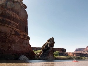
Around Valentine bottom, we saw cliff dwellings on the right. We also more impressive cliffs, and generally mind-blowing scenery. Past Valentine Bottom we saw more cliff dwellings, some impressively perched. Past Tuxedo Bottom, we planned to look for a camp on the far side of the Turk's Head. This location had been recommended. As we paddled, we went by a spot that in retrospect was the site we wanted, but didn't realize it until too late. The river is slow enough to paddle upstream, but fast enough that's it's slightly challenging to do so. I considered paddling back up to it, but Ryan preferred to head down river, and take the next site, near Deadhorse Canyon.
As we approached Deadhorse Canyon, I saw two men on the cliffs above. They were at the site we wanted. I felt fine paddling further, but Ryan seemed tired, and the winds were strong. We paddled past Deadhorse, and pulled to the shore on the left side of the river to look at the map and discuss our options. Ryan fell in the water exiting his boat, and was soon shivering.
I gave him my jacket, and we decided to grab the next possible site, nice or not.
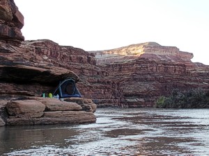 About a quarter mile downriver, in a straight and rather swift part of the river, I found a little square harbor, at the bottom of a small side canyon. I got out and looked around. It was a sandy and vegetated canyon, but there were nice flat rocks on the sides, near the water, that would be a nice place to hang out. We got out of our boats and started unloading.
Ryan found a high perch to set up his tent. I had the idea that I'd wedge my small solo tent onto one of the waterside ledges. We sat on the rocks, cooked, and enjoyed the evening. As it got dark, I managed to set up the mesh interior of my tent, on a shelf, under an overhang. It was rather close to a drop into the water, so I piled clothes under my sleeping pad, which kept me from rolling into the river. I watched the stars come out and listened to the gurgle of the river. It was one of the most amazing places I've ever slept.
Total mileage for day 2: about 22
Day 3
Again, I enjoyed my morning coffee, and started to pack my gear away. Our plan for the day was about another 12 miles or so, to reach our layover campsite near Water Canyon. We packed and headed off, again into the wind. It was cooler than the previous mornings, and the deeper canyon concentrated the wind. I was wearing my same outfit, with wind jacket, but as we made miles, I grew cold.
3 other kayakers passed us, and I chatted with them for a short bit. They said that the mouth of Water Canyon is a busy place to camp, often full. Ryan and I resolved to look for a site that was close to Water Canyon, but not at it. As we approached we could see several rafts, canoes, and kayaks at the mouth of Water Canyon, and found a site about a quarter mile upriver, on the same side.
 This was a precarious site, with our boats pulled up onto rocks, we scrambled up some 40 feet to a large open bench. Here was a nice camp site, obviously used before, but not much. A bonus was that one could continue down the shelf on a user trail, and easily approach the hike into the Maze. After setting up camp, we walked down to Water Canyon. I brought two water jugs with, and found clear pools of water in elegant limestone. Back at camp that evening we made plans for our hike.
Total mileage for the day was about 13.
Day 4
We woke relatively early, and were hiking around 7:30. The hike up out of the canyon bottom is mildly strenuous. It's a non-maintained trail up a loose and steep canyon. Above is a shelf that bars passage, and the trail sidesteps this. At it's narrowest, the shelf that one walks across is about 3 feet wide, with a drop of about 60 feet to the side. Past here, the hike is easy, pleasant walking up a sandy canyon bottom. True to its name, water can be found here. We hiked up and joined an official trail, spending the afternoon walking among red sandstone spires, canyons, and slickrock benches.
The Maze is an amazing place to hike, and approaching it via kayak and Water Canyon may be the most pleasant way to get to it.
Day 5
This was the last day of our trip, and we only had to paddle about 5 miles to our rendezvous site just past the Confluence. We paddled this in a short time, hoping to find a nice beach where we could be picked up, clean out our boats and dry gear before the boat ride out. The cockpit of my kayak had been collecting mud, and I wanted to give it a good rinse. We found a suitable place, and I set to placing my gear out in the sun, tipping the boat and washing it out, and pulling it onto land to dry.
I had just enough time to do this before we saw our boats. They located us, and went down river to collect others, with a plan to come back and get us last. An hour or so later they returned and we handed our gear aboard.
The boat ride was enjoyable, watching the cliffs as we headed upriver. I was zoning out, and enjoying the ride, when our two boats rounded a bend at high speed and beached on a sand bar. We all looked at each other, and realized we were actually stuck. Really stuck, and far away from Moab.
In the end, it took us all about 3 hours to get one boat off the sand bar. We piled all gear aboard the one boat, and took off. We had just enough day light to get to the boat ramp.
The rest of the ride went without incident, and we were back in Moab around 8pm.
Outfitting:
Sea Kayaks.
Mine is a Wilderness Systems Cape Horn 17
Fees:
NPS permit. Ours was $70 for two people.
Get it at nps.gov/cany
Shuttle cost about $170 each.
Arrange your shuttle first, then get the permit.
Directions:
Drive to Moab, UT and locate your outfitter. They will drive you to the put-in.
Launches:
Contact:
"Tag-a-long", for the river shuttle.
I thought they were a good company and would use them again.
Resources:
National Geographic Trails Illustrated - Island In The Sky
Google Earth to plan the Water Canyon/Maze Hike
The standard River Map guidebook = Belknap's Canyonlands River Guide
Trip Details
- Trip Duration: Extended Trip
- Sport/Activity: Kayaking
- Skill Level: Intermediate
- Water Type: River/Creek (Up to Class II)