
Great Dismal Swamp in Virginia
Trip Overview
Imagine the wildlife viewing opportunities of 100,000 acres of wild, wet woods, which has only a handful of human visitors per day. Now imagine theres a huge lake in the middle of it which is accessible by a long canal. Its a paddlers dream. Id wanted to visit Lake Drummond for several years, but lacked the touring range. Because it is located in the middle of the Great Dismal Swamp, just to lay eyeballs on it requires an 8.6 mile round trip from the public landing. Adding another 5-8 miles to circumnavigate the lake probably puts it out of a beginners reach as a day trip. This year I finally developed the range, let the bug populations decline in the fall, and waited for the highly recommended light winds.
At the Dismal Swamp boat ramp an hour after sunrise, the fog was thick and the water was almost opaque with the beautiful color of strong tea. Sticking my hand into the cold water, my fingers disappeared before my wrist was wet. The novelty of this blackwater evaporated any misgivings I had about heading to one of the loneliest spots on the east coast.
Fox grapevines and disintegrating wooden bulkheads characterized the short paddle down the 50 wide Intracoastal Waterway. There was no power boat traffic this early. Spider webs sagged, replete with their catch of water droplets. American Beauty Berry grew on the bank, its fruit flushing from white to purple ivory. Whenever I stopped to take pictures, I could hear the trees turn the fog into a heavy patter within their drip lines.
Turning right into the 30 wide Feeder Ditch, the vines continued their grape-less riot. There was a 0.5 mph opposing current caused by overflow from the lake feeding the Intracoastal Waterway (hence the name, Feeder Ditch). Despite the jungle-y overgrowth, you feel in your bones the canal is unnatural since it is straight as an arrow and the elevation of the 8-10 high banks hardly varies. But the banks arent actually high; theyre about the same elevation as the swamp. Its the canal that was dug down deep to keep it full of groundwater and runoff.
Muddy wildlife slides are frequently seen, as well as swirls from medium sized fish. Large rusty pipes drain the surrounding woods and agricultural areas into the Feeder Ditch. About half-way to the lake, the character of the land changes. Modern-looking fossil oysters and clams, exposed by digging the canal, indicate this area was once an estuary. Two under-story trees begin to appear in profusion, lace-leaved mimosa and paw-paw with its large, long leaves. Paw-paw fruit are tasty but, like the fox grapes, I was a few weeks too late. While I stopped to look at some shapely driftwood, a wary female duck paddled by, so butt-ugly with her strange Neanderthal brow she could stop traffic.
An unexpected phenomenon for me in the upper Feeder Ditch was swamp suds. Wherever water poured into the ditch, it created rafts of stiff brownish white suds. By the time I got to the end of the canal, the suds were 2 feet thick just below the roaring spillway. It looked like an overflowing washing machine from a Disney family movie.
Campgrounds lie on both sides of the thick foam marking the spillway. Bearing left of the spillway and a dagger-like peninsula, you enter quiet backwaters where you can take-out for a short 30 portage. Theres an electric boat trolley to haul power boats up to the lake level. I tried it for the experience but regretted it almost immediately because its horribly slow. So I amused myself watching colorful toads risk death by hopping around the trolley rails. For a campground in the middle of nowhere, the Army Corps of Engineers has outdone itself: besides the spillway caretakers office building, there are picnic tables, bathrooms with flush toilets (but no potable water), two pavilions with heavy screens to discourage animals pilfering food, and a handful of picnic tables. Theres a safe path over the spillway to a wide grassy area for campers who need a little more elbow room.
After a break and a chat with the spillway caretaker, I put in at the 8 higher lake level, only a bit lower than the surrounding woods. The day was going well so I was surprised to feel my mood lift. Evidently, the confining banks of the Feeder Ditch had been oppressive at a subconscious level. A short paddle through a tunnel of woods filled with small birds then led to the entrance of the lake.
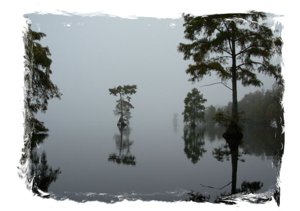
 It was magical. Toward what should be the lake center, the sky diffused into water without a hint of a horizon, giving an impression of infinite expanse. The fog was thin enough to allow me to see trees along the near shoreline, reflected in the obsidian mirror of the water. Bald cypress trees inside the rim of the lake were so distorted as to be superficially unrecognizable as members of their species. For an hour, I lost all interest in circumnavigating the lake. Paddling doesnt get much better than weaving around reddish-brown bald cypress knees (sometimes even under the arching roots), with thick ropes of Spanish moss hanging from the branches, and spider webs highlighted by fog droplets. It was only 10 AM and already the best day Id had all year.
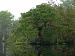
These trees, looking as tortured as if they had been plucked off some basalt headland on the Oregon Coast, haunted me for days. Eventually, it dawned on me that they looked so odd because they were probably the oldest collection of bald cypress Ive met. Bald cypress can indeed live a long time, but to reach a 1000th birthday, good genes arent enough; you also have to be lucky. These 25 bonsai were presumably too twisted and inconveniently located to interest loggers, and their location inside the rim of the lake (but not too far inside the rim) may have given them greater protection from fire, drought, root scour, and wind. They are much more likely to live to great age than those I see along tidal rivers, which have to face much greater levels of erosion as well as salt poisoning.
Sated at last, I memorized the Feeder Ditch entrance from the perspective of someone (me) coming from the south later in the day, thankfully noted a large reflective blaze on one of the trees, then began a slow counter-clockwise loop. Strange bits of history are sparsely scattered around the lake: the pilings of an old pier which burned almost to the waterline, deteriorating docks, the top of an old exploded propane tank. Most of my paddling was in 2-4 of water with a surprisingly hard, sandy bottom. How could a shallow lake surrounded by miles of leafy forest not have a muck bottom? The water sample I brought home precipitated little clots of organic material after a few weeks, so its not only tannins that drain out of the lake.
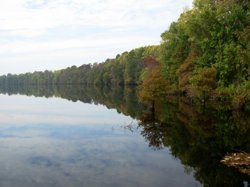 The trees along the shore were turning color and loaded with late-season fruit: the swamp tupelo with their elongated purple fruit speckled with gold, heavy crops of plump blueberry-like fruit of the black tupelo, and even the bald cypress with their tight green nut-like cones. Squirrels eating the latter made a lot of noise as they dropped chunks into the water below. As the morning advanced and the fog finally cleared, the opposite shoreline changed from a smudgy gray caterpillar to a line of colorful trees about 2.5 miles away.
The sun had just finished burning off the fog when I saw the little bear. I had been picking along the shoreline fairly quietly when I heard something making a bit less noise than a squirrel. More used to TV bears than real bears, I had been looking for hulking brutes along the shoreline. This 100 lb cutie was 25 up a medium sized black tupelo tree eating the berries. When he realized he had company, he took a moment to get a good grip, carefully slid down the tree and disappeared into the woods. It was already late morning and seemed too warm for climbing trees in fur coats, so I figured this would be my only bear sighting for the day.
With ears peeled, I examined the black tupelo tree fruit which now seemed much less like a blueberry, consisting mostly of an oblong seed covered with a little lime-green flesh and no remarkable smell. Some large scat I found along one of the ditches, covered with two inches of white hair-like fungi, was basically a pile of such seeds. Moving on, as I paddled between two trees, a huge splash occurred practically under my armpit. (Scream away on Lake Drummond without fear of wounded pride. Absolutely no one will hear you.) Dripping wet and very confused, it took me minutes to realize that it wasnt a tree-diving bear, but just a big fish. This unnerved me though, so I took off my floppy hat to better scan the treetops for extremely large, black squirrels.
Around lunch-time, I took a break at the Washington Ditch pier. The Washington Ditch was relatively free of dead-fall (speaking very relatively) and was the only obvious point-source of flow into the lake. It may be responsible for the lake current, which is so weak only a tide-jockey would notice. As I ate lunch, walking just one block, I saw a large deer limp back into the forest; a muskrat dove in the ditch and roiled the waters; a small bird fearlessly studied me from a nearby tree hoping to find out what a crumb of beef jerky tasted like. Though I had eyed the landing suspiciously as a great potential basking site for cottonmouths, it was apparently too late in the season.
While no single tree in this area can hold a candle to the ancients near the Feeder Ditch entrance, the prettiest stretch of fall color lay to the west of the Washington Ditch. The NW section holds other scenic gems too. Because Spanish moss is at its northern limit in the Great Dismal Swamp, it grows patchily, yet one memorable tree was absolutely bearded with it. Nearby, an old hunting shack lay collapsed on its side in a pool of black ink. The weak wind had almost died, so the lake surface had turned back into a mirror. The illusion of two indistinguishable skies was dizzying. Usually, I take my kayaks buoyancy for granted. Today, it was all that was keeping from sinking into that mirror world.
The western shore appears to have been hit hard by a combination of storm and intense fire, leaving few surviving older trees except those that live in or near the water. A single bald eagle flew by. Turtles plopped into the water as soon as they saw the snout of my kayak, leaving nothing but splashes for my eyes. Looking behind me, a half mile trail of thin swamp suds marked my route, as if by a toy speedboat. How many power boats would it take, I wondered, to turn Lake Drummond into the largest bubble bath in the world? You cant reproduce the effect with strong tea at home, so its not simply the tannins. Its easy to blame agricultural run-off for the suds, but I wonder if it could be due to alkali from the wood ashes of the forest fire combining with fatty acids in the water (i.e., the formula for soap).
 Since I was doing a counterclockwise loop, this is where I had to pay a small wind-tax to a strengthening SW wind. But I forgot all about the wind when I saw the second larger (200 lb) bear. She was about 20 up a relatively large black tupelo tree. At first she didnt notice me, but probably heard my knees knocking together as I struggled to remove a camera from a zip-lock bag. For a while, she tried hiding behind the trunk. My daughter and I once saw an otter hide behind a stump to spy on us; the sight made my hair stand on end. But here, with the bears rotund belly bulging on either side of the trunk, the effect was only comical. She gave up trying to hide, slowly slid down into the surprisingly deep water, and swam to shore.
Although the plumpest bunches of black tupelo berries hang in easy reach over water only 2 deep, both bears chose to climb a tree rather than stand in a little cold water. Clearly, climbing a tree to get away from the rare aggressive black bear would be as useless as smearing your ass with liverwurst and trying to run away from a starving Doberman.
By mid-afternoon, the fish were jumping. I took a break at the Interior Ditch which is also the landing from which commercial paddling tours begin. An extended family had driven down one of the few drivable roads to look at the lake. With no other cars parked in the lot, they were confused to meet someone paddling out of a lake surrounded by an apparently unbroken line of trees. It felt good to have a quiet snack on this large pier in the middle of nowhere in the company of fellow humans. But we were from different worlds. While they were preoccupied with driving to North Carolina in one hour, I was preoccupied with paddling only a handful of miles before darkness fell.
Resuming, I passed one of the most funky bald cypress trees on the lake, with one arching root large enough to paddle under. This and other old trees on the lake suggest that the lake level is about 3 lower now than when these trees were young. The woods on the south part of the lake were thick and wild. They were fronted by an area of photogenic tree stumps which have been colonized by colorful bushes and small trees, each stump like a little Lost World. The lake may be migrating toward the S or SW, retreating from noreasters.
Enormous logs lie in the shallow water hundreds of meters from shore. If they are from bald cypress trees, then the submerged portions may survive many hundreds of years, like the paleo-indian dugout canoes found on the bottom of Lake Phelps in North Carolina. Those canoes were found in that lakes clear water during an extremely low water period. But given that Lake Drummond has only 3 water visibility and is too shallow for sonar, the only hope for a nondestructive search may be ground penetrating radar.
The lake at this time had very limited birdlife. The opaque water presumably makes it hard for fish eaters, and the small birds apparently stay in the woods to avoid becoming snacks. Besides the eagle I saw, there was a lone cormorant and a small flock of those Neanderthal ducks who kept to dense, flooded cover. The male ducks had a similar brow to the females but had coloration whose beauty was almost on par with the incomparable wood duck. I was unable to positively identify them but it seems to have been an uncommon variety of eider. In contrast to the paucity of birds, there seemed to be plenty of fish activity. The fish may appreciate the fact that the lake appears to be a drowning trap for small swamp creatures that cant handle miles of cold, open water. In addition to many drowned large insects on the surface of the water, I found a somewhat wolfish looking, mouse-like animal which was completely unfamiliar to me. Contact me for high resolution photos if you want to try identifying the were-mouse.
Using a GPS and approximate coordinates taken from a map, I had little trouble finding the old filled ditches. The most subtle was the last, the Riddick canal. Although all ditches were at least partly blocked by deadfall, each was marked: by a disintegrating pier, or a blaze on a tree, or an earthen dam, or in one case a low concrete dam with an open steel door. If these ditches were ever really filled, then the fill must have settled over the years. One might consider exploring these ditches in winter, when skirting deadfall simply means going around a dead tree, and not a dead tree covered with poison ivy, a basking cottonmouth, and a cloud of biting insects.
From the distinctive trees and the tree-blaze, it seemed easy to find the Feeder Ditch again. But of course I always knew roughly where I was with an occasional glance at the GPS. Now occupying the campground was a group of high school students from Newport News who had arrived in canoes. The weak outgoing current of the Feeder Ditch was appreciated, but the colder water and twilight were not. Amazingly, you can look straight down the narrow canal for miles and see the T-intersection it makes with the Intracoastal Waterway. The yachties had finally gotten out of bed, and even at low speeds their wakes were sloshing the waters of the narrow ICW canal like a bathtub.
This is a trip of great regional (perhaps even national) interest for scenery, plant life, and wildlife. The fishing might be good as well. Birders might do better walking the Washington Ditch trail. The outlined trip was 17.5 miles in 9.25 hours. Beginners probably need to camp. You could turn a Scout troop loose at the Feeder Ditch exit to Lake Drummond in canoes or kayaks, and they could entertain themselves for half a day without straying too far. Theres no need to circumnavigate the lake. The relatively shallow water warms up fast: my neighbor said his scouts were swimming on the lake already in late spring. Intermediate tourers can get an overview as I did in one long day. My only experience so far was on a day with minimal wind which really helped to bring out the dizzying natural beauty of the blackwater. But published sources warn about the wind hazard. The lake is a shallow bowl, 2 deep along the edge to reputedly only 6 deep in the middle. Even in a moderate wind, the 2+ mile diameter lake has plenty of fetch to generate breaking waves along the unprotected shoreline.
A map, compass, and watch, are essential. GPS is strongly suggested. (Without a GPS, bring binoculars to help spot blazes or uniquely twisted bald cypress landmarks from afar.) Unless youre familiar with the lake, one section looks a lot like another, and the few hard reference points like piers are miles apart. It doesnt take long following a circular route to lose your sense of direction, especially since the shoreline meanders. Without an occasional look at GPS, the long stretches between landmarks would have been nerve-wracking. But the real advantage of GPS is that if one had to abandon the circumnavigation for any reason, you could run straight to the Feeder Ditch exit. Thats not possible with a map and compass unless you know your exact starting point.
Accommodations:
Possibly a port-a-john. Plenty of parking space.
Fees:
No Fees
Directions:
From North Carolina, head north on Rt. 17.
From Virginia, although the roads are in good condition, youre probably going to get lost for a little while unless you think like the people at VDOT and are an offspring of first cousins. With a recent map in hand, you might try driving south on Business 17 from interstate 64 near Portsmouth. Watch for signs and the circular drive which marks the landing. You could easily end up on another Rt 17 which is parallel to the desired one. If you hit North Carolina, enjoy their Welcome Center before you turn around.
Resources:
Aerial photos and topo maps from www.terraserver.microsoft.com were useful.
The CBOFS wind forecast for the Chesapeake Bay area can be found http://tidesandcurrents.noaa.gov/ofs/cbofs/wind_forecast.shtml
Eastern Trees, a Peterson Field Guide, by G. A. Petrides and J. Wehr. In case Im not using your favorite common names, water tupelo is Nyssa aquatica, and black tupelo is Nyssa sylvatica . Fleshy bitter fruits are relished by black bear
Sea Kayaking Virginia, by Andrea J. Nolan
Virginia, a Guide to Backcountry Travel and Adventure, by James Bannon
Trip Details
- Trip Duration: Day Trip
- Sport/Activity: Kayaking, Canoeing
- Skill Level: Intermediate
- Water Type: Flat/Sheltered Water