
Fisherman Island NWR in Virginia
Trip Overview
My friend Dave wanted to visit Fisherman Island for bird watching. At first I balked, given the fact that neither of our kayaks had ever tasted water that big, cold, and salty. He countered that it was a good season for birds, the water was only going to get colder, and the weather report for this Thanksgiving weekend was ridiculously nice. So, warming up to the idea, I agreed to let him drive and finally bought a wetsuit.
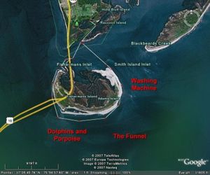
Fisherman Island NWR sits just below the southern tip of the Delmarva Peninsula, a last stepping stone before the Bridge-Tunnel alternately leaps and dives across the mouth of the Chesapeake Bay. The island looks like a letter U drawn in sand, with an arc of low forest poured into the bottom, then filled to the top by marshes. Migrating birds are funneled onto the island which provides cover, resting, feeding, and nesting sites. Here, the mouth of the Chesapeake Bay meets the Atlantic longshore drift, choking the area with sand, and making it risky for all but the shallowest draft power boats. Not only is no boat landing allowed in the NWR, but the boundaries extend to the adjacent ocean bottom as well, so no trespassing means that you have no wet-sand privileges unless youre a sand dollar.
Our put-in was at Eastern Shore NWR. The operative word in any description of eastern shore landings is always mud, so we began 1.5 hours before high tide. The water temperature was about 54 F, with an expected high air temperature in the low but comfortable 60s. Moderate winds were expected to vary from NE to E as the day progressed.
We paddled 0.5 mile through a narrow creek which widened as it wound through the marshes, allowing Dave to spot birds and me, already overheated in my new Farmer Johns, to remove some layers. In contrast to the threadbare look of freshwater marshes this time of year, the saltwater marshes were only a little yellowed. We were paddling against the tide, but the current was dying and we were fresh. The marsh creek took us to a short dredged canal called the Virginia Inside Passageway. Passing down the VIP led us past an anchored barge and finally into Fishermans Inlet. Directly across the inlet lay Fisherman Island. To our right was the highway bridge spanning the inlet.
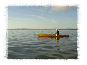
Daves Pungo 120 looks like a bathtub with its 5 long open cockpit, but Im just envious because it zips along like a water-strider. Id like to think my Prowler 13 looks more formidable, rather like the Washington Monument laying on its side with unfortunately about the same acceleration. To cruise at 4 mph, steam would have to be coming out of my ears. If Dave werent constantly stopping to squint through binoculars, my lagging behind would become embarrassing.
So I was a little concerned about the potential cross-tide in Fishermans inlet. Worst-case scenario was getting sucked into the Chesapeake Bay, there to spend hours dodging cargo vessels before being spit out again into the Atlantic. Fortunately, the dying current only exceeded 2 mph under the bridge. But have respect for the tides here at peak flow, its probably strong enough to spin little whirlpools off the bridge pylons and make those slurpy bathtub drain sounds.
There was plenty of chop under the bridge as waves from different directions pin-balled off the bridge pylons. But as soon as we reached the west side of the island, the water calmed. Still, small Bay waves could be seen perplexingly climbing upwind. In this area where big water meets big water, the local winds merely make suggestions while the surf seems dictated by distant masters.
On the west side, we found a few birds swimming offshore, and many more resting in a nearby marsh gut. Copious worn shells were mixed into the sandbars. A kayak fisherman was far ahead of us, but he somehow disappeared before we could draw close enough to say hello. Overhead, a river of birds winged north: mostly black vultures gliding at their usual waiting-for-something-to-die pace, while the few hawks were easy to pick out by their got-to-go-kill-something earnesty.
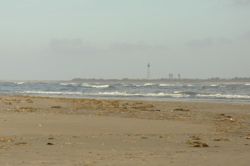
We met the bridge again on the SW side of the island where it begins to cross the Bay. As we paddled under its imposing legs, we saw the Atlantic surf for the first time. If life were a cartoon, this is the part where our eyes would bug out. White-caps were visible over a hundred yards from shore where 4 waves began breaking. But, perhaps even more intimidating, we could also occasionally see low hills of water sliding across the horizon. Having grown up in Iowa, I had never seen a hill on the water before. But now that Ive seen Poseidons shoulders, Im much more sympathetic to mythology.
It was decision time. The weather was great, we had been making good progress, and if things got too rough we could turn tail and have the wind and tide in our favor. We could avoid the breaking surf by simply paddling several hundred yards offshore. And so our visit became an attempted circumnavigation.
Paddling far from shore, there wasnt a lot to see. The scrubby maritime forest on our left hand side was no thing of beauty. Clearly, the ocean was really mad at that beach. To the rear, there was a mile-high tornado of vultures whirling over the bridge landing, a vision from the end of the world. Otherwise, not so good for bird-watching.
Further along, the very largest swells began breaking on our right hand side. My instinct is to flee what I dont understand, but former surfer Dave explained that there must be a submerged bar. We continued into the wide field of bouncy, but at least not vertical, water between the on-shore and off-shore breaks.
 Up ahead, several bullet shapes 4 long thrashed the water in unison. Theres nothing quite like dorsal fins to bring the world into sharp focus when youre sitting in a large bobber. We stopped dead in the water, and watched. With black backs and light grey undersides, they werent immediately recognizable. From their coloring, relatively small size, and behavior they were probably harbor porpoises. Minutes later, a pair of 8 long animals also porpoised nearby, easily recognizable as Atlantic bottle-nosed dolphins. One usually expects Flipper to dress in grey, but these were the color of a latte. In some parts of the world, bottle-nosed dolphins will attack and kill harbor porpoises. But if there was any aggression between the species it wasnt obvious; more like a traffic jam near a school of fish.
As we continued, the bottle-nosed dolphins surfaced every few minutes 100 yards away while the harbor porpoises moved 300-500 yards ahead. Picture taking conditions werent good: we were rocking up and down, and had to watch one others backs for the occasional half-hearted late breaking wave. I strongly suspect that, when we stopped paddling, these wary animals lost sound of us and fled. They were much wilder than those I hear about near Virginia Beach. Of the many pictures snapped, we got only a few dorsal fins and a lot of water. Successful nature photographers are underappreciated gods.
Our navigational landmark was a tower which appeared to be in the middle of Fisherman Island, but was actually 3+ miles further NE on neighboring Smith Island. As we progressed against the mild headwind, the tower drew closer to the limb of Fisherman Island. As the shoreline was monotonous, this was our only concrete measure of progress. Earlier, just as I opened the gasketed battery compartment of my GPS to replace the exhausted AAs yet again, a small wave broke over me. I heard one last zebra finch-like beep and the screen died. Just as well: the sucking sound was driving me crazy.
As we approached the eastern end of the island, our relatively calm field of water narrowed, and the end of the funnel it looked like someone had flushed the toilet. Dave didnt like my idea of slipping through the offshore break and paddling half-way to Africa in search of calmer water. Peering ahead, he could see wed eventually have to come back through the mile of breaking waves which stands between Fisherman Island and Smith Island. The real choices were to retrace our long path and lose the daylight before we returned to the put-in, or land on the flats and drag the boats past the rough area. We chose the latter option, pleading emergency, since we had painted ourselves into a corner, safety-wise. Fortunately, the shore break had lost much of the fury we had seen earlier, so we were able to scramble in without Daves bathtub getting too full.
Although it was only an hour past high tide, there were already hundreds of yards of wet sand so hard you could drive a car on it. Fisherman and Smith Islands have undoubtedly been joined in the past and will be again some day. Between them the water is only a few feet deep at mean low tide, so todays ocean swells had turned that space into an enormous washing machine. With 2 breaking waves, it looked like no fun in an SOT and probably a disaster in a regular kayak without a spray skirt. So we were committed to more than just a short drag: it was mile to the NE corner of the island.
 My Prowler 13 weighs only 54 lbs with the rudder option, but with two pairs of paddles, a small cooler, water bottles, see-bag, a large dry bag with emergency supplies, it weighed about 85 lbs. I always carry a soft, thick rope for dragging when the water gets too shallow for paddling; it works great in a couple of inches of flat water. But in pure sand I might as well have been dragging a beached pilot whale. This forced me into water deep enough not to be grounded every time the waves withdrew. My new wetsuit let me walk through the cold surf with impunity, but the occasional crashing wave would spread my toys all over the beach. Once I even had to run back to look for a missing paddle.
While I struggled in the surf like a mating grunion, Dave hefted his kayak on his shoulder and hiked. A strong guy can make it look easy. We would hike 1/8 mile and then both pretend to be interested in something in the sand and take a break. Once we reached the calm NE side of the island, we immediately put in again. There is a large marsh gut likely full of birds. Unfortunately, we were running out of daylight so didnt dawdle. We crossed back over to the mainland heading north near peak ebb flow, and arrived pointed almost due west. The current increased even further as we entered the Virginia Inside Passage, which was a tough way to end the day. But, tired and wet as we were, the birds seemed to sense we were harmless. A fat kingfisher on a post let us approach closely, and a cormorant caught fish and stopped to swallow them just a few feet in front of the kayaks.
The several marsh guts to our left all looked alike, but fortunately Dave remembered which one would get us back to the put-in. The water in the marsh creek was getting quite shallow, but we noted that it had a relatively firm, sandy bottom in the middle of the channel. That might be helpful to know if poling or wading is required. Back at the landing we had to slip through about 10 of gooey mud to get ashore.
This area is of great regional interest for bird-watching and possibly observing the bottle-nosed dolphin and the harbor porpoise (bearing in mind that either species might have been migrating through). However, the circumnavigation may not be practical except by advanced kayakers. With 20/20 hindsight, aerial photos from multiple sources indicate the surf conditions we saw on the south and east sides of the island are typical; certainly beyond the skill level of a couple of chuckleheads like us. (Im no photo-reconnaissance expert, but any surf you can see on meter-scale aerial photos is nasty.) If I hadnt bought a wetsuit, or if one of us werent in shape to pull/carry a kayak a half mile, the day would not have ended so well.
An appropriate trip for intermediate to advanced paddlers, less exposed to the Atlantic surf, would be to paddle across to Fisherman Island, and explore the large marsh guts on the northern and western sides. Signs in principle specify the boundaries, but given the frequent resculpting of the island, you can creep into a marsh gut and find yourself apparently prohibited from leaving by the same path! So check both sides of the signs. Get to the landing within 3 hours of high tide to minimize mud issues, and if possible design the trip to fight the current as little as possible. Note that theres plenty of open water on the north side of the island, so high winds could make that rough as well.
My buddy Dave was happy with the bird-watching. His list for the day: Canada goose, American oystercatcher, Brant, Black-crowned night heron, Pied-billed grebe, Common merganser, Piping plover, Willet, Lesser yellowlegs, Black vultures, Double-crested cormorants, Bufflehead, Great blue heron, Great white egret, Brown pelican, Yellow-rumped warbler, Great black back gull, Ring billed gull, Herring gull, Swan (unidentified), and Hawk (unidentified).
Fees:
No Fees
Directions:
The landing is located in the Eastern Shore National NWR near the southern tip of the Delmarva Peninsula. Basic directions can be found at the refuge profile at www.fws.gov/refuges/profiles/index.cfm?id=51650.
Launches:
Gravel-over-mud small boat landing on a tidal marsh creek. Enough room for a handful of cars to park. At the time of writing, mid-week road closures announced at www.fws.gov/northeast/easternshore/ may prevent access to the landing.
Resources:
Aerial photos and topo maps from http://www.terraserver.microsoft.com were useful, as were virtual tours via Google Earth.
The Fisherman Island webpage at www.fws.gov/northeast/easternshore/Fisherman%20Island/FI%20Gen%20Info.htm has a great aerial photo looking to the east. In retrospect, it shows similar surf conditions to those we encountered, as well as massive sediment plumes to the right of the bridge pylons generated by a strong outgoing tide.
I use http://tbone.biol.sc.edu/tide/ for tide predictions.
The CBOFS wind forecast for the Chesapeake Bay area can be found at http://tidesandcurrents.noaa.gov/ofs/cbofs/wind_forecast.shtml.
Getting a surf report would be a good idea, but Im not sufficiently familiar with the few mid-Atlantic options to recommend one.
Books:
"Whales, Dolphins, and Porpoises" by M. Carwardine, illustrated by Martin Camm, Smithsonian Handbooks, c2002.
"Sea-Kayaking Along the Mid-Atlantic Coast" by Tamsin Venn, c1994.
"Sea Kayaking Virginia" by Andrea J. Nolan, c2005.
Trip Details
- Trip Duration: Day Trip
- Sport/Activity: Kayaking, Canoeing
- Skill Level: Advanced
- Water Type: Open Water/Ocean