
Falls of the Ohio in Indiana
Trip Overview
 Kayaking the Falls of the Ohio
My friend, T. Rex, lives in North Carolina. I lived in Arizona. We hadn't seen each other for several years, and somehow we both got the itch for kayaking about the same time. After I moved to the Louisville, KY area, he brought his boat up for a visit. We decided to try the Falls of the Ohio, already one of my favorite places to hike, and see what it was like.
The Falls are a wild area in the middle of the Ohio River , between Clarksville, IN and downtown Louisville, KY. It was the true starting point of the Lewis and Clark Expedition, where they joined up at the home of George Rogers Clark, who lived at the Falls, before heading out to St. Louis. John James Audubon sketched birds here while living in Louisville. These days the Falls are mostly under water and under the McAlpine Dam. What's left is an amazing array of rocks, fossils and canyons. If the dam gates are wide open to let the flood water through, it's all under wild water and you couldn't go near it in any kind of boat. When the gates are closed, it's very calm and easy to paddle the winding path through the rock outcroppings.
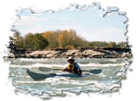
 We put in at a ramp in Clarksville and paddled out to the middle of the river, near the gates at the lower end of the dam. The rain from the night before left quite a bit of water running through so we kept a cautious distance. From there we went upriver past the old stone and concrete weir that is gradually collapsing, and into the winding course the river follows through the rocks.
It was a wonderful, warm October afternoon, the leaves were turning all colors under a blue sky. The birds were everywhere, Herons, Gulls, Osprey, Ducks and Coots They allowed us to get close enough for a good look before flying off. The rock cliffs and fossil beds by the Falls of the Ohio State Park, on the Indiana shore, were full of folks strolling and relaxing. One thing about kayaking in this area, you will get plenty of stares. There aren't many around here.
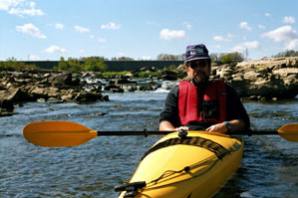 These falls were not a solid drop, but more like a long series of rapids, originally dropping 26 feet in 2 1/2 miles. There are a few spots left where the water does actually run through some remnants of the falls. Small paths left below the dam allow the river to drop through the original courses. We paddled up one of these small canyons and discovered we'd cornered some large fish. They each made their own mad dash for the deeper river, some almost crawling over the shallow rocks, their upper halves out of the water. I'm not a fisherman and didn't have a real clear view of them. They looked like carp, about 2 feet long.
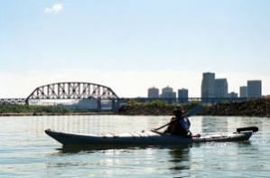 One of the amazing things about this spot is the proximity of the wildness to the city. As you look up from the rocks and river, you see the Louisville skyline beyond the dam and several bridges over the river. We paddled as far upriver as we could, till the rapids were too shallow, right below the upper part of the dam, and below the train bridge.
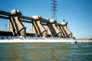
We poked around the pools among the rocks as we worked our way back down river. By the time we got to the lower gates, the flow had dropped off enough that we felt comfortable getting pretty close. Below this there remains one small string of rapids strung across the river between the Indiana shore and Sand Island, which is next to the McAlpine Locks. There we came across a kayaker working out in the rapids, practicing all kinds of maneuvers. We managed to have a few words with him, finding out that he was from Lithuania and a former member of the Soviet slalom team.
According to the GPS, we'd done about 6 miles in the wind and current. My arms said it was enough. We will be back.
Directions:
Access ramp is located by the George Rogers Clark Homesite at the western end of Harrison Ave. in Clarksville, IN.
Resources:
http://www.IN.gov/dnr/parklake/parks/fallsofohio.html
Trip Details
- Trip Duration: Day Trip
- Sport/Activity: Kayaking
- Skill Level: Beginner
- Water Type: River/Creek (Up to Class II)