
Falling River in Virginia
Trip Overview
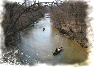
We floated from State Road 643 (Lewis Ford Road) to State Road 605 (Swinging Bridge Road), a distance of about 8 miles. The gauge reading at the Rt. 643 bridge was about 175 CFS, which was just about right for this section. Any less and you will be scraping and walking some sections.
The Put In is on River Left, on the east bank at Rt. 643. A 10 ft. bank requires a hand carry or slide, but rather easy to get to the river under the bridge. Private property, but it has been used before.
Although most of the land nearby if farm or timberland, there are little signs of civilization. There was one old campsite about a mile below the put in on Lewis Ford Road and a cabin on river right, about 1 mile above the take out on Swinging Bridge Road.
High bluffs hug the river on one side or both. Rhodadendren groves and several rock outcroppings overhang the river in places. Some deep holes, but mostly shallow, with a sandy bottom.
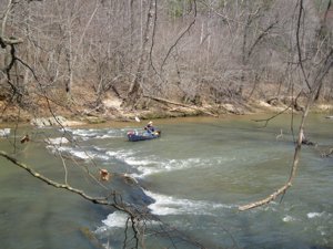 About 5 miles into the trip, on river left, at a rock ledge, looks like the old stone foundation of a mill or bridge. Good cobble bar below it for a stop.
Take out is on river right, at Rt 605, Swinging Bridge Road. Again, this is private property, but has been used for years as local access. Can park in the old road bed.
Accommodations:
none
Fees:
none
Resources:
Roger Corbett's book, "Virginia Whitewater" has a trip description with maps, mileages, and shuttle directions
Trip Details
- Trip Duration: Day Trip
- Sport/Activity: Kayaking, Canoeing
- Skill Level: Beginner
- Water Type: River/Creek (Up to Class II)