
Diascund Creek Reservoir in Virginia
Trip Overview
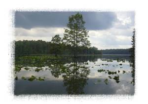
Diascund Creek Reservoir is located in the lowlands of the Chicahominy River basin on the Virginia Coastal Plain. A look at a map will show the reservoir consists of 5 long flooded creek valleys which join into a substantial main body where the boat landing is. Theres plenty of elbow room on the reservoirs 1,100 acres. The view from the boat landing is attractive but reveals just enough open water (1+ miles) to intimidate.
It was partly cloudy, with a predicted high in the mid 70s, and a light NW wind. Tropical Storm Ernesto had inundated the area only two days previously, so the water was high and cool. The creeks all drain from swamps which feed the lake with tannin-stained water carrying enough sediment to reduce the visibility to 6 inches. I was on the water shortly after sunrise to maximize wildlife viewing and reduce the chance of running into a late afternoon thunderstorm. It was nice not to have to plan my itinerary around the tides for once.
Summer turns off as if by a switch here, and there was a thin, cool fog on the water as I paddled into the eastern-most (Barnes Swamp) arm. The wooded shores are extensive with occasional private piers with homes that were usually obscured by the foliage. At this high water level, I was able to comfortably paddle close to shore.
I saw four wild turkeys in two groups barrel across the lake. They are reputed to be good fliers, but they must have been carrying a heavy payload of acorns because they struggled like feathered bowling balls. This arm of the lake also had many small painted turtles with particularly large and bright yellow ears.
 On one shoreline, I spotted the lonely tusked skull of a wild pig. As I stowed Wilbur in the tank well of my Prowler 13 SOT I thought, Evidently, I found what I was looking for. Later I found that Wilbur's adoption had cost me a few chiggers inside my neoprene booties, even after a thorough spraying with DEET before going ashore. Continuing up the arm, I eventually reached a low water bridge and turned around rather than continuing into Barnes Swamp.
Skipping a couple of large lake arms and many small ones (a thorough exploration would take days), I made my way back to the main body of the lake. Islands make this area quite interesting as well as a little confusing since they can hide the boat landing. A compass and a map would be helpful. Passing under the small Route 603 bridge into the central-west section, I was drawn to the roar of the dam spillway.
Beaching my kayak on the slippery rip-rap far from danger, I walked along the top of the dike to the spillway and watched the tea-colored water thunder down the 45 degree slope into the Chicahominy River 20 feet below. A common tern looked out of place in a small group of gulls on a concrete wall, possibly all refugees from the recent storm. I tested the dam hydraulic with a log: probably not a keeper. Nevertheless, this area has great potential for generating colorful language should a fishermans trolling motor battery die.
The section of the reservoir facing the dike has up to a 1 mile fetch, so if conditions are windy one might have to run a gauntlet before finding protected waters in these western arms. On this day there was only a modest headwind. I chose the largest arm for which the reservoir is named, Diascund Creek. Most of the reservoir shoreline consists of low, clay, rounded hills but in the western arm this gives way to even lower, often swampy shorelines of greater natural beauty and isolation.
 The wildlife viewing got better and better as I paddled up this arm. Large fish were constantly swirling around me in the shallows, sometimes spouting like mini-whales, sometimes leaping completely out of the water. A large paper hornets nest hung in a persimmon tree just above my head. The turtles were much larger and of diverse species, but extremely shy, usually tumbling off their basking logs when I was hundreds of feet away. In addition to the persimmons which had begun blushing yellow, fox grape vines with ripe purple fruit hung in the trees. I encountered belted kingfishers, a few stubby but attractive green herons, and the largest density of great blue herons Ive ever seen. I couldnt identify many of the small birds, but the yellow warbler was too gorgeous not to look up in a bird handbook.
The fishermen were all in this western arm. Given that it was Labor Day weekend and there were only 5 boat trailers in the entire parking lot of this electric-only reservoir, a weekday paddler might not have to share the lake. The one fishermen I talked to had caught what sounded like an inordinate number of bass; hopefully, he was releasing those over the limit. The scenery is quite breathtaking, but the trees in the area arent giants.
Id love to say I made it to the end of Diascund Creek and was stopped by an impenetrable swamp, but I never made it that far. The clouds had been slowly thickening all day long and were now glowering directly overhead, the wind was increasing, and I was an hour from the boat landing. On the way, I had noted too many trees along the waters edge with their tops blasted by lightning. As I paddled back to the landing, I passed two boats of mellow, trolling fishermen moving in the opposite direction more worried about missing a potential pickup in the bite.
Note that the reservoir isnt completely secluded. Youll occasionally come around a promising corner only to find a small group of homes with an above-ground pool and barking dog. There is a flock of domesticated geese in one location which make a racket that could wake the dead and cause them to flee, and when the leaves fall Im sure many more private homes will be visible. Like most reservoirs, the water level is drawn down in October before the winter wet, so some of the most beautiful upper swamp sections may be reduced to mud flats thereafter for months. Nevertheless, this is a paddle of significant local interest for those who are into wildlife watching, fishing, or nook exploration. The described trip was 13+ miles, but if you pick only one arm to explore it could make a nice 6 mile outing.
The nearby Little Creek Reservoir offers a somewhat different experience with clear water, a less swampy shoreline convenient for breaks, but a lower density of wildlife.
Accommodations:
No facilities at boat landing. Small store nearby on Rt. 60. This destination is primarily of local interest, but there are plenty of hotel rooms in the Richmond or Newport News, VA area only 30 minutes away.
Fees:
No fees
Directions:
Located midway between Richmond and Newport News. Once in James City County near Lanexa, Virginia, take Interstate 64 to Route 60 and follow the signs to the no-services boat landing on the southern shore.
Resources:
ADC road map for Greater Hampton Roads will get you there.
Free aerial photos and topo maps from http://www.terraserver.microsoft.com were useful for trip planning.
Trip Details
- Trip Duration: Day Trip
- Sport/Activity: Kayaking, Canoeing
- Skill Level: Intermediate
- Water Type: Flat/Sheltered Water