
Corpus Christi Area in Texas
Trip Overview
 Corpus Christi offers fantastic year-around paddling. First of all, weather is almost always sunny and warm (for Feb thru Nov, average maximum high temp is 70 to 94, average maximum low temp from 51 to 75). Even Dec-Jan the range is from 47 to 69. Secondly, there is a great diversity of paddling, from Corpus Christi Bay at the edge of the city and marina, to Laguna Madre for great birding (protected waterways between barrier islands and Texas coast), the Gulf where you can drive/camp on the beach and paddle in the surf, to remote rivers (Aransas, Nueces), and Lake Corpus Christi. In many areas, you can paddle all day and not see another person, but see lots of birds, deer, wild hogs, and alligators. No matter what direction the wind, you can always find a protected area to paddle, or you can surf the waves.
Here 15 easy day-trips. If anyone is interested in kayaking Corpus Christi, I would be glad to show you around and get you started. Send me email johnson@earthlink.net
1.Laguna Madre with calm shallow water area, protected from east/west winds. Launch from Padre Island side of SPID bridge to Padre Island (firm sand and clear water launch) and paddle around bird nesting areas, shrimp boats, small marina, waterfront homes along Padre Island on the Laguna side. Or paddle south on the Intra-coastal Waterway (which will have sailboats, powerboats, and possibly a tug and barge), across the Laguna Madre to explore the King Ranch, and then stop at Snoopie's or Frenchies for waterfront drinks/dinner before taking out kayaks at SPID bridge. 6 to 20 miles depending upon course.
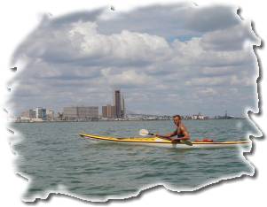
2.Emerald Cove and City Bayfront with shallow water launch on sandy beach in front of Holiday Inn on Emerald Cove. Protected from north/south winds. Paddle north past city bayfront and yacht basin, past Bayfront Plaza, by the Bay Bridge, past the Aquarium, around Lexington Aircraft Carrier, northeast along Corpus Christi beach by beachfront condominiums to Portland Bridge, and back across the bay (good chance of dolphins). See city skyline and yacht harbor from the water, bird nesting islands, and beachfront. Good chance of seeing sailboats, powerboats, and ocean tankers/freighters in the channel to Corpus Christi harbor. 10-20 miles depending on course.
3.Cole Park to Corpus Christi University. Launch at Cole Park on sandy beach protected from south/west winds. Paddle southeast along beautiful homes along Shoreline Drive, past waterfront Condominiums, to University and back. 12 to 30 miles depending upon course.
4.Portland-Ingleside. Launch from Portland (15 miles from CC) on firm sandy beach, protected from north/east winds. Paddle southeast by Ingleside marina, around Ingleside Naval Shipyard, explore islands in Redfish Bay, return by Gulf Oilrig Repair Yard. 15 miles paddle.
5.Rockport-Fulton. Launch from Rockport Marina (40 miles from CC) on sandy beach protected from north/west winds. Paddle northeast by Rockport marina and beaches, beautiful waterfront homes, into Fulton Shrimp Boat harbor, and have lunch at restaurant on the bay. 12 mile paddle.
 6.Aransas River. Launch from Bayside-Woodsboro road (40 miles from CC) on calm riverwater protected from all winds. Paddle north or south for good view of isolated refuge birds, alligators, deer, and wild pigs. 10-20 miles paddle.
7.Shamrock Cove on Padre Island. Launch from Wilson Cut (30 miles from CC) on muddy landing but calm protected waters, and paddle past remote bird-nesting islands. Best birding area. 10 mile paddle.
8.Aransas National Wildlife Refuge Whooping Crane Tour. Launch from Live Oak Point at bridge across Copano Bay (45 miles from CC) and paddle in Intracoastal Waterway between Matagorda Island and Aransas Wildlife Refuge to Mustang Lake. 30 mile paddle. Only 12 mile paddle if only paddle northeast to Goose Island, Blackjack Point, and Bird Point.
9.Port O'Connor Matagorda Island State Park. Launch at Port O'Connor (80 miles from CC) and paddle southwest past various bird-nesting islands to Matagorda Island State Park (only reached by boat). 15 mile paddle each way. Can camp overnight on Matagorda Island which is deserted (only airstrip remains from when it was an Air Station).
10.Copano Bay. Launch from Live Oak Point at bridge across Copano Bay (45 miles from CC) in protected waters. Paddle north under bridge, past Redfish Point, Newcomb Point, to Palmeto Point. Return via Goose Island State Park. 12-mile paddle.
11.Bird Island Basin. Launch at Bird Island Basin on Padre Island National Seashore (33 miles from CC) and paddle 6 miles to Green Hill sand dunes. Isolated area for birds, cayotes (and rattlers) with beautiful isolated dunes and beach. Protected shallow water. 12 mile paddle each way (can camp overnight).
12.Seadrift Guadalupe Bay. Launch at Seadrift (65 miles from CC) and paddle northwest in protected waters to see alligators and natural wildlife. 10 mile paddle.
13.Nueces river. Launch at Nueces State Park (20 miles north of CC) in protected waters. Paddle north for quiet isolated bird watching in heavily wooded areas on both sides of river.
14.Lake Corpus Christi. Launch at Lakeside (40 miles northwest of CC). 10 mile paddle. Nice homes along lake, wooded.
15.Gulf beaches on Padre Island. Can drive 8 miles on the beach and if waves are under 4-feet, can surf the waves on the beach or paddle out in the Gulf.
Accommodations:
Many hotels/motels in the city, some right on the beach and water (Holiday Inn, Raddison). Free camping on the Padre Island Gulf beach, and at the tip of North Beach in Corpus Christi.
Fees:
There are not any fees or permits required. There is a free protected public boat launch ramp right downtown on the southernmost city pier that is closest to the Holiday Inn on Shoreline Drive. Public city beaches (McGee Beach downtown on Shoreline Drive between boat launch and Holiday Inn), North Beach across the bridge from Corpus Christi where the aircraft carrier USS Lexington is moored, and the Gulf beaches on Padre Island (30 miles south of Corpus Christi on South Padre Island Drive (SPID), all provide free places to launch your kayak.
Directions:
Corpus Christi is on the Texas Gulf of Mexico coast, about 200 miles north of the Mexican boarder, and 200 miles south of Houston. You can reach Corpus Christi driving south from Houston on Texas Highway 59, 77, 37; driving 140 miles southeast from San Antonio on Texas Highway 37, driving north from the Mexican boarder at Brownsville on Texas Highway 77 and 44. One of the pleasures of Corpus Christi is that there is never any "big city" traffic.
Contact:
My website has 3 pages with 19 pictures of places to paddle in Corpus Christi, with links to the Chamber of Commerce "things to do and places to stay in Corpus Christi). Check out... http://home.earthlink.net/~johnsonkw/
Resources:
There is a great Chamber of Commerce "Tourist Information" building right on Shore Line Drive that runs along the city waterfront. They have many booklets and pamphlets on things to see and do in Corpus Christi.
Trip Details
- Sport/Activity: Kayaking
- Skill Level: Beginner
- Water Type: River/Creek (Up to Class II)