
Clayoquot Sound in British Columbia
Trip Overview
 The change is subtle. One moment the world is all shades of black and then blueness registers on my brain. The light grows and the faster colors escape from the dawn's slowly opening vault of colors. The high clouds become pink tinged bands of gray and then glow brighter with reds and golds. Frames of film go quickly as I shoot morning sea and sky at Ahous Bay. A final frame after the brightest colors have fled and I am done. Into the bag with the camera and I'm off to grab a cup of coffee from the thermos.
This is my time. I love to be there when each day kisses the world awake. My somewhat cynical subconscious echoes back, "Your at-one-with-the-earth attitude might be a little less reverential without coffee" Which is true. I raise my cup for another sip and movement at the shoreline catches my eye. A moving shadow no, two! Wolves! Casually padding silhouettes against the dawn reflecting sea, they pace unhurriedly along the beach in front of our camp. I give a low whistle to let them know we're here then immediately think, "Silly. They knew we were here long before I saw them."
The leader, slightly larger, gives no sign of interest and continues patrolling the surf line, his pace unchanged. The second, smaller animal pauses, looking my way, then turns back, moving in hesitant scurries towards cover in the big drift logs a hundred yards up the beach. The larger wolf quickly fades into the wooded shadows on the point south of camp. Up the beach to the north, occasional low howls become ever more distant for a while, then come no more. I regret separating them. I also regret not having a camera out and ready.
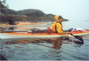
Normally my wife Connie and I paddle to our own trip plans, but this year a badly damaged shoulder (bike race) keeps her off the water. We've done long expeditions on inside passage waters, and have dealt with squirrelly water occasionally, but have not paddled on the open sea. This led me to seek the company of a guided tour both for safety and to learn about surf from experienced guides.
 The desire for new waters and company brought me to Tofino, the entrance to Clayoquot Sound on the West coast of Vancouver Island. I registered early for a tour with the Tofino Sea Kayak Company that will take seven of us on a five-day tour of Clayoquot Sound. Our guides, Doug Wright and Kristi McMillan, are young but mature, knowledgeable but not overbearing, experienced kayakers and certified guides. A plus for our group is that Doug has trained as a chef! One would lead and set the path and pace while the other moved around the pack, encouraging, giving hints and keeping tabs on the less experienced paddlers.
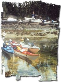
In mid morning, after our last on-the-beach instructions, our group of two double and five single kayaks nurses itself away from Tofino. A high overcast warms the day slowly while we find our wings, and our progress is leisurely as Doug and Kristi gently try to keep us all in the same province. The sun is high and peeking through the high haze as Doug leads us through offshore rocks to a pretty cove on Vargas Island for a lunch break. On a stack of giant storm deposited logs our lunch buffet unfolds to give us a hint of the meals to come. Freshly baked breads, cheeses, snacks and spreads of spicy variety assail our sense of smell and taste. The silence, sunlight and sparkling sea add magic to Doug's description of this cove as a "back-door" getaway route for the early First Nations tribe that used to camp across this neck of land.
We launch and wind through the rock-filled and protected waters at the southwest corner of Flores Island and soon cross trails with an acquaintance of Doug's, another guide by the conversation. With the ocean breaking over rocks on our left, we sit atop the water while holding a short conversation with a person standing shin-deep in the water. I am struck by the casual ease of the situation and love that Sea Kayaking has such a unique, flexible and non-threatening character.
My adrenalin level rises as we near Ahous Bay. Respectable waves are breaking on the far shore. But we turn a corner and approach the south end of the beach where there is MUCH less break. Kristi gives us simple instructions: If the onshore guide's paddle is vertical, go hard for the beach. When it's turned horizontal, back paddle. Kristi goes ashore first while Doug tends the pack outside the break. One by one we stop-and-go our way to the beach. The mild break and Kristi quickly hauling us up to more stable sand helps keep us dry. But I manage to wrap my paddle leash around me while trying to get out of my boat, so at one fell swoop I learn two lessons: How to surf land and how not to surf land Stow the paddle leash offshore.
After the tents are up, my tent-mate Rick Shypitka, a semi-retired actuary from the Vancouver BC area, takes off for a beach run. He returns with an six-inch tall Bolete mushroom that looks like a plump Disney elf. We crowd around the field guides while Rick identifies the mushroom. It sure LOOKS like the picture, but Doug isn't absolutely sure, so it doesn't go into the pot that night. I couldn't eat a Disney elf anyway
After sundown Dan Knight and his wife Elizabeth take over. Astronomers from Seattle, they walk a group down the beach away from the fire to tell stories about the sky. For me, the price of early mornings is early bedtimes so I turn in savoring the luxury of soft sand beneath the tent.
In the morning a few people have heard the wolf howls. After I relate my tale, a group takes off in search of tracks. They return quickly when the breakfast aroma signals them. Time makes me forget the meal, but I remember the mastery. Whatever it was, I sure enjoyed it!
 Repacking the boats seems impossible. What pounds we've lost in food consumed we've regained in sand, plus some. Nothing seems to fit into the hatches as well today. We reverse yesterday's landing order to launch, an easy job from this lightly tide caressed beach, and strike off toward the north. Clouds soon overtake the morning hues and a light mist begins as we stroke towards our lunch stop at the Whaler Islets. The temperature is mild and there's no appreciable wind and as a paddling group we feel more together this morning. Large offshore islands keep the swell mild and the paddling is easy.
Our lunchtime target is the largest of the Whaler Islets. A dumbbell shaped spit of sand with a crest of knee high beach vegetation running across the handle. The low vegetation rises to small stands of Cedar and Fir desperately clinging to the higher rocks on each end. A bright yellow tent half hidden in a protective grove on one end gives high contrast to the muted grays and greens of an overcast northwest day. What a cool campsite, I think. We scout the dumping surf on the north side and decide to land in gentler small swells on the south side. No paddle leashes tie me to the cockpit this time. Lunch gear is convoyed across the spit to the leeward side of the crest where we huddle under a few trees overhanging a bank. We venture out to explore tide pools then scurrying back for hot cocoa and cover. Raingear helps us tolerate the mist and breeze, but kayak cockpits are warmer. Lunch is quickly over.
The mist eases and the sky lightens as we approach our next camp at Whitesand Cove. The Gibson Marine Park has roughly a mile and a half of sand beach on Whitesand Cove, at the southern end of Flores Island. A nose of land that reaches towards some small islands just offshore splits the curve of the cove's beach into two curves. Kristi and Doug opt for a site just east of that prominence. A wise choice as it turns out.
Landings are the easiest part of beaching for me. Hauling the fully laden kayaks the hardest. After we're all onshore we gather like pallbearers around the double kayaks and on command from the stern carrier, hoist and haul like a maddened millipede, legs churning the sand for traction that doesn't exist and unencumbered arms flailing at the air until we're safely beyond the potential tide line. Even the single kayaks need four people to move while loaded. Advice: avoid wide beaches!
There's plenty of daylight remaining to setup camp so we completely unload the boats, carrying tents and personal gear to our selected turf and gathering the kitchen gear and cold-bags in what will be our campsite community center. Like building a house, we first see to our individual bedrooms, then we communally decide where to place the stove, the fireplace, the dinner table and the kitchen sink. The OTHER room of the house is "down the beach, that-a-way" we're told.
"That-a-way" turns out to be roughly a quarter mile east of our camp where there's a recently constructed cedar outhouse hidden in a grove just above the beach. With as many people using this beach as do, an outhouse is a relief in more ways than one.
The mists return, threatening to grow, so spare paddles are sunk in the sand to support tarps and we roof our "long house" in yellow nylon. It isn't esthetic, but is effective. Uh-oh! Disaster! Our camp stove has leaked and is out of fuel. We gather dry cedar cuttings from up the beach and haul out a camp axe to batter a dry cedar chunk into small enough pieces to make a cooking fire. Doug and Kristi perform their magic rites over the open fire and dinner under the "eaves" becomes a bouquet of garden delights spiced with piquant sauces, herbs and peppers. In the failing evening light the KP squad for the evening does its job at the intertidal kitchen sink.
After the dishes are done John Bender, a good-natured attorney from Vashon Island produces a dash of brandy to cap off the evening. Dan produces a harmonica and blows a couple of mean blues riffs to warm up the after dinner social hour.
 In the morning, after my obligatory half-mile trudge, my bare feet complain about the sanding they are getting. Sand under sandal straps won't do me any good either, so I venture to try what my wife suggested a year ago, polypro socks and sandals. Carefully drying and cleaning my feet after an early morning wash, I slip on the combination and then face an ethical dilemma: when I get home, should I tell her that I finally took her advice? Maybe not...
No wolves or colorful sunrises this morning. As light seeping under the clouds changes my phantom bears into stumps and bushes, I sip my morning brew and watch the world awaken. Unencumbered with current events, my mind roves through time, creating its own history and future, my personal storyteller
After a hot breakfast burrito we're just about ready to mount our steeds for a day trip exploration, when a troupe of men and dogs approaches down the beach. They are first nations people engaged in creating a trail for hikers around the island. They also search for and identify cultural markers in the Cedar forest. Culturally modified trees are archaeological finds, telling us things we have forgotten about the time, technology and people who inhabited this region for thousands of years before the arrival of my immigrant forefathers.
Hailing adieus we launch into a brightening morning. The day is warm and the sea calm. We paddle beyond the protection of near shore rocks into a zone more open to the sea. Our guides watch closely for signs of nausea as the swell increases noticeable. Ahead waves explode impressively on a low rocky barrier off a point. We glide past the outside of this break close and simply bob up and down like corks as the surge passes beneath us. This helps me capture and hold the concept of wave and water as separate elements. Linked but not locked. We curl around the end of the rock shelf and our path curves back in front of the break now into a kelp clogged channel of calm. The narrow gap in the kelp presses us into single file, but the wave has spent its force here and the water rises and falls only mildly. Another turn and we glide on quiet water between sentinels of barnacled and beaten rock on both sides. Turn again and we are upon the beach. There is no need for surf landing disciplines. The water rises and falls gently on a wide sandy beach. Lunch gear is almost all we carry today, so bringing the boats off the water is an easy chore, quickly done.
The map shows a creek at Cow Bay where we might find fresh water. The creek is easy to find, we've landed at its outflow. But its sluggish here and bracken for some distance. John treks down the beach, empty water bags in hand, optimistically looking for a creek-crossing trail further down. Others don swimsuits to take advantage of the body and hair-washing opportunity. The day clears even more and the sun caresses us with September warmth. In awhile John comes wading down the creek bearing his trophy water bags, but the water is still too bracken to drink. We keep it anyway for different wash tasks. Lunch is laid out in shining bowls along a log like a strand of silvery half pearls. I nap in the shade to avoid losing my northwest pallor to the fickle sun, some splash and laugh in the creek and still others nap in the sunshine. Life is indeed excellent!
We paddle leisurely back to our camp in the early afternoon. A few stay afloat to match wits with the wily Salmon. They lose. Onshore we need to deal with the real world. A group of five or six begin the walk into town, a couple of miles northeast of our beach. Their mission: get gas! The radio threatens an ominous storm from the West and clouds begin to gather. The day has become typically northwestern, with occasional dampening and continual threat.
An additional tarp enlarges the communal space as we try to make more room under cover. The work crew we met in the morning has left us a few cedar chunks from their trailblazing efforts and someone begins slicing cedar shavings to start a fire. While I appreciate basic survival skills, with rain falling and the day cooling I go for the fire starter nuggets and soon we're playing dodge the smoke over logs and around ropes and paddles supporting the tarps. The group that walked to town returns triumphant with a single gas bottle, swearing up and down that not one of them had ice cream
Dinner is excellent as usual but our attention is on the weather. Sudden gusts snatch the tarps first up, then down. We cluster close around the fire as the wind clutches and moans in the treetops. I feel the presence of all my ancestors who gathered thus at the end of their day. A feeling that is broadly shared tonight.
 Our guides have sited the camp wisely. The nose of treed land, jutting into the bay on our western side protects us from the most direct winds. But the night passes fitfully. Rainsqualls hammer the tent with a mad intensity at times, dragging me wary of something from the depths of sleep. Mind games. Back to sleep The squalls diminish before I awake, quieting the world. I try to slip quietly from the tent to avoid waking Rick, but the tent foyer is a mess of wet sand and soggy socks. Placing things carefully the night before helps some, but I've kicked my carefully piled clothes around during the night and have to dig in a bag for dry socks. Rick doesn't complain so he's either very tired or very considerate. I suspect the later.
Darkness hangs on the world longer this morning and peering out from under the tarps feels like I'm looking at the workd from a WWII bunker. I'm concerned about trying to paddle in the wind and waves today. The dawn opens a show of dancing whitecaps and still heavily gusting winds. Our protected campsite seems a fine place to stay. At breakfast we agree to wait out the weather. If necessary we can radio Tofino for a powerboat pickup. By afternoon the winds are still high, but the clouds scuttling overhead give way to larger and larger patches of blue. Whitecaps still dance on the channel in front of us, but fewer in number. It's the kind of day where you put your raingear on, then fifteen minutes later you take if off again.
The group needs to get out, so a bunch embarks on an expedition up the new trail looking for "Culturally Modified Trees". But Cedars that haven't been worked for bark strips or dugout carving for over 150 years can be difficult to spot. They return after a short time and divert their unused energies to a game of beach Frisbee. Dan, Elizabeth and their friend Kate Grossman, a youth counselor from Camano Island, are pros at Frisbee. At half my weight, Kate can hurl the disk accurately twice as far as I. It is Kate's first kayaking trip also and while she seemed tentative at first, has become more comfortable with time and exposure. The beach-bound day winds down with the question of how we'll get back to Tofino still unsettled. Morning will be a time for decisions.
Radio reports in the morning are promising and the sky shows clear. Doug feels that even though the water isn't mirror smooth, we should be able to paddle back without problems. To catch the right tides we hasten to roll up camp. Launching to the southeast we catch the late flood into Calmus passage, then hold close inshore to the whiskers of the Catface range across the Coomes bank. Our route winds past rocks and idyllic coves, some with cabins. Doug tells us that many of these protected coves were traded to people who had homes along the beach between the towns of Tofino and Ucluelets to establish the Pacific Rim National Park. Seems a lot more reasonable than just applying eminent domain and tossing people out. The wind waves are favorable and we try to surf a few for the joy of it.
We cross behind Morfee Island, riding the early ebb towards the inland side of Vargas Island. Rounding a corner into Maurus Channel Doug leads us into a protected backwater beach for another buffet lunch. We oblige by trying to empty all the remaining servings of goodies. Our last meal together for the whole group, it is a time for pictures and anticipation of the end. I mull over this launch being our last. But my full attention is drawn to the immediate as we round into Father Charles Channel. Afternoon winds have risen from the southwest opposing the ebb tide. Our group does well, but the crests are three feet high on our beam and holding a different course than the troughs allow becomes a continuous battle.
In less than a blink, my boat is on its side at the top of a crest. Uh-oh, I'm going over. My paddle desperately tries to seek the water on my right, but it's a LONG, LONG way down. Knee jerk! Knee jerk! BANG! My paddle handle hits the cowling finally. Whew! I'm still upright?! No time to reflect on the miracle, as the next crest rises under my boat. Keep paddling. "Nice brace." Comes from Doug, behind me. "Brace hell!" I'm thinking, "more like panic." I've been dumped atop a wave like that before, fortunately while practicing in a protected bay. That time I didn't have the knee jerk. This time it saved my bacon. Beware the last mile!
A hundred yards from shore, Kate digs into a pocket to retrieve something and her car keys go spiraling down to the unseen bottom of the bay. She's driving for three people Beware the last mile!
Landing is not the end of the trip. There's plenty of work remaining to separate gear, clean it and stow it then clean and store the boats. Everybody participates and the job is soon done. After a quick latte and address swaps our paths diverge. In the moments that my car engine warms up I hesitate. I feel the camaraderie, the people and the area pulling at me, urging me to stay. I understand how so many people came to visit and became natives. I cherish that I will always have this place, these people with me evermore, but my home beckons more strongly.
Outfitting:
Outfitting provided by Tofino Sea Kayaking Company.Equipment: Me-Seaward Quest;Doug-Current Designs Expedition; Kristi-Montauk; two Seaward Southwinds, and two other singles.
Directions:
Vancouver Island Highway 1 North from Victoria or Nainaimo to Parksville, Highway 4 West to Tofino.Resources:
Canadian Hydrographic Service #3673 (The chart index has changed since I purchased this item.)Trip Details
- Trip Duration: Extended Trip
- Skill Level: Intermediate
- Water Type: Open Water/Ocean