
Carry Falls Reservoir in New York
Trip Overview
Carry Falls Reservoir, Northwest Adirondacks, NY
July 9 15, 2006
OC1 - Mike, Diane, Tyler, Cooper
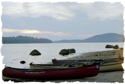
With four canoes gunwales down and rock solid secure on the new quadruple crossbar Quick and Easy van racks (the design concept works well, although it necessitates some macramweaving of belly lines, and I can comfortably put off buying a BMO trailer for another year or two. Or until I learn how to back up a trailer with muttering invective, whichever comes last) we motored 8 hours north from the Mason Dixon Line aimed for the Adirondacks
Headed north with a familiar routine; we had our initial destination thoroughly plotted and planned, full topo coverage, gear drybagged and food for 4 or 5 days. In the van we had a surplus of drygoods, clean clothes and spare reading material to last us another week. And a thick map and info file of possibilities for the second half of the week elsewhere in the Adirondacks; Bog River, Lows Lake, Lila and a half dozen others.
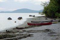
We chose Carry Falls as our first destination because, other than having not yet been there, it is a large (3100+ acre), shallow (average 18 depth, max 50) dam controlled lake reputed to be fringed with sandy beaches at summer pool levels. It is also oriented north/south and less likely to blow up a whitecapped chop than the north east-west Lows, Lila or Tuppers.
We were, after a fashion, wrong on both counts. The winds over the course of the week were predominately from the south, or the north, and putting on we recognized that the reservoir level was only a foot or two below maximum pool level.
 After loading a veritable mountain of gear (it is absolutely amazing the quantity of gear that 4 solo canoes will swallow how in the world did we ever do this in a 16 tandem and a 15 tandem?) we headed north past a sparse scattering of cabins along the east bank.
Passing the mouth of the Jordan and a few more cabins we curved east along the shoreline, past a jeep/ATV trail that parallels the Jordan and on to our intended destination at Maple Island.
Occupied. Two motor boats, the only other folks we had seen on the lake thus far, were ensconced on the Maple Island beach. Apparently picnicking, but it was hard to tell.
Not wishing to intrude on their idyll we scouted out the two small islands east and north of Maple. Nothing doing on the north island, a bit more favorable camping on the east island and scouted the embayed shoreline at the mouths of Cold Brook and Little Cold Brook. Nada much at high water levels.
Intrusive or not, I paddled over to the party on Maple Island and, chatting them up, discovered that they were in fact picnicking on the beach and was graciously invited ashore to make camp. I prophetically remarked to them that I would likely remember only their dogs name. Doofey, a large, black, mixed breed of friendly and seemingly intelligent disposition.
Possibly more intelligent that his human companions; while Doofy appeared to be a leave-no-trace ethic canine his two-legged companions deposited a variety of toilet paper "flowers", beer cans and two-pack-a-day-habit cigarette butts crushed in the sand.
We traditionally leave any site cleaner than we first found it, but Maple Island may have set the benchmark for policing the area. Over the course of our stay we collected a caseworth of empty beer cans (and two full ones alas they were Bud Light), picked up a carton of cigarette butts, cleaned up a couple of debris-laden firepits and properly disposed of the unsightly deposits of numerous folks who desperately need to read How to shit in the woods.
I could sarcastically ascribe this scattered litter to the remnants of a past NPMB rendezvous, but that absurd accusation has already been coveredand there were no empty Bud cans denoting the presence of DougD. (Just kidding, inside joke for old NPMBers).
The heavy-use aspect of the Maple Island campsite is understandable it is probably the premier site on the lake, and rates a solid 90% on the McCrea Family site grading scale, with the highest scores possible for sun/shade mix, landing ease, tent space, swimmability and water views losing points only for wanderability (it is, after all, a small island) and bugginess. If there were points awarded for hanging nails in trees it would be an A+.
And the bugginess may have been as bad or worse anywhere else. The high mid-summer pool level evidenced the aftermath of a recent moist stationary front, no doubt contributing to a dusk mosquito population and an abundance of flies (many of whom fell victim to my forked stick and duct tape fly swatter).
I was impressed with Diane and the boys ability to tolerate the insect population. Unfortunately all too well experienced at camping with bugs, they were quickly inured of annoyance and we never resorted to headnets and rarely to socks, pants or long sleeves.
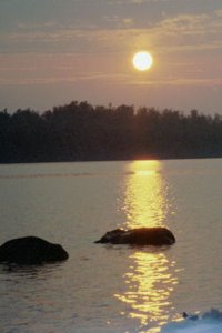 It helped immeasurably that the Maple Island site features excellent sand-bottomed swimming, and a wrap around beach that offers not only sunrise and sunset views but also multiple choices for bug-lessening windward sides.
That wraparound white sand beach continued to wrap around increasingly further over the course of our stay, as the dam release water dropped the pool level further each day. We marked and re-marked the pool level several times a day with stones placed at the waters edge, estimating that it dropped at least 2 feet over the course of a week.
What does a family of four do for a week on a small island?
Swim; as usual on lake trips we brought two inflatable rafts, cheap Colemans that have surprisingly lasted nearly a decade of hard use (thank you Mike Yates). Just hope the wind blows you into an eddy when you nod off while afloating.
Read; we brought multiple books, and traded off when finished. Side note to Doc, CWDH, Brian and others who enjoy a good tale of exploration and adventure: "Off The Map", subtitled "Tales of Endurance and Exploration" by Fergus Fleming comes highly recommended. Forty five chapter ranging from the familiar Magellan, Hudson, Franklin and Admunsen/Scott to the more obscure Ibn Battuta, Clapperton/Lander, John & James Ross and Umberto Nobile. A fine read.
Swim some more.
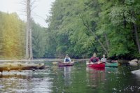
Day paddle. We had a couple of high wind days but none the less explored the Jordan River, Cold Brook and Little Cold Brook and most of the eastern shore. With a steady wind from the south the isthmus due north of Maple Island collected bits of breeze blown flotsam from the reservoir, including a pack of hand-tied hooks and a couple of lures.
The south shore of that isthmus has another fine beach even at high water, and a small, grassy camp clearing just at the treeline big enough for a tent or two. Buggy though.
I was not the only one who appreciated the flotsam gathering along the south shore of this isthmus, and the beach was covered with bear tracks and occasional bit of fish fin and scale, a wind-delivered ursine smorgasbord. Buggy and beary. On the whole I would rather police the empty beer cans on Maple Island.
Swim some more.
Play games. The usual all-terrain bocce, using old croquet balls and golf balls. Skee ball; Diane made a skee-ball ramp up one steep dune. And miniature golf.
That last provided hours of course-making reminiscent of a past trip that featured several days of windbound leprechaun house construction. Cooper proved the master of creating miniatures golf holes, including dogleg bank shots, water hazards, ramps and other tricky obstacles. Although Diane holds the 9-hole course record, but only thanks to Coopers damnable bonus shot design on the 9th hole. I will note that in the midst of an earlier game "Tiger" Hollingsworth had hurled her putter into the lake. And later burned it.
Swim some more.
Go bowling. Yet another bocce ball beach game. A sand alley and a pin rack of beer cans, including the two full Bud Lights at the seven and ten spots (finally a use for Budweiser products, although they made it tough to pick up the spare). Word of warning: Dianes thrown object release problems extend to beach bowling. Stand clear or wear a helmet.
Eat. Yeah, we do eat well on trips. Aside from separate food and drink coolers and a bread bucket we were toting a 60-litre barrel and harness stuffed to the brim. Filet Mignon with a shallot, tarragon, onion and garlic Brnaise sauce. Roasted rack of lamb with white wine and garlic sauce. Smoked salmon and mozzarella ravioli with balsamic vinaigrette dressing. Sea Scallops in chili hollandaise. Lemon grass grilled shrimp.
OK, ok truth to tell we had hooked up with a rep from Grog and Gruel to try out some of their flash frozen boil-in-bag meals designed for sailboat racers. On the downside these meals require refrigeration and create a lot of plastic packaging trash, but preparation was boiling water simple, the food was astoundingly good (and the sauces terrific) and they can ship anything from their extensive menu anywhere in the world. No ramen noodles this trip!
Swim some more. And marvel at the near total absence of power or paddle boats on the reservoir. With the exception of the Doofy family and a few puttering fishermen the lake was routinely devoid of other people and we would continually walk out to the expansive water views on the beach and marvel, "Theres no one here."
Run around the island. Cooper laid out a cross country course circumnavigating the island, sometime in the shallows, sometimes overland, over and under fallen trees and other hazards. The course record is 2:14. Unless you are an agile 119 lb wrestler/gymnast you wont come close.
As the reservoir levels continued to drop more and more sandy beaches were exposed, both on Maple Island, which at very shallow water apparently connects to a nearby peninsula on the east bank; the underwater sandbar between the two is nearly wadable even at high water, and elsewhere around the perimeter of the lake. The lowering pool level opened up abundance of sandy beach camping areas and by Friday we had company on the lake in the form of a boat of carousing twenty-somethings ferrying friends over from the dam launch.
There are a lot worse things they could have been up to than camping and carousing in the woods, although I was tempted to ask them to change the station on their boombox after an evening of Styx, Journey and glam rock oldies. Or paddle over to see if they had anything better than Genny Red why isnt there good pale ale in cans?
Time for another swim.
 Sit around the campfire. There is an abundance of dead and downed wood on the island and more as driftwood piled around the outskirts beaches, perhaps demonstrating that it is more of a day use picnic destination than a heavily used campsite. We had largish Whiteman fires every night, either up in camp or down on the beach (in due course cleaning up and consolidating multiple firepits in both locations) and twiggy breakfast fires each morning. How did we ever survive the evening munchies without pie irons in the coals?
Swim a little more. Did I mention that we spend a LOT of time swimming? Tyler especially, who accused the rest of his family of not liking the water just because we didnt spend 10 hours a day submerged.
So much did we enjoy the empty environs of Carry Falls and our site on Maple Island that we nixed the plan to move along and explore elsewhere, paddled back to the Parameter launch to re-suppy with ice at the Sevey Corners store*, grab some planned-ahead Guinness and Genesee Red stashed under the back seat and stayed for the rest of the week.
* The well water at the Sevey Corners store is potable, but not very tasty. And the water supply at the Parameter site is signed "Not for drinking". Bring a filter or pack it in.
After a couple more warm sunny days and cool nights (I love wearing July fleece in the Adirondacks, and hate coming home to a bank clock flashing "8:30pm 29c 85f humid as Gods left armpit"), swimming, games and day paddles we broke camp on Saturday morning.
Two Alpine Meadows tents, one Hennessy hammock, one Travel hammock, one roll-a-table, one NRS River Wing, one 60-litre barrel and an Everest of drybags. Packed and into the boats in under an hour. With coffee breaks.
Paddle back to the Parameter launch, another leisurely hour. Van packed, boats racked and on the road, under an hour. All at a relatively leisurely pace. Since the boys have done this all their lives we are quietly efficient, having a cumulative 80 years experience between us.
Since we were packing out a considerable amount of trash collected from the Maple Island understory, we felt it was permissible to leave a few things behind. There are two golf balls and four hand-hewn putters on the beach beside the miniature golf course.
And a very effective flyswatter hanging in camp.
Have fun.
More photos archived on Community webshots: http://community.webshots.com/album/552466998aNBmeA
Outfitting:
Solo canoes
Fees:
None
Directions:
Northeast of Cranberry Lake find the intersection of Rte 3 and Rte 56 (Sevey Corners). Heading north from this point on Rte 56 there are multiple launch sites. Heading north from on 56 from Sevey Corners:
- 2.4 miles north on Rte 56 is an unmarked short but rough dirt road leading to Raquette River access just below Jamestown Falls. Not recommended for in-season overnight parking due to limited parking space (and questionable security?) this access does offer a couple of scenic flatwater miles of the lower Raquette and a nice view of the falls as inducement.
Probably a better day-paddling put in. - 4 miles north of the 3/56 intersection a paved right turn leads to the signposted Parameter campground. If you are arriving late this offers the option of pitching an overnight camp prior to an early put in. Ample secure overnight+ parking at the launch. A shallow beach beside the boat ramp offers an out of the way staging area.
- 12 miles up Rte 56 a right turn towards (signposted) Joe Indian Pond. Turn right after 1.5 miles to Carry Falls Reservoir and right again to a large boat launch/parking area at the north end of the reservoir.
- There is an additional dirt road access about a mile north of the Parameter launch, although from a paddling-past-lake-view this appears to have limited parking, lots of stored motor boats and may be private.
Resources:
Topographic Coverage: The Carry Falls Reservoir NY topo covers 95% of the reservoir.
The Stark topo covers the remainder to the west, including the downstream Stark Falls Reservoir and Black Falls Reservoir.
The Childwold topo takes in the southern tip of Carry Falls and the Raquette River upstream east to Smith Island.
Trip Details
- Trip Duration: Extended Trip
- Sport/Activity: Canoeing
- Skill Level: Beginner
- Water Type: Flat/Sheltered Water