
Calusa Blueway in Florida
Trip Overview
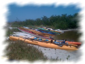
The Great Calusa Blueway is a series of paddling trails in the coastal areas and rivers of the Southwest Florida area, Lee County and Fort Myers. The trail is not linear. It is numbered and as far as I can tell, the numbers are essentially random. Anyway, I visited the area recently for 3 days of paddling and exploring. Truth be said, this is an area particularly blessed with fabulous paddling trails, especially if you like the open water variety.
Estero River to Mound Key:
This stretch of river is pretty, not spectacular. This is a very easy paddle starting from the boat ramp at Koreshan State Recreational area. Paddle west about 2 miles to marker 27. At this point, you have the option of paddling either of two sections of the river, either north west or southwest. Both legs end up in Estero Bay. We took the southern route, about an additional mile to Estero Bay.
Estero Bay is very nice, well worth the slog through the river. From the mouth of the river, which is marked with channel markers, look west for a trail marker. You will need good eyesight. Paddle to the marker, #25. This is Mound Key. You can paddle either way around the island to one of 2 sandy beaches where you can land. Look closely and go slow. These are small landings and easy to miss. The landing on the southeast side is in a small cove which is nice for swimming. Be sure and take the time to walk the trails on the Mound. There are lots of critters to see and the shell mounds make for a challenging walk. There are reports of domestic goats on the island, however we did not see any of them.
We camped 2 nights at the Koreshan campground. The staff do a great job of taking care of the place. Be sure and visit the historical area. There are some very interesting old houses and buildings .
 Pineland to Cayo Costa:
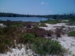
We paddled with a local group to Cayo Costa. This is an island State Park accessible only by boat. It is very narrow, very pristine, and there are very interesting channels and lagoons at the edges.
The navigation is a little tricky. I recommend you try to paddle with locals if you can. Park and unload at a little park off Pineland road. There are exactly 6 parking spaces. You likely will have to move your car to a parking lot across the street and to the north. This is the parking lot for Randell Research, a publicly funded interpretive and research site focusing on local archeological findings.
From Pineland, paddle roughly west and south to Murdock Bay. There are several islands in Pine Island sound, including Cabbage Key and Useppa Island. You could stop there for lunch or water if you wish. If you find Murdock Bay, which is a little tricky, there is a mangrove tunnel at the north end which will lead you, with many turns, to a lagoon and a very thin section of the island. From there, portage across or leave the boats and just walk. The beach is gorgeous. We had calm seas and enjoyed swimming and a little paddling before returning.
Lover's Key:
Not to be missed out of all your paddling choices in this area. This is a barrier island with several trails for different skill level. We chose to launch from the concession stand and paddle to a channel which leads to the Gulf. When we could see the Gulf, we realized the waves were too big for us so we turned south, followed the channel into Estero Bay, then explored a series of canals back to the boat ramp. The canals seem to be man made and a pod of manatees put on an extended show for us.
There are many other paddling choices in this area. For more information, check out their website: www.calusablueway.com/landing/explore
Accommodations:
Very nice campground
Fees:
Campsite fee is $22 per night.
State park entrance fee $5.
Directions:
Koreshan State Park (3800 Corkscrew Road, 33928): I-75 to exit #123. West 3 miles to the State park entrance.
Randell Research (13810 Waterfront Drive, Pineland, 33945)Tamiami trail to Colinial blvd, then west 12 miles to CR 78. Left on CR 78 then 5 miles to Stringfellow. Go 3 miles then left on Pineland. The ramp is on the left, parking lot on the right.
Lover's Key:From I-75: Exit 116, Bonita Beach Rd. Go East 10.5 mi. The park entrance is on the left, 1 mi. north of New Pass.
Resources:
maps available at www.GreatCalusaBlueway.com
Trip Details
- Trip Duration: 2-3 Day Trip
- Sport/Activity: Kayaking
- Skill Level: Intermediate
- Water Type: River/Creek (Up to Class II)