
Buffalo Bayou in Texas
Trip Overview

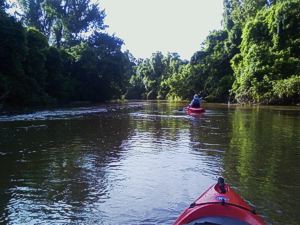
Buffalo Bayou is an overlooked playground. This shady intimate waterway, offers unexpected solitude, often within 50 yards of the upscale homes whose backyards, decks and wild borders share the banks. You nearly forget youre in the City with many - mile stretches of uninterrupted wild areas.
Hawks, several varieties of herons, and smaller fisher bird will give way and watch curiously as you float by don't rush by and miss the herons fishing show. Ive seen many tracks of raccoon and possum and weve seen 2 young raccoons watching us from the overhanging foliage. If you dont see the turtles on the logs and banks, youll hear them as they jump in and possibly see them as they surface to check you out.
Most of the route is navigable without portage or poling over shallows. As with all small waterways, care should be exercised with fallen logs and strainers. With a little back-paddling to study the snags, the obstructions are usually passable. A bit of quicker & riffled water can be found under some of the bridges and overpasses.
 The water can be accessed from numerous places along its East/West meander across Houston. Since I live close, Ive launched at Kirkwood, West Belt and Briar Bend Park.
These are on the up-stream section. Routes further up-stream are mentioned in other texts, but my scouting along the adjacent hiking path in Terry Hershey park has shown more snags and strainers, west of Kirkwood, than I was willing to run. This may change from time-to-time.
Terry Hershey Park offers paved paths to the accesses at Kirkwood and West Belt with generous parking area at West Belt, none at Kirkwood. Both are a 200 yard carry, so bring your Yak-dolly or share the load with a friend. Since I was dropped off, I havent tried parking in the neighborhood north of the Kirkwood put-in and will not comment on practicality.
Routes vary from 1-1/4 to 3-1/2 hours depending on flow and paddling enthusiasm
Buffalo Bayou does take in a great deal of water from storm drainage and is subject to the debris and cast-offs of negligent modern culture---cups, bags, cans--thrown on the roadsides. Its natural beauty is evident in spite of this condition.
The warnings of bacterial and chemical contamination, also, cannot be overlooked. Planning is best, in this and all waterways close to human settlements: Hand washing before eating, covering drinking containers and protecting from contamination. The waters have been recently tested and are reported "to be much cleaner that in the past," -- as enigmatic as that seems.
Fees:
No Permits or fees are necessary in any of these locations
Directions:
From farthest west:
Kirkwood -- Take Kirkwood south from I-10 about 1.6 miles to Heather Forest. Pull up on the side street, unload your gear, follow the sidewalk south, beside and below the west side of the overpass. The put-in is below the overpass just 20 ft. or so off the hike/ bike path. Keymap 489-J
West Belt Take Beltway 8 feeder south about 1.5 miles from I-10 past Memorial. The Parking lot will be on the right, under the overpass. The path will get you within 20 ft. of the water. Keymap 489-M
Briar Bend Take Voss south from I-10, past San Felipe to Creekwood. Right on Creekwood to Woodway and several blocks to the Park. On the North side of the park, take the switch-back trail down to the water. There is street-side parking. Keymap 490-R
Post Oak access 610 West Loop, Exit Woodwaygo West, away from Downtown, barely a block. The parking area will be on your left. Do not make an illegal left turn. Continue until you can turn left legally. The trail is beyond the West end of the parking area, past the Paddle-Trail Map. Keymap 491-M
Resources:
pdf file map on the web:
www.tpwd.state.tx.us/fishboat/boat/paddlingtrails/
Trip Details
- Sport/Activity: Kayaking
- Skill Level: Beginner
- Water Type: River/Creek (Up to Class II)