
Brazos River in Texas
Trip Overview
 I put in just below Whitney dam near Meridian, Texas, and paddled first to Waco and then to Bryan College Station. Due to the time of year the weather was hot/humid and there were lots of bugs. The stretch between Whitney and Waco was the nicest, with lots of wild life and scenery. A creek called Cedar Creek tumbles down about 50 feet of cascade to the river and makes a very welcome cool swimming hole after the hot river water.
Water releases from Whitney can result in rapid changes in flow with depth increasing as much as 4 feet. There are numerous places at low flow, where it will be necessary to walk your boat.
Wild life includes, Armadillos, Deer, occasional wild horses, foxes, raccoons, Ring-tailed cats, bobcats, and of course snakes, turtles, frogs, lizards and many other critters. I saw more deer than I saw snakes and turtles combined. The area is a bird watchers paradise, with many different large and small species.
As paddlers approach Waco, flow diminishes and ceases all together due to a large low water dam backing up what is called Lake Brazos. Be prepared to paddle against prevailing breezes for as much as 20 miles through the Wortham & Steinbeck bend area. Camping opportunities are also sparse in this stretch. The best take out in Waco is at the Baylor University Marina.
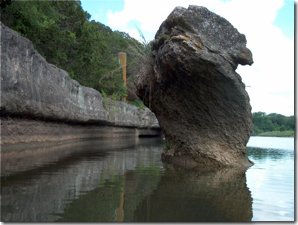
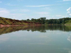 The river below Waco is a chain of relatively deep channels with one side a steep red clay/sand mixture and the other side a low jungle of vines and tall grasses and weeds. In some places the trees with vines of Mustang grapes hang down to the river level. Consider these to be entrapment hazards, as they can easily entangle your boat.
Between flat water pools are shallow rapids, or if sufficient flow is present some may provide nice class 1 currents.
Along the river are many historical monuments and old steamboat landings, although most are too grown up to be recognized.
Below Houston, the river becomes too brackish for drinking and paddlers must carry all their own water, and as the Freeport area is approached, the river is a hazard due to heavy shipping traffic which impacts the river in several ways.
Take a machete to assist in exiting the river, and take a lot of sun block, and deep woods off. Ward off chiggers and be very careful of poison ivy that is everywhere. Remember that you will be camping on private land, so ask permission wherever possible. Tie you boat to a tree limb over your head to avoid nasty surprises after flows come up over night. Take earplugs if the cicadas bother you, they can be very loud. Below Waco arrange to paddle upstream and return to your car, or have someone meet you at crossings and bridges with water and food. Don't do this trip by yourself, I did and wish I had had a companion.
Accommodations:
Laguna Park at Whitney has grocery stores and some limited accommodations. Check with the Whitney, Hillboro and Meridian Chambers of Commerce for facilities. Waco has medical services and a full selection of motels and restaurants. In fact, one may take our near the I-35 bridge and be within walking distance of museums and motels and restaurants.
Directions:
From Dallas take I-35 south to Hillsboro, Take State Highway 22 to Whitney Dam, making the last left prior to crossing the dam proper. Follow road to the rocky area below the dam and carry boats to the water.
Resources:
I used USGS maps and I also monitored stream flows on the river using the USGS facilities. I recommend reading John Graves' book "Goodbye to a River".
Trip Details
- Trip Duration: 2-3 Day Trip
- Sport/Activity: Kayaking, Canoeing
- Skill Level: Advanced
- Water Type: River/Creek (Up to Class II)