
Banks Lake in Washington
Trip Overview
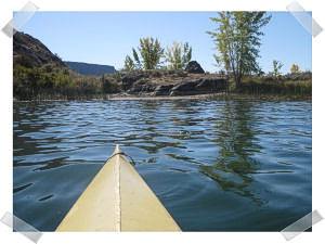
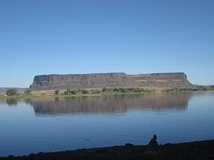
Banks Lake is a 35 mile long lake located in north central Washington well known for excellent fishing and with public campgrounds on the water. The lake itself forms part of the extensive Columbia Basin Irrigation project. Eagle Pass is a protected area just north of Steamboat Rock State Park that consists of rocky outcroppings of granite as big as islets or just rocks. I love to take a day and just play around these rocks and islets. This area is easily seen on Google Earth or other similar sites.
The major campground for the area is Steamboat Rock State Park which is a reservation-only state park (do a search for latest fees and instructions). The park has spacious camp sites with full hookups, lawns, bathrooms/showers, swimming areas and lots of sand beaches. Launching is convenient at the north end of the camping area adjacent to the boat ramp on sand beaches. There is a charge to launch and park (unless you have a disabled permit).
From the park launch ramp I like to paddle north into the maze of islets. The area is not large but it's still pretty easy to get mixed up in directions although you can't really get too far off.
The water in summer is warm enough for swimming and you can easily carry camping gear and find places to pitch a tent on the islands. Stores and restaurants are convenient in Grand Coulee about 14 miles north and there is a free laser show on Grand Coulee Dam in the summer every night.
 This area of Washington State is dry and arid and days are typically warm and sunny while nights cool down. Watch out for thunderstorms. There can be mosquitoes but no biting flies. Outside of the park you could find rattlesnakes. Although I've never seen one my daughter's two huskies found one at a rough campsite on the north end of Steamboat Island.
The waters of the Eagle Pass area are well protected but there can still be significant afternoon winds generally from the west or northwest. West of Steamboat Rock the water is more exposed to the north and south and waves up to 2' could occur. Also, due to the popularity of the lake for fishing there can be a lot of power boat traffic; especially on summer weekends. This traffic can be significant on major holiday weekends.
Accommodations:
The state park requires advance reservations (www.parks.wa.gov for current information). Sites are almost all full hookups.
Coulee City has a nice municipal park on the water next to US highway 2. There are several privately operated parks near Grand Coulee. Restaurants, stores, fuel and pharmacies are located in Grand Coulee plus a casino operated by a local native American tribe.
Fees:
Launch fees may be required; check posted signs. Campsites are typically fee-based.
Directions:
From Seattle, take I-90 east to George and then turn north to Ephrata, Soap Lake and Coulee City on State Routes 283 and then 17. Then take US2 east to the intersection with State Route 155 towards Grand Coulee and drive about 20 miles north to the well-marked road to Steamboat Rock (the Rock is easily spotted from miles away).
Resources:
Google maps, yahoo maps or map quest can provide you with more than enough information to make a safe trip.
Trip Details
- Trip Duration: Day Trip, 2-3 Day Trip
- Sport/Activity: Kayaking, Canoeing
- Skill Level: Beginner
- Water Type: Flat/Sheltered Water