
Allegheny River in Pennsylvania
Trip Overview
 From its headwaters in western New York State, the Allegheny River meanders southward through the wooded hills of western Pennsylvania. Starting at the Allegheny Reservoir formed by Kinzua Dam near Warren, PA, the river flows over 200 miles to its confluence with the Monongehela River at Pittsburg, but there are nine locks or dams below Emlenton. Several canoe and kayak outfitters are along the Allegheny and some of its tributaries like the Clarion River and French Creek.
We decided to paddle the 42-mile segment from the town of Franklin to Emlenton. With the help of our son Paul, we shuttled a vehicle to our take-out spot. As he drove away we knew we were committed to completing the 42 miles in two or three days. Phyllis had loaded our gear in the kayaks while Paul and I were gone, so we quickly took to the water. It was after 11 a.m. but the fog of the night before was still dissipating. The date was September 27, so there were touches of fall color in the trees along the banks. For days the weather predictions had called for rain, but the days were beautiful. The first frosts would come soon, but we were experienced with kayak touring when the nights dipped below freezing.
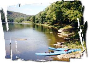
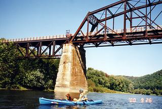
We stopped for lunch on a warm rock. It was hard to judge our progress because there are few unique landmarks. There is an old railroad bridge near East Sandy, now converted as part of the rail-trail, which follows this river segment. There were summer cabins along the banks much of the time, some quite nice, some under construction. Steep, wooded hills rose from the river on both sides. The river was usually 80 to 100 yards wide, with few rock obstructions and only occasional riffles. At times we could see the rocky bottom, but never ran aground. We saw lots of birds: great blue herons, geese, mallards, mergansers, kingfishers, ospreys, hawks, and one bald eagle.
 Our destination for the first day was the state forest tract near the village of Kennerdell. When we arrived at the Danner Rest Stop, we were pleased to find lots of nice campsites, with picnic tables, fire rings, and a composting outhouse. No one else was camping there. We set up camp and enjoyed the late afternoon sun on the river. It was very quiet in the camp. Occasionally we would hear acorns falling through the leaves of the red oak trees and thudding on the ground.
After dinner I tried to start a campfire in the fire ring, but all the wood was damp from recent rains. It burned feebly for ten minutes, and then went out. We decided to go to bed. Freezing temps were predicted during the night.
Morning dawned with overcast skies that kept the night temperatures well above freezing. There was no fog and very little dew on the tent rainfly. We had a leisurely breakfast and packed our kayaks, heading on at 10 am.
The river flowed mostly south, but meanders took us west, east, and due north. There were a few riffles to give us some added speed, but we averaged about five mph. We stopped for lunch on another big rock, and reached our take-out at Emlenton by mid-afternoon. It was one of our most enjoyable river trips.
Accommodations:
Good camping at Kennerdell
Directions:
Park shuttle vehicle at Emlenton. Put-in at park near bridge in Franklin.
Resources:
Delorme topo maps of Pennsylvania
Trip Details
- Trip Duration: Day Trip
- Sport/Activity: Kayaking
- Skill Level: Beginner
- Water Type: River/Creek (Up to Class II)